Property Record
917 3Rd St, Camanche, IA 52730

Save to a Folder
{{folder.Name}}
{{folder.ListingIds.length}} Properties
{{folder.ListingIds.length}} Property
Create a New Folder
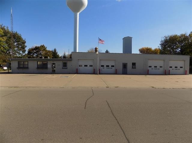
Property Detail
917 3Rd St
Clinton, IA
BLOCKS WEST OF FERRY ST IN RANGES 1 & 2 LOTS 5 & 6 BLK 10 RG 2& EASTERLY 10 FT OF 10TH AVE R-O-W BETWEEN 3RD ST &
10-0170-0000
Clinton
Commercialnec
Iowa
B and X Area of moderate flood hazard, usually the area between the limits of the 100-year and 500-year floods.
5,6
2025
0.43 AC
2025
Iowa Southeast Area
000800
Other Market Areas
5,189 SF
NEARBY LISTINGS FOR SALE OR LEASE
-
-
View all Camanche listings for sale on LoopNet.com
DEMOGRAPHICS near 917 3Rd St
1 mile
3 mile
5 mile
2025 Total Population
3,620
6,420
16,230
2030 Population
3,602
6,404
16,160
Pop Growth 2025-2030
(0.50%)
(0.25%)
(0.43%)
Average Age
43
43
42
2025 Total Households
1,544
2,731
6,753
HH Growth 2025-2030
(0.58%)
(0.29%)
(0.50%)
Median Household Inc
$66,658
$69,037
$66,365
Avg Household Size
2.30
2.30
2.30
2025 Avg HH Vehicles
2.00
2.00
2.00
Median Home Value
$176,478
$175,399
$147,744
Median Year Built
1972
1973
1962
Nearby Places
Map Layers
Map Styles
 Street
 Aerial
Layers
 Traffic
 Biking
Places
Listings with unknown addresses are not visible on the map
- Restaurants
- Banks
- Shops
- Fitness
- Groceries
PUBLIC TRANSPORTATION
AIRPORT
Quad Cities International
Drive
Walk
Distance
Quad Cities International
59 min
40.9 mi
Freight Ports
Port Milwaukee
Drive
Walk
Distance
Port Milwaukee
228 min
189.1 mi
SALE & LEASE HISTORY
LISTING DATE
SALE/LEASE

May 15, 2018
For Sale
Nearby Properties
Address
Land Use
TOTAL SIZE
Lot Size
Zoning
Address
Land Use
TOTAL SIZE
Lot Size
Zoning
57.49 AC
Address
Land Use
TOTAL SIZE
Lot Size
Zoning
6,900 SF
22.90 AC
Address
Land Use
TOTAL SIZE
Lot Size
Zoning
288 SF
73.70 AC
Address
Land Use
TOTAL SIZE
Lot Size
Zoning
27,943 SF
22.53 AC
Address
Land Use
TOTAL SIZE
Lot Size
Zoning
200,102 SF
20.14 AC
Address
Land Use
TOTAL SIZE
Lot Size
Zoning
86 AC
I2
Address
Land Use
TOTAL SIZE
Lot Size
Zoning
7,344 SF
75.50 AC
Address
Land Use
TOTAL SIZE
Lot Size
Zoning
9,028 SF
9.36 AC
Address
Land Use
TOTAL SIZE
Lot Size
Zoning
392,800 SF
31.40 AC
Address
Land Use
TOTAL SIZE
Lot Size
Zoning
105,050 SF
10.43 AC
Address
Land Use
TOTAL SIZE
Lot Size
Zoning
480 SF
29.74 AC
Address
Land Use
TOTAL SIZE
Lot Size
Zoning
8,568 SF
83.75 AC
Address
Land Use
TOTAL SIZE
Lot Size
Zoning
92,418 SF
5.65 AC
Address
Land Use
TOTAL SIZE
Lot Size
Zoning
62,262 SF
11.09 AC
Address
Land Use
TOTAL SIZE
Lot Size
Zoning
10,085 SF
6.82 AC
Address
Land Use
TOTAL SIZE
Lot Size
Zoning
45,275 SF
1.92 AC
Address
Land Use
TOTAL SIZE
Lot Size
Zoning
91,012 SF
8.10 AC
Address
Land Use
TOTAL SIZE
Lot Size
Zoning
2,100 SF
35.85 AC
Address
Land Use
TOTAL SIZE
Lot Size
Zoning
50,436 SF
3.11 AC
Address
Land Use
TOTAL SIZE
Lot Size
Zoning
3,000 SF
Address
Land Use
TOTAL SIZE
Lot Size
Zoning
50,276 SF
1.19 AC
Address
Land Use
TOTAL SIZE
Lot Size
Zoning
1,200 SF
13.09 AC
Address
Land Use
TOTAL SIZE
Lot Size
Zoning
Address
Land Use
TOTAL SIZE
Lot Size
Zoning
40,846 SF
5.27 AC
Address
Land Use
TOTAL SIZE
Lot Size
Zoning
25,684 SF
12.50 AC
Address
Land Use
TOTAL SIZE
Lot Size
Zoning
36.17 AC
I2
Address
Land Use
TOTAL SIZE
Lot Size
Zoning
5,880 SF
5.51 AC
Address
Land Use
TOTAL SIZE
Lot Size
Zoning
5,190 SF
4.90 AC
The World's #1 Commercial Real Estate Marketplace
Connect with us
© 2026 CoStar Group
The information above has been obtained from sources believed reliable. While we do not doubt its accuracy we have not verified it and make no guarantee, warranty or representation about it. It is your responsibility to independently confirm its accuracy and completeness. Any projections, opinions, assumptions, or estimates used are for example only and do not represent the current or future performance of the property. The value of this transaction to you depends on tax and other factors which should be evaluated by your tax, financial, and legal advisors. You and your advisors should conduct a careful, independent investigation of the property to determine to your satisfaction the suitability of the property for your needs.