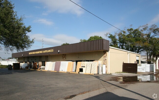
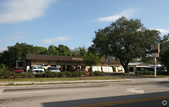
Property Record
917 9Th St W, Bradenton, FL 34205
NEARBY LISTINGS FOR SALE OR LEASE
Property Detail
917 9Th St W
North Port-Bradenton-Sarasota, FL
Drymans Resubdivided
43171-0000-8
LOT 6 RESUB DRYMAN 3RD SUB PI#43171.0000/8
Storemultistory
Manatee
X
Florida
12081C0302F
6
2024
0.21 AC
2025
Manatee
000103
Tampa/St Petersburg
8,174 SF
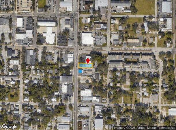
DEMOGRAPHICS near 917 9Th St W
1 mile
3 mile
5 mile
2024 Total Population
13,841
101,846
215,352
2029 Population
16,303
119,086
251,610
Pop Growth 2024-2029
+ 17.79%
+ 16.93%
+ 16.84%
Average Age
43
43
44
2024 Total Households
5,897
41,189
89,414
HH Growth 2024-2029
+ 17.65%
+ 16.30%
+ 16.14%
Median Household Inc
$47,351
$46,639
$50,870
Avg Household Size
2.10
2.30
2.30
2024 Avg HH Vehicles
1.00
2.00
2.00
Median Home Value
$217,316
$179,679
$221,226
Median Year Built
1971
1975
1980
Nearby Places
Map Layers
Map Styles
 Street
 Aerial
Transit
 Traffic
 Biking
Places
Listings with unknown addresses are not visible on the map
- Restaurants
- Banks
- Shops
- Fitness
- Groceries
PUBLIC TRANSPORTATION
AIRPORT
Sarasota/Bradenton International
Drive
Walk
Distance
Sarasota/Bradenton International
16 min
7.6 mi
St Pete-Clearwater International
Drive
Walk
Distance
St Pete-Clearwater International
48 min
35.9 mi
Tampa International
Drive
Walk
Distance
Tampa International
59 min
45.1 mi
Freight Ports
Port Manatee
Drive
Walk
Distance
Port Manatee
21 min
12.0 mi
Nearby Properties
Address
Land Use
TOTAL SIZE
Lot Size
Zoning
Address
Land Use
TOTAL SIZE
Lot Size
Zoning
595,475 SF
16.90 AC
BR_T5
Address
Land Use
TOTAL SIZE
Lot Size
Zoning
349,711 SF
49.51 AC
BR_SD1
Address
Land Use
TOTAL SIZE
Lot Size
Zoning
405,843 SF
9.09 AC
BR_T5
Address
Land Use
TOTAL SIZE
Lot Size
Zoning
277,678 SF
7.80 AC
BR_T4-O, B
Address
Land Use
TOTAL SIZE
Lot Size
Zoning
427,250 SF
38.18 AC
A-1 SUBURB
Address
Land Use
TOTAL SIZE
Lot Size
Zoning
98,722 SF
10.24 AC
PL_P
Address
Land Use
TOTAL SIZE
Lot Size
Zoning
432,078 SF
1.64 AC
BR_T6
Address
Land Use
TOTAL SIZE
Lot Size
Zoning
169,485 SF
7.87 AC
PD-MU
Address
Land Use
TOTAL SIZE
Lot Size
Zoning
318,507 SF
10.47 AC
BR_T4R,BR_
Address
Land Use
TOTAL SIZE
Lot Size
Zoning
2,401,721 SF
142.14 AC
PD-UI
Address
Land Use
TOTAL SIZE
Lot Size
Zoning
247,280 SF
17.72 AC
PD-R
Address
Land Use
TOTAL SIZE
Lot Size
Zoning
257,072 SF
10.07 AC
BR_T5
Address
Land Use
TOTAL SIZE
Lot Size
Zoning
214,906 SF
20.71 AC
BR_R-1
Address
Land Use
TOTAL SIZE
Lot Size
Zoning
397,863 SF
21.60 AC
GC GENERA
Address
Land Use
TOTAL SIZE
Lot Size
Zoning
541,781 SF
3.48 AC
BR_T5
Address
Land Use
TOTAL SIZE
Lot Size
Zoning
885,776 SF
46.22 AC
LM LIGHT M
Address
Land Use
TOTAL SIZE
Lot Size
Zoning
318,680 SF
1.31 AC
BR_FBC,BR_
Address
Land Use
TOTAL SIZE
Lot Size
Zoning
499,823 SF
39.50 AC
PL_P
Address
Land Use
TOTAL SIZE
Lot Size
Zoning
247,592 SF
13.39 AC
GC,RMF-6
Address
Land Use
TOTAL SIZE
Lot Size
Zoning
7,785 SF
75.25 AC
Address
Land Use
TOTAL SIZE
Lot Size
Zoning
198,036 SF
8.32 AC
GC GENERA
Address
Land Use
TOTAL SIZE
Lot Size
Zoning
185,617 SF
13.68 AC
BR_R-2
Address
Land Use
TOTAL SIZE
Lot Size
Zoning
166,810 SF
3.16 AC
BR_T4-O
Address
Land Use
TOTAL SIZE
Lot Size
Zoning
276,469 SF
10.90 AC
PD-MU
Address
Land Use
TOTAL SIZE
Lot Size
Zoning
163,582 SF
8.61 AC
PL_P
Address
Land Use
TOTAL SIZE
Lot Size
Zoning
196,346 SF
33.03 AC
BR_R-1
Address
Land Use
TOTAL SIZE
Lot Size
Zoning
148,992 SF
9.81 AC
RMF-9,GC
Address
Land Use
TOTAL SIZE
Lot Size
Zoning
183,257 SF
4.19 AC
PD-R
Address
Land Use
TOTAL SIZE
Lot Size
Zoning
6,525 SF
43.70 AC
RSMH-6
Address
Land Use
TOTAL SIZE
Lot Size
Zoning
193,682 SF
10.67 AC
PD-C
The World's #1 Commercial Real Estate Marketplace
Connect with us
© 2026 CoStar Group
The information above has been obtained from sources believed reliable. While we do not doubt its accuracy we have not verified it and make no guarantee, warranty or representation about it. It is your responsibility to independently confirm its accuracy and completeness. Any projections, opinions, assumptions, or estimates used are for example only and do not represent the current or future performance of the property. The value of this transaction to you depends on tax and other factors which should be evaluated by your tax, financial, and legal advisors. You and your advisors should conduct a careful, independent investigation of the property to determine to your satisfaction the suitability of the property for your needs.