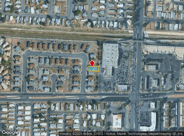
Property Record
917 Snug Harbor St, Las Vegas, NV 89110
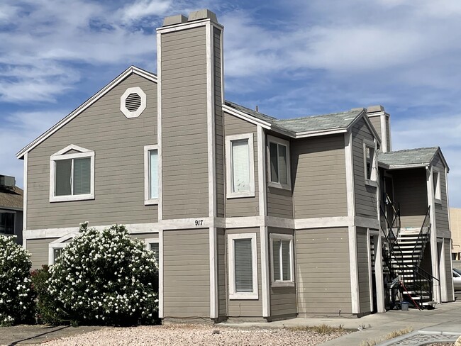


This Property Is For Sale
NEARBY LISTINGS FOR SALE OR LEASE
Property Detail
917 Snug Harbor St
Las Vegas-Henderson-Paradise, NV
Village At Washington
140-30-610-024
VILLAGE AT WASHINGTON PLAT BOOK 28 PAGE 9 LOT 24 BLOCK 1
Quadruplex
Clark
X
Nevada
32003C2187F
24
2025
0.13 AC
2025
East Las Vegas
000527
Las Vegas
2,896 SF
DEMOGRAPHICS near 917 Snug Harbor St
1 Mile
3 Mile
5 Mile
2024 Total Population
35,487
232,774
457,220
2029 Population
38,012
248,701
488,968
Pop Growth 2024-2029
+ 7.12%
+ 6.84%
+ 6.94%
Average Age
34
35
36
2024 Total Households
10,851
73,341
153,559
HH Growth 2024-2029
+ 7.04%
+ 6.88%
+ 7.02%
Median Household Inc
$35,222
$38,803
$41,342
Avg Household Size
3.10
3.00
2.80
2024 Avg HH Vehicles
2.00
2.00
2.00
Median Home Value
$205,033
$228,308
$249,741
Median Year Built
1989
1983
1984
Nearby Places
- Restaurants
- Banks
- Shops
- Fitness
- Groceries
PUBLIC TRANSPORTATION
AIRPORT
Harry Reid International
DRIVE
WALK
Distance
Harry Reid International
20 min
11.6 mi
Boulder City Municipal
DRIVE
WALK
Distance
Boulder City Municipal
34 min
25.0 mi
Nearby Properties
Address
Land Use
TOTAL SIZE
Lot Size
Zoning
Address
Land Use
TOTAL SIZE
Lot Size
Zoning
324 SF
8.74 AC
R1
Address
Land Use
TOTAL SIZE
Lot Size
Zoning
1,608 SF
30.32 AC
RAPSP
Address
Land Use
TOTAL SIZE
Lot Size
Zoning
6,396 SF
15.06 AC
Address
Land Use
TOTAL SIZE
Lot Size
Zoning
191,879 SF
12 AC
RACHE
Address
Land Use
TOTAL SIZE
Lot Size
Zoning
546,249 SF
28.58 AC
Address
Land Use
TOTAL SIZE
Lot Size
Zoning
67,649 SF
13.42 AC
CV
Address
Land Use
TOTAL SIZE
Lot Size
Zoning
22.77 AC
CV
Address
Land Use
TOTAL SIZE
Lot Size
Zoning
29.35 AC
CV
Address
Land Use
TOTAL SIZE
Lot Size
Zoning
342,160 SF
37.72 AC
RT
Address
Land Use
TOTAL SIZE
Lot Size
Zoning
15.95 AC
PF
Address
Land Use
TOTAL SIZE
Lot Size
Zoning
201,218 SF
36.38 AC
Address
Land Use
TOTAL SIZE
Lot Size
Zoning
20.91 AC
PF
Address
Land Use
TOTAL SIZE
Lot Size
Zoning
1,008 SF
31.47 AC
PF
Address
Land Use
TOTAL SIZE
Lot Size
Zoning
58,188 SF
20.04 AC
L:C-V
Address
Land Use
TOTAL SIZE
Lot Size
Zoning
339,280 SF
18.19 AC
Address
Land Use
TOTAL SIZE
Lot Size
Zoning
4.34 AC
RE
Address
Land Use
TOTAL SIZE
Lot Size
Zoning
7,068 SF
47.05 AC
CV
Address
Land Use
TOTAL SIZE
Lot Size
Zoning
374,712 SF
18.88 AC
MD
Address
Land Use
TOTAL SIZE
Lot Size
Zoning
582,492 SF
38.08 AC
Address
Land Use
TOTAL SIZE
Lot Size
Zoning
19.30 AC
RE
Address
Land Use
TOTAL SIZE
Lot Size
Zoning
420,000 SF
21.23 AC
M1
Address
Land Use
TOTAL SIZE
Lot Size
Zoning
237,348 SF
12.92 AC
Address
Land Use
TOTAL SIZE
Lot Size
Zoning
421,000 SF
19.59 AC
M1
Address
Land Use
TOTAL SIZE
Lot Size
Zoning
223,422 SF
18.21 AC
R3
Address
Land Use
TOTAL SIZE
Lot Size
Zoning
9,044 SF
8.62 AC
Address
Land Use
TOTAL SIZE
Lot Size
Zoning
2,926 SF
19.73 AC
R3
Address
Land Use
TOTAL SIZE
Lot Size
Zoning
3,183 SF
18.35 AC
R3
Address
Land Use
TOTAL SIZE
Lot Size
Zoning
307,997 SF
14.01 AC
Address
Land Use
TOTAL SIZE
Lot Size
Zoning
7,268 SF
35.78 AC
PSP
Address
Land Use
TOTAL SIZE
Lot Size
Zoning
9.11 AC
PF
The World's #1 Commercial Real Estate Marketplace
Connect with us
© 2025 CoStar Group
The information above has been obtained from sources believed reliable. While we do not doubt its accuracy we have not verified it and make no guarantee, warranty or representation about it. It is your responsibility to independently confirm its accuracy and completeness. Any projections, opinions, assumptions, or estimates used are for example only and do not represent the current or future performance of the property. The value of this transaction to you depends on tax and other factors which should be evaluated by your tax, financial, and legal advisors. You and your advisors should conduct a careful, independent investigation of the property to determine to your satisfaction the suitability of the property for your needs.