Property Record
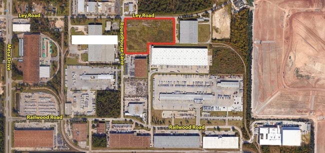
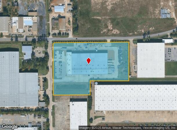
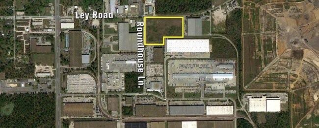
9172 Ley Rd, Houston, TX 77078

NEARBY LISTINGS FOR SALE OR LEASE
Property Detail
9172 Ley Rd
1301670010001
Railwood Sec 10
Outdoorrecreationbeachmountaindesert
RES A BLK 1 RAILWOOD SEC 10
X
Harris
48201C0685L
Texas
0
10.83 AC
2025
Northeast Near
231100
Houston
116,356 SF
Houston-Pasadena-The Woodlands, TX
DEMOGRAPHICS near 9172 Ley Rd
1 mile
3 mile
5 mile
2024 Total Population
4,487
49,254
195,869
2029 Population
4,599
50,949
201,355
Pop Growth 2024-2029
+ 2.50%
+ 3.44%
+ 2.80%
Average Age
34
36
36
2024 Total Households
1,296
15,235
62,743
HH Growth 2024-2029
+ 2.55%
+ 3.40%
+ 2.77%
Median Household Inc
$24,473
$34,809
$40,910
Avg Household Size
3.30
3.10
3.00
2024 Avg HH Vehicles
2.00
2.00
2.00
Median Home Value
$92,722
$94,118
$122,878
Median Year Built
1961
1978
1975
Nearby Places
Map Layers
Map Styles
 Street
 Aerial
Transit
 Traffic
 Biking
Places
Listings with unknown addresses are not visible on the map
- Restaurants
- Banks
- Shops
- Fitness
- Groceries
PUBLIC TRANSPORTATION
AIRPORT
William P Hobby
Drive
Walk
Distance
William P Hobby
31 min
17.2 mi
George Bush Intcntl/Houston
Drive
Walk
Distance
George Bush Intcntl/Houston
30 min
18.1 mi
SALE & LEASE HISTORY
LISTING DATE
SALE/LEASE

Sep 24, 2016
For Sale
Mar 21, 2017
For Sale
Nearby Properties
Address
Land Use
TOTAL SIZE
Lot Size
Zoning
Address
Land Use
TOTAL SIZE
Lot Size
Zoning
602,940 SF
30.90 AC
Address
Land Use
TOTAL SIZE
Lot Size
Zoning
663,147 SF
40.63 AC
Address
Land Use
TOTAL SIZE
Lot Size
Zoning
228,576 SF
11.46 AC
Address
Land Use
TOTAL SIZE
Lot Size
Zoning
422,526 SF
27.45 AC
Address
Land Use
TOTAL SIZE
Lot Size
Zoning
351,250 SF
23.84 AC
Address
Land Use
TOTAL SIZE
Lot Size
Zoning
357,510 SF
29.15 AC
Address
Land Use
TOTAL SIZE
Lot Size
Zoning
438,196 SF
89.88 AC
Address
Land Use
TOTAL SIZE
Lot Size
Zoning
214,200 SF
12.92 AC
Address
Land Use
TOTAL SIZE
Lot Size
Zoning
215,705 SF
39.58 AC
Address
Land Use
TOTAL SIZE
Lot Size
Zoning
311,550 SF
12.49 AC
Address
Land Use
TOTAL SIZE
Lot Size
Zoning
150,632 SF
36.03 AC
Address
Land Use
TOTAL SIZE
Lot Size
Zoning
198,306 SF
8.41 AC
Address
Land Use
TOTAL SIZE
Lot Size
Zoning
300,000 SF
12.83 AC
Address
Land Use
TOTAL SIZE
Lot Size
Zoning
264,866 SF
10.46 AC
Address
Land Use
TOTAL SIZE
Lot Size
Zoning
261,327 SF
19.31 AC
Address
Land Use
TOTAL SIZE
Lot Size
Zoning
296,850 SF
20.04 AC
Address
Land Use
TOTAL SIZE
Lot Size
Zoning
411,028 SF
34.67 AC
Address
Land Use
TOTAL SIZE
Lot Size
Zoning
210,220 SF
15.38 AC
Address
Land Use
TOTAL SIZE
Lot Size
Zoning
254,904 SF
9.27 AC
Address
Land Use
TOTAL SIZE
Lot Size
Zoning
346,320 SF
12.55 AC
Address
Land Use
TOTAL SIZE
Lot Size
Zoning
199,340 SF
13.27 AC
Address
Land Use
TOTAL SIZE
Lot Size
Zoning
229,050 SF
8.13 AC
Address
Land Use
TOTAL SIZE
Lot Size
Zoning
138,600 SF
12.29 AC
Address
Land Use
TOTAL SIZE
Lot Size
Zoning
264,022 SF
12.81 AC
Address
Land Use
TOTAL SIZE
Lot Size
Zoning
75,598 SF
27.98 AC
Address
Land Use
TOTAL SIZE
Lot Size
Zoning
254,496 SF
18.22 AC
Address
Land Use
TOTAL SIZE
Lot Size
Zoning
191,567 SF
7.06 AC
Address
Land Use
TOTAL SIZE
Lot Size
Zoning
132,800 SF
8 AC
Address
Land Use
TOTAL SIZE
Lot Size
Zoning
201,128 SF
8.11 AC
Address
Land Use
TOTAL SIZE
Lot Size
Zoning
108,783 SF
8.83 AC
The World's #1 Commercial Real Estate Marketplace
Connect with us
© 2026 CoStar Group
The information above has been obtained from sources believed reliable. While we do not doubt its accuracy we have not verified it and make no guarantee, warranty or representation about it. It is your responsibility to independently confirm its accuracy and completeness. Any projections, opinions, assumptions, or estimates used are for example only and do not represent the current or future performance of the property. The value of this transaction to you depends on tax and other factors which should be evaluated by your tax, financial, and legal advisors. You and your advisors should conduct a careful, independent investigation of the property to determine to your satisfaction the suitability of the property for your needs.