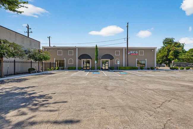
Property Record
918 Oak Glen Dr, Houston, TX 77076
Current Lease Availabilities
NEARBY LISTINGS FOR SALE OR LEASE
Property Detail
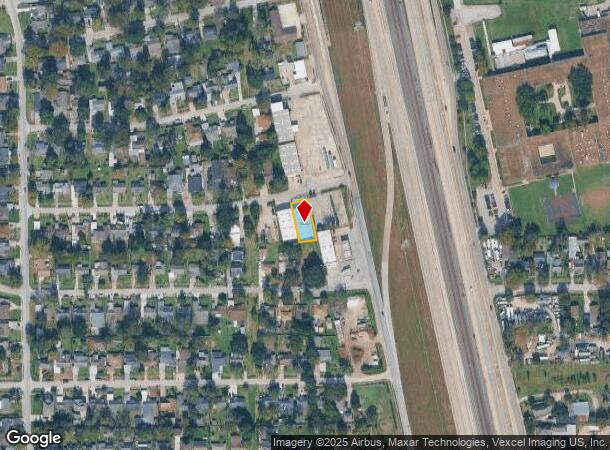
918 Oak Glen Dr
Houston-The Woodlands-Sugar Land, TX
Hawthorne Place Sec 9
0750700620116
LT 1116 BLK 59 HAWTHORNE PLACE SEC 9
Warehouse
Harris
X
Texas
48201C0680L
1116
0
0.19 AC
2025
North Outer Loop
221200
Houston
5,000 SF
DEMOGRAPHICS near 918 Oak Glen Dr
1 Mile
3 Mile
5 Mile
2024 Total Population
14,471
124,873
324,528
2029 Population
15,350
132,360
346,825
Pop Growth 2024-2029
+ 6.07%
+ 6.00%
+ 6.87%
Average Age
36
35
37
2024 Total Households
3,936
36,744
104,994
HH Growth 2024-2029
+ 6.22%
+ 6.16%
+ 7.21%
Median Household Inc
$52,937
$44,344
$51,540
Avg Household Size
3.50
3.30
3.00
2024 Avg HH Vehicles
2.00
2.00
2.00
Median Home Value
$178,064
$173,863
$206,076
Median Year Built
1957
1966
1968
Nearby Places
- Restaurants
- Banks
- Shops
- Fitness
- Groceries
PUBLIC TRANSPORTATION
COMMUTER RAIL
Houston (Sunset Limited - Amtrak)
DRIVE
WALK
Distance
Houston (Sunset Limited - Amtrak)
14 min
8.8 mi
AIRPORT
George Bush Intcntl/Houston
DRIVE
WALK
Distance
George Bush Intcntl/Houston
16 min
11.9 mi
William P Hobby
DRIVE
WALK
Distance
William P Hobby
34 min
20.6 mi
Freight Ports
Port of Houston
DRIVE
WALK
Distance
Port of Houston
22 min
14.5 mi
Nearby Properties
Address
Land Use
TOTAL SIZE
Lot Size
Zoning
Address
Land Use
TOTAL SIZE
Lot Size
Zoning
474,326 SF
43.16 AC
Address
Land Use
TOTAL SIZE
Lot Size
Zoning
594,105 SF
43.68 AC
Address
Land Use
TOTAL SIZE
Lot Size
Zoning
545,628 SF
19.41 AC
Address
Land Use
TOTAL SIZE
Lot Size
Zoning
531,786 SF
17.60 AC
Address
Land Use
TOTAL SIZE
Lot Size
Zoning
194,990 SF
16.36 AC
Address
Land Use
TOTAL SIZE
Lot Size
Zoning
200,511 SF
9.48 AC
Address
Land Use
TOTAL SIZE
Lot Size
Zoning
188,582 SF
17.94 AC
Address
Land Use
TOTAL SIZE
Lot Size
Zoning
43.68 AC
Address
Land Use
TOTAL SIZE
Lot Size
Zoning
179,804 SF
11.24 AC
Address
Land Use
TOTAL SIZE
Lot Size
Zoning
85,376 SF
4.35 AC
Address
Land Use
TOTAL SIZE
Lot Size
Zoning
66,588 SF
3.95 AC
Address
Land Use
TOTAL SIZE
Lot Size
Zoning
29,029 SF
17.85 AC
Address
Land Use
TOTAL SIZE
Lot Size
Zoning
91,623 SF
9.09 AC
Address
Land Use
TOTAL SIZE
Lot Size
Zoning
261,236 SF
11.57 AC
Address
Land Use
TOTAL SIZE
Lot Size
Zoning
184,536 SF
10 AC
Address
Land Use
TOTAL SIZE
Lot Size
Zoning
108,155 SF
14.64 AC
Address
Land Use
TOTAL SIZE
Lot Size
Zoning
126,662 SF
4.77 AC
Address
Land Use
TOTAL SIZE
Lot Size
Zoning
112,212 SF
10.51 AC
Address
Land Use
TOTAL SIZE
Lot Size
Zoning
84,582 SF
4.86 AC
Address
Land Use
TOTAL SIZE
Lot Size
Zoning
69,777 SF
2.36 AC
Address
Land Use
TOTAL SIZE
Lot Size
Zoning
130,309 SF
13.28 AC
Address
Land Use
TOTAL SIZE
Lot Size
Zoning
48,420 SF
22.93 AC
Address
Land Use
TOTAL SIZE
Lot Size
Zoning
91,726 SF
6.23 AC
Address
Land Use
TOTAL SIZE
Lot Size
Zoning
139,709 SF
4.76 AC
Address
Land Use
TOTAL SIZE
Lot Size
Zoning
82,951 SF
21.32 AC
Address
Land Use
TOTAL SIZE
Lot Size
Zoning
86,400 SF
3.51 AC
Address
Land Use
TOTAL SIZE
Lot Size
Zoning
242,147 SF
12.51 AC
Address
Land Use
TOTAL SIZE
Lot Size
Zoning
51,941 SF
3.71 AC
Address
Land Use
TOTAL SIZE
Lot Size
Zoning
102,214 SF
11.26 AC
Address
Land Use
TOTAL SIZE
Lot Size
Zoning
48,420 SF
18.03 AC
The World's #1 Commercial Real Estate Marketplace
Connect with us
© 2025 CoStar Group
The information above has been obtained from sources believed reliable. While we do not doubt its accuracy we have not verified it and make no guarantee, warranty or representation about it. It is your responsibility to independently confirm its accuracy and completeness. Any projections, opinions, assumptions, or estimates used are for example only and do not represent the current or future performance of the property. The value of this transaction to you depends on tax and other factors which should be evaluated by your tax, financial, and legal advisors. You and your advisors should conduct a careful, independent investigation of the property to determine to your satisfaction the suitability of the property for your needs.