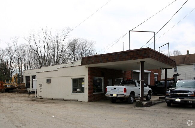
Property Record
918 Ringwood Ave, Haskell, NJ 07420


Property Detail
918 Ringwood Ave
New York-Jersey City-White Plains, NY-NJ
Passaic
13-00309-0000-00022
New Jersey
Servicestation
22
B and X Area of moderate flood hazard, usually the area between the limits of the 100-year and 500-year floods.
0.62 AC
2024
Upper Suburban Passaic
2025
Northern New Jersey
236601
NEARBY LISTINGS FOR SALE OR LEASE
-
-
-
-
No Photo
-
-
-
-
View all Haskell listings for lease on LoopNet.com
DEMOGRAPHICS near 918 Ringwood Ave
1 mile
3 mile
5 mile
2025 Total Population
6,661
36,463
101,201
2030 Population
6,889
37,802
104,757
Pop Growth 2025-2030
+ 3.42%
+ 3.67%
+ 3.51%
Average Age
48
44
43
2025 Total Households
2,685
13,912
37,348
HH Growth 2025-2030
+ 3.46%
+ 3.60%
+ 3.38%
Median Household Inc
$103,326
$115,118
$128,038
Avg Household Size
2.40
2.60
2.60
2025 Avg HH Vehicles
2.00
2.00
2.00
Median Home Value
$372,595
$431,095
$484,365
Median Year Built
1975
1964
1965
Nearby Places
Map Layers
Map Styles
 Street
 Aerial
Layers
 Traffic
 Biking
Places
Listings with unknown addresses are not visible on the map
- Restaurants
- Banks
- Shops
- Fitness
- Groceries
PUBLIC TRANSPORTATION
COMMUTER RAIL
Lincoln Park (Montclair-Boonton Line - NJ Transit Commuter Rail (NJ Transit))
Drive
Walk
Distance
Lincoln Park (Montclair-Boonton Line - NJ Transit Commuter Rail (NJ Transit))
14 min
8.6 mi
AIRPORT
Newark Liberty International
Drive
Walk
Distance
Newark Liberty International
39 min
32.4 mi
LaGuardia
Drive
Walk
Distance
LaGuardia
51 min
36.1 mi
Freight Ports
Port Newark Container Terminal
Drive
Walk
Distance
Port Newark Container Terminal
45 min
31.7 mi
SALE & LEASE HISTORY
LISTING DATE
SALE/LEASE

Feb 17, 2023
For Lease
Apr 30, 2021
For Sale
Nearby Properties
Address
Land Use
TOTAL SIZE
Lot Size
Zoning
Address
Land Use
TOTAL SIZE
Lot Size
Zoning
Address
Land Use
TOTAL SIZE
Lot Size
Zoning
23.48 AC
Address
Land Use
TOTAL SIZE
Lot Size
Zoning
14.04 AC
B2
Address
Land Use
TOTAL SIZE
Lot Size
Zoning
10.42 AC
B2
Address
Land Use
TOTAL SIZE
Lot Size
Zoning
231.26 AC
PRC
Address
Land Use
TOTAL SIZE
Lot Size
Zoning
7.58 AC
R-4
Address
Land Use
TOTAL SIZE
Lot Size
Zoning
1,675.67 AC
Address
Land Use
TOTAL SIZE
Lot Size
Zoning
Address
Land Use
TOTAL SIZE
Lot Size
Zoning
2.50 AC
B2
Address
Land Use
TOTAL SIZE
Lot Size
Zoning
357,779 SF
16.98 AC
Address
Land Use
TOTAL SIZE
Lot Size
Zoning
434 SF
53.04 AC
I-3
Address
Land Use
TOTAL SIZE
Lot Size
Zoning
4.48 AC
R-6
Address
Land Use
TOTAL SIZE
Lot Size
Zoning
14.40 AC
Address
Land Use
TOTAL SIZE
Lot Size
Zoning
3.43 AC
B2
Address
Land Use
TOTAL SIZE
Lot Size
Zoning
170.49 AC
AH-1
Address
Land Use
TOTAL SIZE
Lot Size
Zoning
44.65 AC
I-3
Address
Land Use
TOTAL SIZE
Lot Size
Zoning
8.33 AC
R-4
Address
Land Use
TOTAL SIZE
Lot Size
Zoning
26.10 AC
R15
Address
Land Use
TOTAL SIZE
Lot Size
Zoning
2.20 AC
B-2
Address
Land Use
TOTAL SIZE
Lot Size
Zoning
5.26 AC
RA3
Address
Land Use
TOTAL SIZE
Lot Size
Zoning
196.40 AC
C
Address
Land Use
TOTAL SIZE
Lot Size
Zoning
2.89 AC
B2
Address
Land Use
TOTAL SIZE
Lot Size
Zoning
4.20 AC
RA3
Address
Land Use
TOTAL SIZE
Lot Size
Zoning
1.28 AC
R-4
Address
Land Use
TOTAL SIZE
Lot Size
Zoning
166 AC
C
Address
Land Use
TOTAL SIZE
Lot Size
Zoning
37 AC
R-20
Address
Land Use
TOTAL SIZE
Lot Size
Zoning
7.97 AC
RA2
Address
Land Use
TOTAL SIZE
Lot Size
Zoning
1,089 SF
2.53 AC
I3
Address
Land Use
TOTAL SIZE
Lot Size
Zoning
1.84 AC
R-1
Address
Land Use
TOTAL SIZE
Lot Size
Zoning
3.03 AC
CO
The World's #1 Commercial Real Estate Marketplace
Connect with us
© 2026 CoStar Group
The information above has been obtained from sources believed reliable. While we do not doubt its accuracy we have not verified it and make no guarantee, warranty or representation about it. It is your responsibility to independently confirm its accuracy and completeness. Any projections, opinions, assumptions, or estimates used are for example only and do not represent the current or future performance of the property. The value of this transaction to you depends on tax and other factors which should be evaluated by your tax, financial, and legal advisors. You and your advisors should conduct a careful, independent investigation of the property to determine to your satisfaction the suitability of the property for your needs.