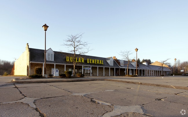
Property Record
919 Cherry St E, Canal Fulton, OH 44614


Property Detail
919 Cherry St E
09503315
OL 162 - 4.80A; OL 163 - 5.93A; OL 164 - .36A
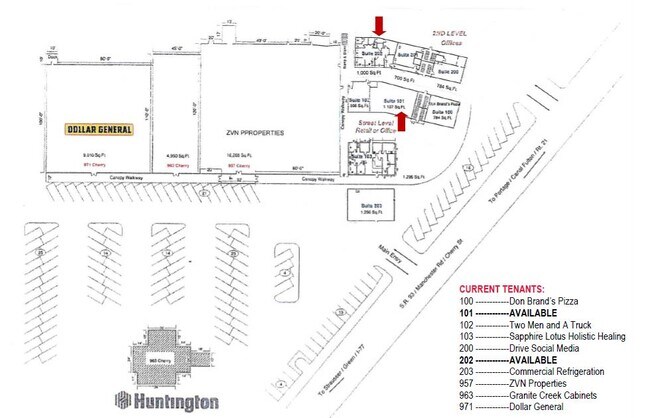
Regionalshoppingcenterormallwithanchorstore
Stark
B and X Area of moderate flood hazard, usually the area between the limits of the 100-year and 500-year floods.
Ohio
0
11.09 AC
2025
Stark County
711211
Cleveland
42,126 SF
Canton-Massillon, OH
NEARBY LISTINGS FOR SALE OR LEASE
DEMOGRAPHICS near 919 Cherry St E
1 mile
3 mile
5 mile
2025 Total Population
5,017
13,758
32,593
2030 Population
4,975
13,688
32,470
Pop Growth 2025-2030
(0.84%)
(0.51%)
(0.38%)
Average Age
44
44
43
2025 Total Households
2,050
5,532
12,593
HH Growth 2025-2030
(0.83%)
(0.51%)
(0.41%)
Median Household Inc
$70,067
$81,577
$90,438
Avg Household Size
2.40
2.40
2.50
2025 Avg HH Vehicles
2.00
2.00
2.00
Median Home Value
$202,457
$216,290
$242,146
Median Year Built
1980
1976
1975
Nearby Places
Map Layers
Map Styles
 Street
 Aerial
Layers
 Traffic
 Biking
Places
Listings with unknown addresses are not visible on the map
- Restaurants
- Banks
- Shops
- Fitness
- Groceries
PUBLIC TRANSPORTATION
AIRPORT
Akron-Canton Regional
Drive
Walk
Distance
Akron-Canton Regional
22 min
11.7 mi
SALE & LEASE HISTORY
LISTING DATE
SALE/LEASE

Sep 25, 2016
For Lease
May 04, 2022
For Lease
May 02, 2022
For Lease
Nearby Properties
Address
Land Use
TOTAL SIZE
Lot Size
Zoning
Address
Land Use
TOTAL SIZE
Lot Size
Zoning
215,826 SF
41.38 AC
Address
Land Use
TOTAL SIZE
Lot Size
Zoning
Address
Land Use
TOTAL SIZE
Lot Size
Zoning
Address
Land Use
TOTAL SIZE
Lot Size
Zoning
Address
Land Use
TOTAL SIZE
Lot Size
Zoning
49,558 SF
328.80 AC
Address
Land Use
TOTAL SIZE
Lot Size
Zoning
110,301 SF
22.70 AC
Address
Land Use
TOTAL SIZE
Lot Size
Zoning
60,420 SF
16.19 AC
Address
Land Use
TOTAL SIZE
Lot Size
Zoning
Address
Land Use
TOTAL SIZE
Lot Size
Zoning
99,887 SF
14.82 AC
Address
Land Use
TOTAL SIZE
Lot Size
Zoning
71,641 SF
31.77 AC
Address
Land Use
TOTAL SIZE
Lot Size
Zoning
Address
Land Use
TOTAL SIZE
Lot Size
Zoning
24,592 SF
3.45 AC
Address
Land Use
TOTAL SIZE
Lot Size
Zoning
115,200 SF
7.20 AC
Address
Land Use
TOTAL SIZE
Lot Size
Zoning
24,914 SF
5.07 AC
Address
Land Use
TOTAL SIZE
Lot Size
Zoning
Address
Land Use
TOTAL SIZE
Lot Size
Zoning
1,988 SF
283.54 AC
Address
Land Use
TOTAL SIZE
Lot Size
Zoning
150,895 SF
31.91 AC
Address
Land Use
TOTAL SIZE
Lot Size
Zoning
10,248 SF
158.32 AC
Address
Land Use
TOTAL SIZE
Lot Size
Zoning
26,914 SF
3.23 AC
Address
Land Use
TOTAL SIZE
Lot Size
Zoning
49,041 SF
16.73 AC
Address
Land Use
TOTAL SIZE
Lot Size
Zoning
111,464 SF
10.90 AC
Address
Land Use
TOTAL SIZE
Lot Size
Zoning
117,773 SF
35.60 AC
Address
Land Use
TOTAL SIZE
Lot Size
Zoning
28,990 SF
4.95 AC
Address
Land Use
TOTAL SIZE
Lot Size
Zoning
28,163 SF
3.32 AC
Address
Land Use
TOTAL SIZE
Lot Size
Zoning
60,000 SF
5.30 AC
Address
Land Use
TOTAL SIZE
Lot Size
Zoning
26,003 SF
2.67 AC
Address
Land Use
TOTAL SIZE
Lot Size
Zoning
7,481 SF
36.98 AC
Address
Land Use
TOTAL SIZE
Lot Size
Zoning
Address
Land Use
TOTAL SIZE
Lot Size
Zoning
2,452 SF
164.95 AC
Address
Land Use
TOTAL SIZE
Lot Size
Zoning
17,112 SF
3.56 AC
The World's #1 Commercial Real Estate Marketplace
Connect with us
© 2026 CoStar Group
The information above has been obtained from sources believed reliable. While we do not doubt its accuracy we have not verified it and make no guarantee, warranty or representation about it. It is your responsibility to independently confirm its accuracy and completeness. Any projections, opinions, assumptions, or estimates used are for example only and do not represent the current or future performance of the property. The value of this transaction to you depends on tax and other factors which should be evaluated by your tax, financial, and legal advisors. You and your advisors should conduct a careful, independent investigation of the property to determine to your satisfaction the suitability of the property for your needs.