Property Record
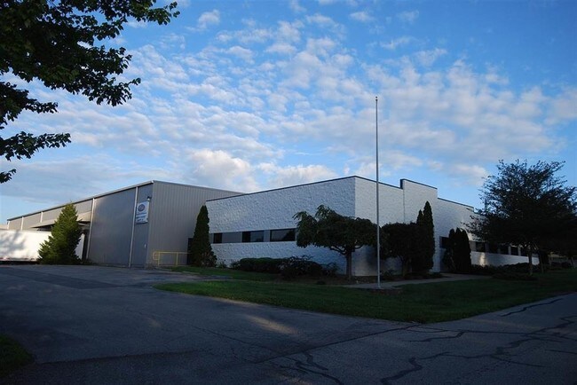
919 E 14Th St, Jasper, IN 47546


Property Detail
919 E 14Th St
19-06-25-302-530.000-002
018-06230-00 PT N 1/2 SW 25-1-5 1.25A
Warehouse
Dubois
B and X Area of moderate flood hazard, usually the area between the limits of the 100-year and 500-year floods.
Indiana
2024
1.25 AC
2025
Other Market Areas
953400
Jasper, IN
1,386 SF
NEARBY LISTINGS FOR SALE OR LEASE
DEMOGRAPHICS near 919 E 14Th St
1 mile
3 mile
5 mile
2025 Total Population
4,003
17,141
20,969
2030 Population
4,013
17,240
21,045
Pop Growth 2025-2030
+ 0.25%
+ 0.58%
+ 0.36%
Average Age
39
41
41
2025 Total Households
1,691
7,124
8,587
HH Growth 2025-2030
+ 0.24%
+ 0.58%
+ 0.40%
Median Household Inc
$61,680
$65,471
$67,713
Avg Household Size
2.30
2.30
2.40
2025 Avg HH Vehicles
2.00
2.00
2.00
Median Home Value
$166,598
$218,344
$239,370
Median Year Built
1958
1983
1984
Nearby Places
Map Layers
Map Styles
 Street
 Aerial
Transit
 Traffic
 Biking
Places
Listings with unknown addresses are not visible on the map
- Restaurants
- Banks
- Shops
- Fitness
- Groceries
SALE & LEASE HISTORY
LISTING DATE
SALE/LEASE

Sep 24, 2016
For Sale
Oct 05, 2017
For Lease
Nearby Properties
Address
Land Use
TOTAL SIZE
Lot Size
Zoning
Address
Land Use
TOTAL SIZE
Lot Size
Zoning
11,840 SF
9.37 AC
Address
Land Use
TOTAL SIZE
Lot Size
Zoning
105,015 SF
2.34 AC
Address
Land Use
TOTAL SIZE
Lot Size
Zoning
86,400 SF
28.06 AC
Address
Land Use
TOTAL SIZE
Lot Size
Zoning
13,448 SF
11.94 AC
Address
Land Use
TOTAL SIZE
Lot Size
Zoning
124,714 SF
6 AC
Address
Land Use
TOTAL SIZE
Lot Size
Zoning
8,760 SF
8.16 AC
Address
Land Use
TOTAL SIZE
Lot Size
Zoning
84,431 SF
16.47 AC
Address
Land Use
TOTAL SIZE
Lot Size
Zoning
63,884 SF
6.50 AC
Address
Land Use
TOTAL SIZE
Lot Size
Zoning
201,669 SF
21.86 AC
Address
Land Use
TOTAL SIZE
Lot Size
Zoning
80,880 SF
18.09 AC
Address
Land Use
TOTAL SIZE
Lot Size
Zoning
52,500 SF
1.52 AC
Address
Land Use
TOTAL SIZE
Lot Size
Zoning
13,724 SF
11.87 AC
Address
Land Use
TOTAL SIZE
Lot Size
Zoning
39,869 SF
3.88 AC
Address
Land Use
TOTAL SIZE
Lot Size
Zoning
39,678 SF
13.50 AC
Address
Land Use
TOTAL SIZE
Lot Size
Zoning
170,849 SF
16.66 AC
Address
Land Use
TOTAL SIZE
Lot Size
Zoning
10,736 SF
2 AC
Address
Land Use
TOTAL SIZE
Lot Size
Zoning
59,732 SF
2.81 AC
Address
Land Use
TOTAL SIZE
Lot Size
Zoning
121,710 SF
7.96 AC
Address
Land Use
TOTAL SIZE
Lot Size
Zoning
12,433 SF
0.89 AC
Address
Land Use
TOTAL SIZE
Lot Size
Zoning
50,205 SF
3.72 AC
Address
Land Use
TOTAL SIZE
Lot Size
Zoning
6,400 SF
1.67 AC
Address
Land Use
TOTAL SIZE
Lot Size
Zoning
56,414 SF
4.53 AC
Address
Land Use
TOTAL SIZE
Lot Size
Zoning
6,372 SF
6.38 AC
Address
Land Use
TOTAL SIZE
Lot Size
Zoning
100,000 SF
8.89 AC
Address
Land Use
TOTAL SIZE
Lot Size
Zoning
10,736 SF
3.39 AC
Address
Land Use
TOTAL SIZE
Lot Size
Zoning
20,724 SF
5.02 AC
Address
Land Use
TOTAL SIZE
Lot Size
Zoning
6,000 SF
4.90 AC
Address
Land Use
TOTAL SIZE
Lot Size
Zoning
71,832 SF
16.76 AC
Address
Land Use
TOTAL SIZE
Lot Size
Zoning
20,400 SF
3 AC
Address
Land Use
TOTAL SIZE
Lot Size
Zoning
88,622 SF
11.98 AC
The World's #1 Commercial Real Estate Marketplace
Connect with us
© 2026 CoStar Group
The information above has been obtained from sources believed reliable. While we do not doubt its accuracy we have not verified it and make no guarantee, warranty or representation about it. It is your responsibility to independently confirm its accuracy and completeness. Any projections, opinions, assumptions, or estimates used are for example only and do not represent the current or future performance of the property. The value of this transaction to you depends on tax and other factors which should be evaluated by your tax, financial, and legal advisors. You and your advisors should conduct a careful, independent investigation of the property to determine to your satisfaction the suitability of the property for your needs.