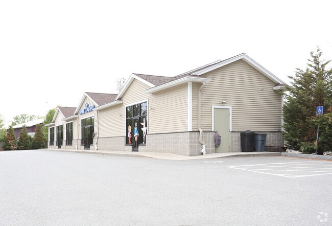
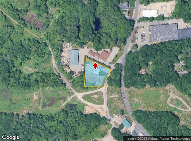
Property Record
919 Main St, Wilmington, MA 01887

NEARBY LISTINGS FOR SALE OR LEASE
Property Detail
919 Main St
Warehouse
Middlesex
X
Massachusetts
25017C0293F
1.09 AC
2025
Wilmington/Reading
2025
Boston
331200
Boston-Cambridge-Newton, MA-NH
2,544 SF
WILM-000025-000000-000000-000003
DEMOGRAPHICS near 919 Main St
1 Mile
3 Mile
5 Mile
2024 Total Population
3,379
68,309
189,369
2029 Population
3,320
67,863
187,709
Pop Growth 2024-2029
(1.75%)
(0.65%)
(0.88%)
Average Age
41
41
42
2024 Total Households
1,239
25,545
72,049
HH Growth 2024-2029
(1.94%)
(0.63%)
(0.94%)
Median Household Inc
$121,114
$128,955
$122,645
Avg Household Size
2.60
2.60
2.60
2024 Avg HH Vehicles
2.00
2.00
2.00
Median Home Value
$666,406
$691,148
$682,545
Median Year Built
1977
1969
1967
Nearby Places
Map Layers
Map Styles
 Street
 Aerial
- Restaurants
- Banks
- Shops
- Fitness
- Groceries
PUBLIC TRANSPORTATION
COMMUTER RAIL
Wilmington (Lowell Line - Massachusetts Bay Transportation Authority Commuter Rail (Purple Line))
DRIVE
WALK
Distance
Wilmington (Lowell Line - Massachusetts Bay Transportation Authority Commuter Rail (Purple Line))
4 min
2.0 mi
Anderson/Woburn Regional Transportation Center (Lowell Line - Massachusetts Bay Transportation Authority Commuter Rail (Purple Line))
DRIVE
WALK
Distance
Anderson/Woburn Regional Transportation Center (Lowell Line - Massachusetts Bay Transportation Authority Commuter Rail (Purple Line))
4 min
2.3 mi
AIRPORT
General Edward Lawrence Logan International
DRIVE
WALK
Distance
General Edward Lawrence Logan International
27 min
18.3 mi
Freight Ports
Port of Boston
DRIVE
WALK
Distance
Port of Boston
28 min
18.1 mi
Nearby Properties
Address
Land Use
TOTAL SIZE
Lot Size
Zoning
Address
Land Use
TOTAL SIZE
Lot Size
Zoning
42.20 AC
S-2
Address
Land Use
TOTAL SIZE
Lot Size
Zoning
196,098 SF
22.41 AC
R20
Address
Land Use
TOTAL SIZE
Lot Size
Zoning
388,978 SF
23.23 AC
RG
Address
Land Use
TOTAL SIZE
Lot Size
Zoning
27.56 AC
R-2
Address
Land Use
TOTAL SIZE
Lot Size
Zoning
476,332 SF
5.37 AC
Address
Land Use
TOTAL SIZE
Lot Size
Zoning
405,606 SF
33.40 AC
RO
Address
Land Use
TOTAL SIZE
Lot Size
Zoning
18.62 AC
O-P
Address
Land Use
TOTAL SIZE
Lot Size
Zoning
346,106 SF
42.04 AC
RO
Address
Land Use
TOTAL SIZE
Lot Size
Zoning
330,500 SF
7.44 AC
PD
Address
Land Use
TOTAL SIZE
Lot Size
Zoning
411,956 SF
23.94 AC
S20
Address
Land Use
TOTAL SIZE
Lot Size
Zoning
30.92 AC
RO
Address
Land Use
TOTAL SIZE
Lot Size
Zoning
275,751 SF
41.30 AC
R20
Address
Land Use
TOTAL SIZE
Lot Size
Zoning
265,827 SF
10.38 AC
IH
Address
Land Use
TOTAL SIZE
Lot Size
Zoning
7.90 AC
PD
Address
Land Use
TOTAL SIZE
Lot Size
Zoning
14.82 AC
RO
Address
Land Use
TOTAL SIZE
Lot Size
Zoning
368,748 SF
40.10 AC
IND
Address
Land Use
TOTAL SIZE
Lot Size
Zoning
9.01 AC
S-I
Address
Land Use
TOTAL SIZE
Lot Size
Zoning
341,593 SF
3.38 AC
I-P2
Address
Land Use
TOTAL SIZE
Lot Size
Zoning
129,028 SF
7.17 AC
I-P2
Address
Land Use
TOTAL SIZE
Lot Size
Zoning
153,906 SF
4 AC
S15
Address
Land Use
TOTAL SIZE
Lot Size
Zoning
27.90 AC
I-P2
Address
Land Use
TOTAL SIZE
Lot Size
Zoning
398,140 SF
39.50 AC
GI
Address
Land Use
TOTAL SIZE
Lot Size
Zoning
17.65 AC
B-I
Address
Land Use
TOTAL SIZE
Lot Size
Zoning
10.73 AC
I-P2
Address
Land Use
TOTAL SIZE
Lot Size
Zoning
19.66 AC
BG
Address
Land Use
TOTAL SIZE
Lot Size
Zoning
216,337 SF
7.19 AC
S20
Address
Land Use
TOTAL SIZE
Lot Size
Zoning
141,968 SF
11.28 AC
R20
Address
Land Use
TOTAL SIZE
Lot Size
Zoning
6.77 AC
I-P2
Address
Land Use
TOTAL SIZE
Lot Size
Zoning
188,538 SF
6.78 AC
BG
Address
Land Use
TOTAL SIZE
Lot Size
Zoning
481,812 SF
25.97 AC
I-P2
The World's #1 Commercial Real Estate Marketplace
Connect with us
© 2025 CoStar Group
The information above has been obtained from sources believed reliable. While we do not doubt its accuracy we have not verified it and make no guarantee, warranty or representation about it. It is your responsibility to independently confirm its accuracy and completeness. Any projections, opinions, assumptions, or estimates used are for example only and do not represent the current or future performance of the property. The value of this transaction to you depends on tax and other factors which should be evaluated by your tax, financial, and legal advisors. You and your advisors should conduct a careful, independent investigation of the property to determine to your satisfaction the suitability of the property for your needs.