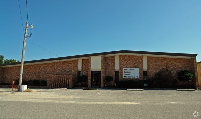
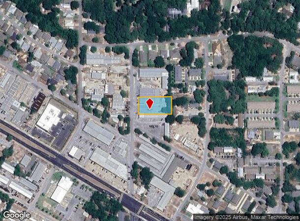
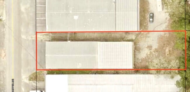
Property Record
919 Skipper Ave, Fort Walton Beach, FL 32547
Current Lease Availabilities
NEARBY LISTINGS FOR SALE OR LEASE
Property Detail
919 Skipper Ave
Crestview-Fort Walton Beach-Destin, FL
Harris S/D
01-2S-24-1120-0001-0040
HARRIS S/D LOTS 4 & 5 BLK 1
Lightindustrial
Okaloosa
X
Florida
12091C0453J
40
2023
0.62 AC
2024
Ocean City
022001
Other Market Areas
20,040 SF
DEMOGRAPHICS near 919 Skipper Ave
1 Mile
3 Mile
5 Mile
2024 Total Population
7,611
55,078
75,718
2029 Population
7,915
57,203
79,564
Pop Growth 2024-2029
+ 3.99%
+ 3.86%
+ 5.08%
Average Age
40
40
40
2024 Total Households
3,199
23,078
32,171
HH Growth 2024-2029
+ 3.91%
+ 3.69%
+ 5.23%
Median Household Inc
$56,230
$59,462
$60,906
Avg Household Size
2.30
2.30
2.30
2024 Avg HH Vehicles
2.00
2.00
2.00
Median Home Value
$290,346
$272,605
$280,570
Median Year Built
1972
1980
1981
Nearby Places
- Restaurants
- Banks
- Shops
- Fitness
- Groceries
PUBLIC TRANSPORTATION
AIRPORT
Eglin AFB/Destin-Ft Walton Beach
DRIVE
WALK
Distance
Eglin AFB/Destin-Ft Walton Beach
26 min
8.7 mi
Pensacola International
DRIVE
WALK
Distance
Pensacola International
82 min
47.7 mi
Nearby Properties
Address
Land Use
TOTAL SIZE
Lot Size
Zoning
Address
Land Use
TOTAL SIZE
Lot Size
Zoning
71,584 SF
3 AC
Address
Land Use
TOTAL SIZE
Lot Size
Zoning
117,852 SF
13.39 AC
Address
Land Use
TOTAL SIZE
Lot Size
Zoning
560,800 SF
126.12 AC
Address
Land Use
TOTAL SIZE
Lot Size
Zoning
342,628 SF
14.83 AC
Address
Land Use
TOTAL SIZE
Lot Size
Zoning
120,159 SF
14.82 AC
Address
Land Use
TOTAL SIZE
Lot Size
Zoning
295,771 SF
18.52 AC
Address
Land Use
TOTAL SIZE
Lot Size
Zoning
48,449 SF
3.99 AC
Address
Land Use
TOTAL SIZE
Lot Size
Zoning
15.37 AC
Address
Land Use
TOTAL SIZE
Lot Size
Zoning
432.78 AC
Address
Land Use
TOTAL SIZE
Lot Size
Zoning
73,434 SF
2.40 AC
Address
Land Use
TOTAL SIZE
Lot Size
Zoning
85,571 SF
4.54 AC
Address
Land Use
TOTAL SIZE
Lot Size
Zoning
227,975 SF
24.24 AC
Address
Land Use
TOTAL SIZE
Lot Size
Zoning
128,844 SF
4.86 AC
Address
Land Use
TOTAL SIZE
Lot Size
Zoning
563.23 AC
Address
Land Use
TOTAL SIZE
Lot Size
Zoning
59,257 SF
2.99 AC
Address
Land Use
TOTAL SIZE
Lot Size
Zoning
51,030 SF
1.82 AC
Address
Land Use
TOTAL SIZE
Lot Size
Zoning
182,844 SF
20.62 AC
Address
Land Use
TOTAL SIZE
Lot Size
Zoning
68,966 SF
6.03 AC
Address
Land Use
TOTAL SIZE
Lot Size
Zoning
140,945 SF
80.64 AC
Address
Land Use
TOTAL SIZE
Lot Size
Zoning
108,284 SF
5.47 AC
Address
Land Use
TOTAL SIZE
Lot Size
Zoning
88,509 SF
4.73 AC
Address
Land Use
TOTAL SIZE
Lot Size
Zoning
216,395 SF
4.99 AC
Address
Land Use
TOTAL SIZE
Lot Size
Zoning
70,119 SF
2.98 AC
Address
Land Use
TOTAL SIZE
Lot Size
Zoning
78,958 SF
7.88 AC
Address
Land Use
TOTAL SIZE
Lot Size
Zoning
56,833 SF
1.37 AC
Address
Land Use
TOTAL SIZE
Lot Size
Zoning
71,050 SF
2.52 AC
Address
Land Use
TOTAL SIZE
Lot Size
Zoning
79,960 SF
0.96 AC
Address
Land Use
TOTAL SIZE
Lot Size
Zoning
229,805 SF
19.31 AC
Address
Land Use
TOTAL SIZE
Lot Size
Zoning
146,143 SF
19.39 AC
Address
Land Use
TOTAL SIZE
Lot Size
Zoning
61,445 SF
3.47 AC
The World's #1 Commercial Real Estate Marketplace
Connect with us
© 2025 CoStar Group
The information above has been obtained from sources believed reliable. While we do not doubt its accuracy we have not verified it and make no guarantee, warranty or representation about it. It is your responsibility to independently confirm its accuracy and completeness. Any projections, opinions, assumptions, or estimates used are for example only and do not represent the current or future performance of the property. The value of this transaction to you depends on tax and other factors which should be evaluated by your tax, financial, and legal advisors. You and your advisors should conduct a careful, independent investigation of the property to determine to your satisfaction the suitability of the property for your needs.