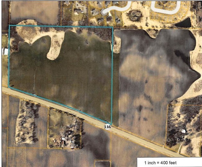
Property Record
92 Address Unassigned, Rogers, MN 55374


NEARBY LISTINGS FOR SALE OR LEASE
Property Detail
92 Address Unassigned
22-120-23-33-0006
Unplatted 22 120 23
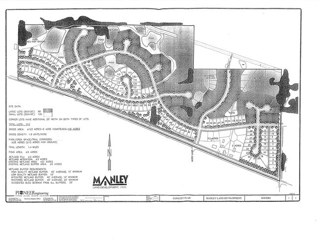
Farms
UNPLATTED 22 120 23 THAT PART OF SW 1/4 OF SW 1/4 OF SEC 22 T 120 R 23 LYING N OF ROAD IRREGULAR
X
Hennepin
27053C0040F
Minnesota
2024
30.32 AC
2024
Northwest
026912
Minneapolis/St Paul
3,860 SF
Minneapolis-St. Paul-Bloomington, MN-WI
DEMOGRAPHICS near 92 Address Unassigned
1 Mile
3 Mile
5 Mile
2024 Total Population
2,102
14,242
42,718
2029 Population
2,065
14,308
45,314
Pop Growth 2024-2029
(1.76%)
+ 0.46%
+ 6.08%
Average Age
37
38
37
2024 Total Households
713
4,814
14,491
HH Growth 2024-2029
(1.96%)
+ 0.33%
+ 5.95%
Median Household Inc
$122,195
$130,814
$123,857
Avg Household Size
2.90
2.90
2.90
2024 Avg HH Vehicles
2.00
2.00
2.00
Median Home Value
$363,390
$374,844
$369,413
Median Year Built
1997
2000
2001
Nearby Places
Map Layers
Map Styles
 Street
 Aerial
- Restaurants
- Banks
- Shops
- Fitness
- Groceries
PUBLIC TRANSPORTATION
AIRPORT
Minneapolis-St Paul International/Wold-Chamberlain
DRIVE
WALK
Distance
Minneapolis-St Paul International/Wold-Chamberlain
51 min
36.3 mi
Freight Ports
Port Milwaukee
DRIVE
WALK
Distance
Port Milwaukee
403 min
361.5 mi
SALE & LEASE HISTORY
LISTING DATE
SALE/LEASE

May 01, 2017
For Sale
Nearby Properties
Address
Land Use
TOTAL SIZE
Lot Size
Zoning
Address
Land Use
TOTAL SIZE
Lot Size
Zoning
42.21 AC
Address
Land Use
TOTAL SIZE
Lot Size
Zoning
36.67 AC
Address
Land Use
TOTAL SIZE
Lot Size
Zoning
21.50 AC
Address
Land Use
TOTAL SIZE
Lot Size
Zoning
30.13 AC
Address
Land Use
TOTAL SIZE
Lot Size
Zoning
Address
Land Use
TOTAL SIZE
Lot Size
Zoning
62.34 AC
Address
Land Use
TOTAL SIZE
Lot Size
Zoning
30.91 AC
Address
Land Use
TOTAL SIZE
Lot Size
Zoning
15.15 AC
Address
Land Use
TOTAL SIZE
Lot Size
Zoning
20.09 AC
Address
Land Use
TOTAL SIZE
Lot Size
Zoning
13.21 AC
Address
Land Use
TOTAL SIZE
Lot Size
Zoning
10.26 AC
Address
Land Use
TOTAL SIZE
Lot Size
Zoning
Address
Land Use
TOTAL SIZE
Lot Size
Zoning
11.44 AC
Address
Land Use
TOTAL SIZE
Lot Size
Zoning
41.53 AC
Address
Land Use
TOTAL SIZE
Lot Size
Zoning
10.01 AC
Address
Land Use
TOTAL SIZE
Lot Size
Zoning
7.59 AC
Address
Land Use
TOTAL SIZE
Lot Size
Zoning
1,848 SF
13.94 AC
Address
Land Use
TOTAL SIZE
Lot Size
Zoning
Address
Land Use
TOTAL SIZE
Lot Size
Zoning
Address
Land Use
TOTAL SIZE
Lot Size
Zoning
10.27 AC
Address
Land Use
TOTAL SIZE
Lot Size
Zoning
12.15 AC
Address
Land Use
TOTAL SIZE
Lot Size
Zoning
Address
Land Use
TOTAL SIZE
Lot Size
Zoning
Address
Land Use
TOTAL SIZE
Lot Size
Zoning
14.56 AC
Address
Land Use
TOTAL SIZE
Lot Size
Zoning
1,608 SF
21.77 AC
Address
Land Use
TOTAL SIZE
Lot Size
Zoning
13.37 AC
Address
Land Use
TOTAL SIZE
Lot Size
Zoning
43.23 AC
Address
Land Use
TOTAL SIZE
Lot Size
Zoning
Address
Land Use
TOTAL SIZE
Lot Size
Zoning
Address
Land Use
TOTAL SIZE
Lot Size
Zoning
The World's #1 Commercial Real Estate Marketplace
Connect with us
© 2026 CoStar Group
The information above has been obtained from sources believed reliable. While we do not doubt its accuracy we have not verified it and make no guarantee, warranty or representation about it. It is your responsibility to independently confirm its accuracy and completeness. Any projections, opinions, assumptions, or estimates used are for example only and do not represent the current or future performance of the property. The value of this transaction to you depends on tax and other factors which should be evaluated by your tax, financial, and legal advisors. You and your advisors should conduct a careful, independent investigation of the property to determine to your satisfaction the suitability of the property for your needs.