Property Record
92 Mansfield Ave, Norton, MA 02766
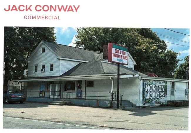

This Property Is For Sale
Current Lease Availabilities
Property Detail
92 Mansfield Ave
NORT-000016-000000-000141
Bristol
Commercialofficeresidentialmixeduse
Massachusetts
A Areas with a 1% annual chance of flooding and a 26% chance of flooding over the life of a 30-year mortgage.
0.37 AC
2025
Attleboro/New Bedford
2025
Boston
611102
Providence-Warwick, RI-MA
3,890 SF
NEARBY LISTINGS FOR SALE OR LEASE
DEMOGRAPHICS near 92 Mansfield Ave
1 mile
3 mile
5 mile
2025 Total Population
3,727
21,510
73,768
2030 Population
3,809
21,914
75,381
Pop Growth 2025-2030
+ 2.20%
+ 1.88%
+ 2.19%
Average Age
41
41
41
2025 Total Households
1,175
7,551
27,521
HH Growth 2025-2030
+ 2.81%
+ 2.08%
+ 2.29%
Median Household Inc
$111,255
$128,356
$117,518
Avg Household Size
2.30
2.60
2.60
2025 Avg HH Vehicles
2.00
2.00
2.00
Median Home Value
$451,736
$572,813
$557,463
Median Year Built
1981
1982
1979
Nearby Places
Map Layers
Map Styles
 Street
 Aerial
Layers
 Traffic
 Biking
Places
Listings with unknown addresses are not visible on the map
- Restaurants
- Banks
- Shops
- Fitness
- Groceries
PUBLIC TRANSPORTATION
COMMUTER RAIL
Mansfield (Foxboro Line (Special Events Only) - Massachusetts Bay Transportation Authority Commuter Rail (Purple Line), Providence/Stoughton Line - Massachusetts Bay Transportation Authority Commuter Rail (Purple Line))
Drive
Walk
Distance
Mansfield (Foxboro Line (Special Events Only) - Massachusetts Bay Transportation Authority Commuter Rail (Purple Line), Providence/Stoughton Line - Massachusetts Bay Transportation Authority Commuter Rail (Purple Line))
11 min
5.5 mi
Attleboro (Foxboro Event Service - MBTA, Providence/Stoughton Line - MBTA)
Drive
Walk
Distance
Attleboro (Foxboro Event Service - MBTA, Providence/Stoughton Line - MBTA)
12 min
6.8 mi
AIRPORT
Rhode Island Tf Green International
Drive
Walk
Distance
Rhode Island Tf Green International
45 min
27.8 mi
General Edward Lawrence Logan International
Drive
Walk
Distance
General Edward Lawrence Logan International
55 min
38.3 mi
Freight Ports
Port of Boston
Drive
Walk
Distance
Port of Boston
52 min
32.8 mi
Nearby Properties
Address
Land Use
TOTAL SIZE
Lot Size
Zoning
Address
Land Use
TOTAL SIZE
Lot Size
Zoning
351,950 SF
31.45 AC
Address
Land Use
TOTAL SIZE
Lot Size
Zoning
3,838 SF
1.11 AC
R80
Address
Land Use
TOTAL SIZE
Lot Size
Zoning
223,480 SF
37.59 AC
Address
Land Use
TOTAL SIZE
Lot Size
Zoning
Address
Land Use
TOTAL SIZE
Lot Size
Zoning
177,218 SF
50.82 AC
Address
Land Use
TOTAL SIZE
Lot Size
Zoning
225,600 SF
18.47 AC
R80
Address
Land Use
TOTAL SIZE
Lot Size
Zoning
212,672 SF
34.40 AC
Address
Land Use
TOTAL SIZE
Lot Size
Zoning
26.34 AC
Address
Land Use
TOTAL SIZE
Lot Size
Zoning
123,740 SF
10.67 AC
R80
Address
Land Use
TOTAL SIZE
Lot Size
Zoning
26.70 AC
Address
Land Use
TOTAL SIZE
Lot Size
Zoning
82,828 SF
15.45 AC
Address
Land Use
TOTAL SIZE
Lot Size
Zoning
82,946 SF
25.50 AC
Address
Land Use
TOTAL SIZE
Lot Size
Zoning
358.70 AC
Address
Land Use
TOTAL SIZE
Lot Size
Zoning
6.30 AC
Address
Land Use
TOTAL SIZE
Lot Size
Zoning
106.27 AC
Address
Land Use
TOTAL SIZE
Lot Size
Zoning
3,153 SF
53 AC
Address
Land Use
TOTAL SIZE
Lot Size
Zoning
15.28 AC
Address
Land Use
TOTAL SIZE
Lot Size
Zoning
64.80 AC
Address
Land Use
TOTAL SIZE
Lot Size
Zoning
113,173 SF
4.52 AC
R60
Address
Land Use
TOTAL SIZE
Lot Size
Zoning
113,671 SF
13.13 AC
Address
Land Use
TOTAL SIZE
Lot Size
Zoning
44,372 SF
36 AC
Address
Land Use
TOTAL SIZE
Lot Size
Zoning
99,960 SF
6.81 AC
Address
Land Use
TOTAL SIZE
Lot Size
Zoning
36,074 SF
5.20 AC
Address
Land Use
TOTAL SIZE
Lot Size
Zoning
60,000 SF
22.76 AC
Address
Land Use
TOTAL SIZE
Lot Size
Zoning
99,458 SF
16 AC
R80
Address
Land Use
TOTAL SIZE
Lot Size
Zoning
10.94 AC
Address
Land Use
TOTAL SIZE
Lot Size
Zoning
Address
Land Use
TOTAL SIZE
Lot Size
Zoning
56,360 SF
5.84 AC
Address
Land Use
TOTAL SIZE
Lot Size
Zoning
44,731 SF
0.51 AC
R60
Address
Land Use
TOTAL SIZE
Lot Size
Zoning
5.09 AC
The World's #1 Commercial Real Estate Marketplace
Connect with us
© 2026 CoStar Group
The information above has been obtained from sources believed reliable. While we do not doubt its accuracy we have not verified it and make no guarantee, warranty or representation about it. It is your responsibility to independently confirm its accuracy and completeness. Any projections, opinions, assumptions, or estimates used are for example only and do not represent the current or future performance of the property. The value of this transaction to you depends on tax and other factors which should be evaluated by your tax, financial, and legal advisors. You and your advisors should conduct a careful, independent investigation of the property to determine to your satisfaction the suitability of the property for your needs.