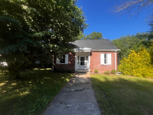
Property Record
92 N Main St, Pascoag, RI 02859

Property Detail
92 N Main St
BURR-000158-000000-000081
Providence
Commercialbuilding
Rhode Island
VC
81
C and X Area of minimal flood hazard, usually depicted on FIRMs as above the 500-year flood level.
0.16 AC
2025
Burrillville/Glocester
2025
Providence
012900
Providence-Warwick, RI-MA
708 SF
NEARBY LISTINGS FOR SALE OR LEASE
-
-
View all Pascoag listings for sale on LoopNet.com
DEMOGRAPHICS near 92 N Main St
1 mile
3 mile
5 mile
2025 Total Population
4,659
13,944
23,230
2030 Population
4,900
14,670
24,372
Pop Growth 2025-2030
+ 5.17%
+ 5.21%
+ 4.92%
Average Age
41
43
43
2025 Total Households
1,841
5,449
8,953
HH Growth 2025-2030
+ 5.16%
+ 5.23%
+ 4.95%
Median Household Inc
$100,136
$104,288
$112,077
Avg Household Size
2.40
2.50
2.50
2025 Avg HH Vehicles
2.00
2.00
2.00
Median Home Value
$394,821
$404,814
$423,344
Median Year Built
1955
1968
1973
Nearby Places
Map Layers
Map Styles
 Street
 Aerial
Layers
 Traffic
 Biking
Places
Listings with unknown addresses are not visible on the map
- Restaurants
- Banks
- Shops
- Fitness
- Groceries
PUBLIC TRANSPORTATION
AIRPORT
Rhode Island Tf Green International
Drive
Walk
Distance
Rhode Island Tf Green International
44 min
26.9 mi
Worcester Regional
Drive
Walk
Distance
Worcester Regional
51 min
33.4 mi
SALE & LEASE HISTORY
LISTING DATE
SALE/LEASE

Jun 24, 2024
For Sale
Nearby Properties
Address
Land Use
TOTAL SIZE
Lot Size
Zoning
Address
Land Use
TOTAL SIZE
Lot Size
Zoning
64.77 AC
GI
Address
Land Use
TOTAL SIZE
Lot Size
Zoning
10.43 AC
R20
Address
Land Use
TOTAL SIZE
Lot Size
Zoning
192.38 AC
R20
Address
Land Use
TOTAL SIZE
Lot Size
Zoning
85,200 SF
3.86 AC
VC
Address
Land Use
TOTAL SIZE
Lot Size
Zoning
42,504 SF
10.35 AC
R40
Address
Land Use
TOTAL SIZE
Lot Size
Zoning
151,584 SF
7.61 AC
GI
Address
Land Use
TOTAL SIZE
Lot Size
Zoning
66,069 SF
2.28 AC
VCVP
Address
Land Use
TOTAL SIZE
Lot Size
Zoning
23,937 SF
2.34 AC
VCVP
Address
Land Use
TOTAL SIZE
Lot Size
Zoning
5,011 SF
6.98 AC
R12
Address
Land Use
TOTAL SIZE
Lot Size
Zoning
48,902 SF
4.35 AC
VCVP
Address
Land Use
TOTAL SIZE
Lot Size
Zoning
44.16 AC
GI
Address
Land Use
TOTAL SIZE
Lot Size
Zoning
43,999 SF
7.79 AC
GI
Address
Land Use
TOTAL SIZE
Lot Size
Zoning
38,796 SF
1.33 AC
VC
Address
Land Use
TOTAL SIZE
Lot Size
Zoning
14,239 SF
186.15 AC
R40
Address
Land Use
TOTAL SIZE
Lot Size
Zoning
41,420 SF
2.90 AC
R12
Address
Land Use
TOTAL SIZE
Lot Size
Zoning
40,110 SF
6.49 AC
VC
Address
Land Use
TOTAL SIZE
Lot Size
Zoning
29,668 SF
1.18 AC
GI
Address
Land Use
TOTAL SIZE
Lot Size
Zoning
52,200 SF
3.44 AC
GI
Address
Land Use
TOTAL SIZE
Lot Size
Zoning
6.93 AC
GC
Address
Land Use
TOTAL SIZE
Lot Size
Zoning
0.97 AC
R12
Address
Land Use
TOTAL SIZE
Lot Size
Zoning
40,767 SF
32.40 AC
R40
Address
Land Use
TOTAL SIZE
Lot Size
Zoning
2,772 SF
230.76 AC
F5
Address
Land Use
TOTAL SIZE
Lot Size
Zoning
125.50 AC
F5
Address
Land Use
TOTAL SIZE
Lot Size
Zoning
10,775 SF
2.27 AC
VC
Address
Land Use
TOTAL SIZE
Lot Size
Zoning
68.30 AC
GI
Address
Land Use
TOTAL SIZE
Lot Size
Zoning
26,354 SF
6.89 AC
VC
Address
Land Use
TOTAL SIZE
Lot Size
Zoning
31,659 SF
21.32 AC
GI
Address
Land Use
TOTAL SIZE
Lot Size
Zoning
32,840 SF
1.84 AC
GI
Address
Land Use
TOTAL SIZE
Lot Size
Zoning
8.74 AC
GC
Address
Land Use
TOTAL SIZE
Lot Size
Zoning
42.69 AC
GI
The World's #1 Commercial Real Estate Marketplace
Connect with us
© 2026 CoStar Group
The information above has been obtained from sources believed reliable. While we do not doubt its accuracy we have not verified it and make no guarantee, warranty or representation about it. It is your responsibility to independently confirm its accuracy and completeness. Any projections, opinions, assumptions, or estimates used are for example only and do not represent the current or future performance of the property. The value of this transaction to you depends on tax and other factors which should be evaluated by your tax, financial, and legal advisors. You and your advisors should conduct a careful, independent investigation of the property to determine to your satisfaction the suitability of the property for your needs.