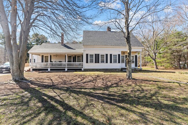
Property Record
92 N Main St, Raynham, MA 02767


Property Detail
92 N Main St
RAYN-000011-000236
Bristol
Commercialofficeresidentialmixeduse
Massachusetts
B and X Area of moderate flood hazard, usually the area between the limits of the 100-year and 500-year floods.
1.09 AC
0
Attleboro/New Bedford
2025
Boston
612201
Providence-Warwick, RI-MA
2,967 SF
NEARBY LISTINGS FOR SALE OR LEASE
DEMOGRAPHICS near 92 N Main St
1 mile
3 mile
5 mile
2025 Total Population
2,579
41,648
79,899
2030 Population
2,636
42,502
81,286
Pop Growth 2025-2030
+ 2.21%
+ 2.05%
+ 1.74%
Average Age
43
41
41
2025 Total Households
969
16,395
31,159
HH Growth 2025-2030
+ 2.27%
+ 2.06%
+ 1.76%
Median Household Inc
$115,460
$82,988
$82,579
Avg Household Size
2.60
2.50
2.50
2025 Avg HH Vehicles
2.00
2.00
2.00
Median Home Value
$594,988
$471,732
$463,016
Median Year Built
1974
1970
1973
Nearby Places
Map Layers
Map Styles
 Street
 Aerial
Transit
 Traffic
 Biking
Places
Listings with unknown addresses are not visible on the map
- Restaurants
- Banks
- Shops
- Fitness
- Groceries
PUBLIC TRANSPORTATION
COMMUTER RAIL
Bridgewater (Middleborough/Lakeville Line - Massachusetts Bay Transportation Authority Commuter Rail (Purple Line))
Drive
Walk
Distance
Bridgewater (Middleborough/Lakeville Line - Massachusetts Bay Transportation Authority Commuter Rail (Purple Line))
17 min
8.1 mi
Middleborough/Lakeville (Middleborough/Lakeville Line - Massachusetts Bay Transportation Authority Commuter Rail (Purple Line))
Drive
Walk
Distance
Middleborough/Lakeville (Middleborough/Lakeville Line - Massachusetts Bay Transportation Authority Commuter Rail (Purple Line))
17 min
9.2 mi
AIRPORT
Rhode Island Tf Green International
Drive
Walk
Distance
Rhode Island Tf Green International
49 min
28.5 mi
Freight Ports
Port of New Bedford Harbor
Drive
Walk
Distance
Port of New Bedford Harbor
35 min
24.6 mi
SALE & LEASE HISTORY
LISTING DATE
SALE/LEASE

Jan 14, 2025
For Lease
Apr 18, 2025
For Sale
Nearby Properties
Address
Land Use
TOTAL SIZE
Lot Size
Zoning
Address
Land Use
TOTAL SIZE
Lot Size
Zoning
279,756 SF
11.62 AC
OFFDIS
Address
Land Use
TOTAL SIZE
Lot Size
Zoning
0.78 AC
Address
Land Use
TOTAL SIZE
Lot Size
Zoning
24.34 AC
Address
Land Use
TOTAL SIZE
Lot Size
Zoning
133,652 SF
2 AC
Address
Land Use
TOTAL SIZE
Lot Size
Zoning
147,285 SF
0.79 AC
CENBIZ
Address
Land Use
TOTAL SIZE
Lot Size
Zoning
157.20 AC
OPSPAC
Address
Land Use
TOTAL SIZE
Lot Size
Zoning
Address
Land Use
TOTAL SIZE
Lot Size
Zoning
87,591 SF
19.83 AC
Address
Land Use
TOTAL SIZE
Lot Size
Zoning
149,234 SF
40.69 AC
Address
Land Use
TOTAL SIZE
Lot Size
Zoning
136,122 SF
49.49 AC
Address
Land Use
TOTAL SIZE
Lot Size
Zoning
100,000 SF
24.80 AC
Address
Land Use
TOTAL SIZE
Lot Size
Zoning
39,910 SF
1.05 AC
CENBIZ
Address
Land Use
TOTAL SIZE
Lot Size
Zoning
14.43 AC
Address
Land Use
TOTAL SIZE
Lot Size
Zoning
137,710 SF
26.66 AC
Address
Land Use
TOTAL SIZE
Lot Size
Zoning
45,786 SF
16 AC
URBRES
Address
Land Use
TOTAL SIZE
Lot Size
Zoning
206,139 SF
21.55 AC
Address
Land Use
TOTAL SIZE
Lot Size
Zoning
8,000 SF
22.31 AC
Address
Land Use
TOTAL SIZE
Lot Size
Zoning
1,783 SF
9.29 AC
Address
Land Use
TOTAL SIZE
Lot Size
Zoning
61,128 SF
0.98 AC
Address
Land Use
TOTAL SIZE
Lot Size
Zoning
107,794 SF
12.51 AC
Address
Land Use
TOTAL SIZE
Lot Size
Zoning
96,208 SF
1.70 AC
URBRES
Address
Land Use
TOTAL SIZE
Lot Size
Zoning
5.60 AC
INDUST
Address
Land Use
TOTAL SIZE
Lot Size
Zoning
76,332 SF
6.20 AC
Address
Land Use
TOTAL SIZE
Lot Size
Zoning
152,070 SF
26.26 AC
Address
Land Use
TOTAL SIZE
Lot Size
Zoning
133,773 SF
24.50 AC
Address
Land Use
TOTAL SIZE
Lot Size
Zoning
5 AC
OFFDIS
Address
Land Use
TOTAL SIZE
Lot Size
Zoning
79,144 SF
5.30 AC
Address
Land Use
TOTAL SIZE
Lot Size
Zoning
164,658 SF
15.18 AC
BIZDIS
Address
Land Use
TOTAL SIZE
Lot Size
Zoning
11.82 AC
URBRES
Address
Land Use
TOTAL SIZE
Lot Size
Zoning
61,360 SF
5.10 AC
The World's #1 Commercial Real Estate Marketplace
Connect with us
© 2026 CoStar Group
The information above has been obtained from sources believed reliable. While we do not doubt its accuracy we have not verified it and make no guarantee, warranty or representation about it. It is your responsibility to independently confirm its accuracy and completeness. Any projections, opinions, assumptions, or estimates used are for example only and do not represent the current or future performance of the property. The value of this transaction to you depends on tax and other factors which should be evaluated by your tax, financial, and legal advisors. You and your advisors should conduct a careful, independent investigation of the property to determine to your satisfaction the suitability of the property for your needs.