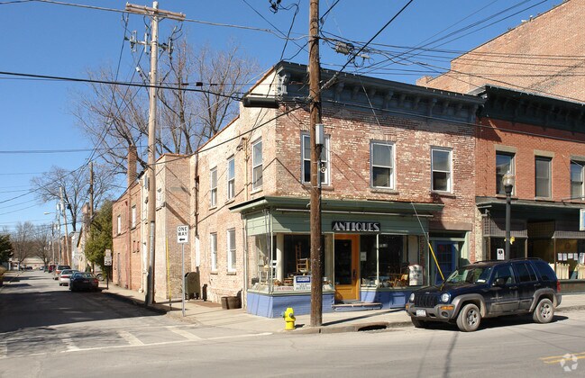
Property Record
92 Partition St, Saugerties, NY 12477
NEARBY LISTINGS FOR SALE OR LEASE
Property Detail
92 Partition St
4801-018.263-0002-021.000-0000
Ulster
Commercialofficeresidentialmixeduse
New York
X
21.000
36111C0305E
0.10 AC
2025
Hudson Valley Area
2024
Other Market Areas
950200
Kingston, NY
4,827 SF
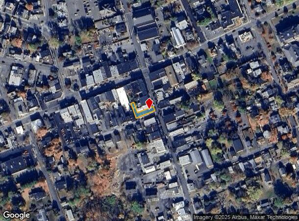
DEMOGRAPHICS near 92 Partition St
1 Mile
3 Mile
5 Mile
2024 Total Population
4,635
11,847
20,570
2029 Population
4,631
11,729
20,513
Pop Growth 2024-2029
(0.09%)
(1.00%)
(0.28%)
Average Age
44
44
45
2024 Total Households
2,125
5,204
8,827
HH Growth 2024-2029
(0.05%)
(0.96%)
(0.27%)
Median Household Inc
$57,448
$63,937
$73,724
Avg Household Size
2.10
2.20
2.30
2024 Avg HH Vehicles
1.00
2.00
2.00
Median Home Value
$310,193
$288,858
$306,337
Median Year Built
1948
1960
1963
Nearby Places
- Restaurants
- Banks
- Shops
- Fitness
- Groceries
Nearby Properties
Address
Land Use
TOTAL SIZE
Lot Size
Zoning
Address
Land Use
TOTAL SIZE
Lot Size
Zoning
183,246 SF
42.20 AC
02 - SINGL
Address
Land Use
TOTAL SIZE
Lot Size
Zoning
12,489 SF
15.10 AC
02 - SINGL
Address
Land Use
TOTAL SIZE
Lot Size
Zoning
19.70 AC
04
Address
Land Use
TOTAL SIZE
Lot Size
Zoning
31,824 SF
84 AC
LDR
Address
Land Use
TOTAL SIZE
Lot Size
Zoning
7.90 AC
03 - MULTI
Address
Land Use
TOTAL SIZE
Lot Size
Zoning
7,994 SF
13.70 AC
23
Address
Land Use
TOTAL SIZE
Lot Size
Zoning
54,461 SF
2.50 AC
03 - MULTI
Address
Land Use
TOTAL SIZE
Lot Size
Zoning
45,441 SF
4.80 AC
05 - COMME
Address
Land Use
TOTAL SIZE
Lot Size
Zoning
77,033 SF
7.40 AC
05 - COMME
Address
Land Use
TOTAL SIZE
Lot Size
Zoning
41,213 SF
7.90 AC
02
Address
Land Use
TOTAL SIZE
Lot Size
Zoning
2,548 SF
8 AC
05 - COMME
Address
Land Use
TOTAL SIZE
Lot Size
Zoning
56,845 SF
17.70 AC
02 - SINGL
Address
Land Use
TOTAL SIZE
Lot Size
Zoning
48,670 SF
10.10 AC
05 - COMME
Address
Land Use
TOTAL SIZE
Lot Size
Zoning
21.70 AC
LC
Address
Land Use
TOTAL SIZE
Lot Size
Zoning
36,004 SF
7.10 AC
05 - COMME
Address
Land Use
TOTAL SIZE
Lot Size
Zoning
33.30 AC
04 - FARM
Address
Land Use
TOTAL SIZE
Lot Size
Zoning
47,688 SF
5.55 AC
05 - COMME
Address
Land Use
TOTAL SIZE
Lot Size
Zoning
13.90 AC
WC
Address
Land Use
TOTAL SIZE
Lot Size
Zoning
81,250 SF
17.50 AC
06 - INDUS
Address
Land Use
TOTAL SIZE
Lot Size
Zoning
5,664 SF
5.30 AC
WC
Address
Land Use
TOTAL SIZE
Lot Size
Zoning
37,032 SF
0.89 AC
07 - MIXED
Address
Land Use
TOTAL SIZE
Lot Size
Zoning
2,400 SF
260.30 AC
RLD
Address
Land Use
TOTAL SIZE
Lot Size
Zoning
2,232 SF
82.20 AC
02 - SINGL
Address
Land Use
TOTAL SIZE
Lot Size
Zoning
9,524 SF
3.30 AC
02 - SINGL
Address
Land Use
TOTAL SIZE
Lot Size
Zoning
13,066 SF
149 AC
Address
Land Use
TOTAL SIZE
Lot Size
Zoning
561.60 AC
05 - COMME
Address
Land Use
TOTAL SIZE
Lot Size
Zoning
32,730 SF
9.70 AC
04 - FARM
Address
Land Use
TOTAL SIZE
Lot Size
Zoning
37,172 SF
10.10 AC
06 - INDUS
Address
Land Use
TOTAL SIZE
Lot Size
Zoning
18,225 SF
29.30 AC
02 - SINGL
Address
Land Use
TOTAL SIZE
Lot Size
Zoning
125.80 AC
04 - FARM
The World's #1 Commercial Real Estate Marketplace
Connect with us
© 2025 CoStar Group
The information above has been obtained from sources believed reliable. While we do not doubt its accuracy we have not verified it and make no guarantee, warranty or representation about it. It is your responsibility to independently confirm its accuracy and completeness. Any projections, opinions, assumptions, or estimates used are for example only and do not represent the current or future performance of the property. The value of this transaction to you depends on tax and other factors which should be evaluated by your tax, financial, and legal advisors. You and your advisors should conduct a careful, independent investigation of the property to determine to your satisfaction the suitability of the property for your needs.