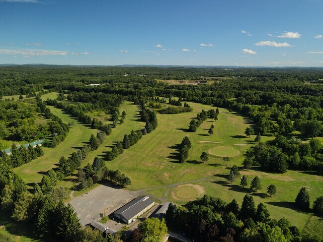
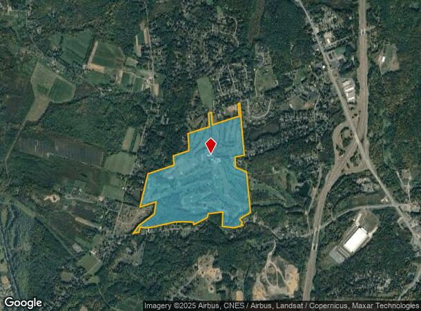
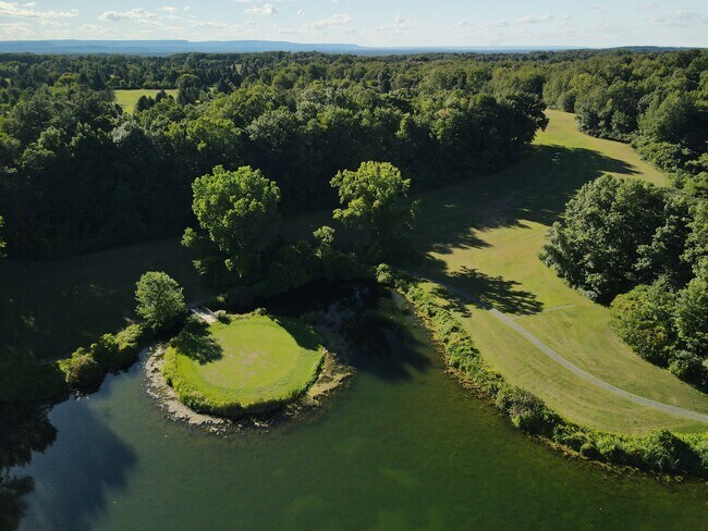
Property Record
92 Schuurman Rd, Castleton On Hudson, NY 12033
NEARBY LISTINGS FOR SALE OR LEASE
Property Detail
92 Schuurman Rd
4489-188-5-5.11
EVERGREEN
Countryclub
Rensselaer
ARE
New York
36083C0362D
5.111
2025
206.90 AC
2024
Outer Rensselaer County
052501
Albany/Schenectady/Troy
12,826 SF
Albany-Schenectady-Troy, NY
DEMOGRAPHICS near 92 Schuurman Rd
1 Mile
3 Mile
5 Mile
2024 Total Population
1,454
11,615
26,764
2029 Population
1,442
11,523
26,507
Pop Growth 2024-2029
(0.83%)
(0.79%)
(0.96%)
Average Age
45
44
44
2024 Total Households
578
4,846
11,190
HH Growth 2024-2029
(0.87%)
(0.93%)
(1.08%)
Median Household Inc
$112,884
$103,619
$96,019
Avg Household Size
2.40
2.40
2.30
2024 Avg HH Vehicles
2.00
2.00
2.00
Median Home Value
$280,973
$264,464
$247,359
Median Year Built
1970
1975
1972
Nearby Places
Map Layers
Map Styles
 Street
 Aerial
- Restaurants
- Banks
- Shops
- Fitness
- Groceries
PUBLIC TRANSPORTATION
COMMUTER RAIL
DRIVE
WALK
Distance
18 min
7.5 mi
AIRPORT
Albany International
DRIVE
WALK
Distance
Albany International
32 min
18.4 mi
Freight Ports
Albany, NY Port
DRIVE
WALK
Distance
Albany, NY Port
23 min
13.0 mi
SALE & LEASE HISTORY
LISTING DATE
SALE/LEASE

Sep 18, 2020
For Sale
Nearby Properties
Address
Land Use
TOTAL SIZE
Lot Size
Zoning
Address
Land Use
TOTAL SIZE
Lot Size
Zoning
1,015,740 SF
115.47 AC
HC
Address
Land Use
TOTAL SIZE
Lot Size
Zoning
278,670 SF
55.98 AC
PD-3
Address
Land Use
TOTAL SIZE
Lot Size
Zoning
44,712 SF
25.58 AC
R-3
Address
Land Use
TOTAL SIZE
Lot Size
Zoning
62,712 SF
17.45 AC
B-2
Address
Land Use
TOTAL SIZE
Lot Size
Zoning
108,473 SF
62.61 AC
R-40
Address
Land Use
TOTAL SIZE
Lot Size
Zoning
177,492 SF
52.63 AC
R-B
Address
Land Use
TOTAL SIZE
Lot Size
Zoning
27,192 SF
8.52 AC
B-2
Address
Land Use
TOTAL SIZE
Lot Size
Zoning
5,532 SF
33.96 AC
R-40
Address
Land Use
TOTAL SIZE
Lot Size
Zoning
Address
Land Use
TOTAL SIZE
Lot Size
Zoning
2,187 SF
5.06 AC
R-3
Address
Land Use
TOTAL SIZE
Lot Size
Zoning
5,050 SF
7.07 AC
R-3
Address
Land Use
TOTAL SIZE
Lot Size
Zoning
102,000 SF
11.80 AC
PD-3
Address
Land Use
TOTAL SIZE
Lot Size
Zoning
66,354 SF
10.26 AC
R-20
Address
Land Use
TOTAL SIZE
Lot Size
Zoning
20,320 SF
4.39 AC
PD-3
Address
Land Use
TOTAL SIZE
Lot Size
Zoning
23,498 SF
4.23 AC
B-2
Address
Land Use
TOTAL SIZE
Lot Size
Zoning
15,000 SF
2.53 AC
PDD
Address
Land Use
TOTAL SIZE
Lot Size
Zoning
0.42 AC
Address
Land Use
TOTAL SIZE
Lot Size
Zoning
8.41 AC
R-40
Address
Land Use
TOTAL SIZE
Lot Size
Zoning
Address
Land Use
TOTAL SIZE
Lot Size
Zoning
3.84 AC
R-40
Address
Land Use
TOTAL SIZE
Lot Size
Zoning
Address
Land Use
TOTAL SIZE
Lot Size
Zoning
43,328 SF
7.46 AC
R-40
Address
Land Use
TOTAL SIZE
Lot Size
Zoning
34,184 SF
17.63 AC
HC
Address
Land Use
TOTAL SIZE
Lot Size
Zoning
14,653 SF
1.95 AC
HC
Address
Land Use
TOTAL SIZE
Lot Size
Zoning
5,844 SF
25.51 AC
R-B
Address
Land Use
TOTAL SIZE
Lot Size
Zoning
40,414 SF
3.33 AC
PD-1
Address
Land Use
TOTAL SIZE
Lot Size
Zoning
22,676 SF
10.27 AC
R-B
Address
Land Use
TOTAL SIZE
Lot Size
Zoning
3,970 SF
2.52 AC
HC
Address
Land Use
TOTAL SIZE
Lot Size
Zoning
Address
Land Use
TOTAL SIZE
Lot Size
Zoning
1,920 SF
7 AC
RA
The World's #1 Commercial Real Estate Marketplace
Connect with us
© 2026 CoStar Group
The information above has been obtained from sources believed reliable. While we do not doubt its accuracy we have not verified it and make no guarantee, warranty or representation about it. It is your responsibility to independently confirm its accuracy and completeness. Any projections, opinions, assumptions, or estimates used are for example only and do not represent the current or future performance of the property. The value of this transaction to you depends on tax and other factors which should be evaluated by your tax, financial, and legal advisors. You and your advisors should conduct a careful, independent investigation of the property to determine to your satisfaction the suitability of the property for your needs.