Property Record
920 Dannon Vw Sw, Atlanta, GA 30331

NEARBY LISTINGS FOR SALE OR LEASE
Property Detail
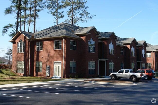
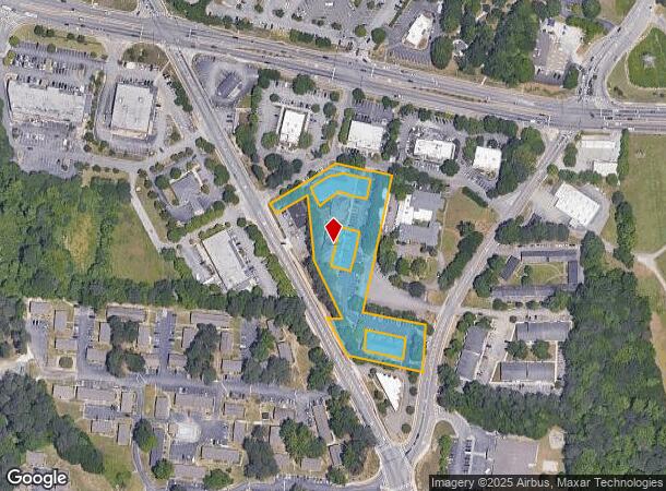
920 Dannon Vw Sw
14F-0010-LL-119-2
Cascade Prof Park Busn Condo
Commercialcondominium
Fulton
X
Georgia
13121C0332F
0.03 AC
2024
Douglasville/Lithia Springs
2025
Atlanta
007703
Atlanta-Sandy Springs-Roswell, GA
1,198 SF
DEMOGRAPHICS near 920 Dannon Vw Sw
1 Mile
3 Mile
5 Mile
2024 Total Population
5,385
57,048
159,536
2029 Population
5,542
59,095
165,750
Pop Growth 2024-2029
+ 2.92%
+ 3.59%
+ 3.90%
Average Age
40
40
39
2024 Total Households
2,297
23,357
65,567
HH Growth 2024-2029
+ 3.05%
+ 3.69%
+ 3.94%
Median Household Inc
$56,347
$52,901
$49,753
Avg Household Size
2.30
2.40
2.40
2024 Avg HH Vehicles
2.00
1.00
1.00
Median Home Value
$250,099
$256,055
$247,358
Median Year Built
1989
1975
1971
Nearby Places
Map Layers
Map Styles
 Street
 Aerial
- Restaurants
- Banks
- Shops
- Fitness
- Groceries
PUBLIC TRANSPORTATION
AIRPORT
Hartsfield - Jackson Atlanta International
DRIVE
WALK
Distance
Hartsfield - Jackson Atlanta International
22 min
14.4 mi
SALE & LEASE HISTORY
LISTING DATE
SALE/LEASE

Sep 25, 2016
For Lease
Sep 15, 2024
For Sale
Oct 04, 2022
For Sale
Nov 12, 2021
For Sale
Feb 27, 2023
For Sale
Dec 20, 2021
For Sale
Aug 05, 2017
For Sale
Nearby Properties
Address
Land Use
TOTAL SIZE
Lot Size
Zoning
Address
Land Use
TOTAL SIZE
Lot Size
Zoning
802,908 SF
18.26 AC
RG3
Address
Land Use
TOTAL SIZE
Lot Size
Zoning
5,459 SF
12.97 AC
C1
Address
Land Use
TOTAL SIZE
Lot Size
Zoning
282,610 SF
11.20 AC
C1
Address
Land Use
TOTAL SIZE
Lot Size
Zoning
6,603,740 SF
24.69 AC
RG3
Address
Land Use
TOTAL SIZE
Lot Size
Zoning
814,536 SF
37 AC
R3
Address
Land Use
TOTAL SIZE
Lot Size
Zoning
274,442 SF
20.33 AC
RG2
Address
Land Use
TOTAL SIZE
Lot Size
Zoning
3,268,352 SF
23.31 AC
RG2
Address
Land Use
TOTAL SIZE
Lot Size
Zoning
135,211 SF
51.76 AC
OI
Address
Land Use
TOTAL SIZE
Lot Size
Zoning
1,825,146 SF
16.16 AC
RG3
Address
Land Use
TOTAL SIZE
Lot Size
Zoning
3,289,702 SF
16.23 AC
C1C
Address
Land Use
TOTAL SIZE
Lot Size
Zoning
395,218 SF
21.61 AC
A1
Address
Land Use
TOTAL SIZE
Lot Size
Zoning
70.35 AC
R3
Address
Land Use
TOTAL SIZE
Lot Size
Zoning
6,834,480 SF
9.85 AC
RG3
Address
Land Use
TOTAL SIZE
Lot Size
Zoning
2,002,026 SF
17.51 AC
RLC
Address
Land Use
TOTAL SIZE
Lot Size
Zoning
77.30 AC
M2
Address
Land Use
TOTAL SIZE
Lot Size
Zoning
9,590,784 SF
27.23 AC
RG3
Address
Land Use
TOTAL SIZE
Lot Size
Zoning
764,659 SF
51.57 AC
C1
Address
Land Use
TOTAL SIZE
Lot Size
Zoning
1,715,322 SF
18.09 AC
A1
Address
Land Use
TOTAL SIZE
Lot Size
Zoning
1,477,770 SF
13.60 AC
C1
Address
Land Use
TOTAL SIZE
Lot Size
Zoning
680,087 SF
41.40 AC
M2
Address
Land Use
TOTAL SIZE
Lot Size
Zoning
725,612 SF
11.60 AC
A
Address
Land Use
TOTAL SIZE
Lot Size
Zoning
7,668 SF
17.29 AC
C1
Address
Land Use
TOTAL SIZE
Lot Size
Zoning
130,000 SF
4.28 AC
R4
Address
Land Use
TOTAL SIZE
Lot Size
Zoning
191,540 SF
7.74 AC
RG3
Address
Land Use
TOTAL SIZE
Lot Size
Zoning
1,454,400 SF
14.81 AC
RG3
Address
Land Use
TOTAL SIZE
Lot Size
Zoning
442,740 SF
5.46 AC
RG3
Address
Land Use
TOTAL SIZE
Lot Size
Zoning
156,148 SF
27.07 AC
C1
Address
Land Use
TOTAL SIZE
Lot Size
Zoning
122.60 AC
R3
Address
Land Use
TOTAL SIZE
Lot Size
Zoning
168,245 SF
20.71 AC
C1C
Address
Land Use
TOTAL SIZE
Lot Size
Zoning
206,708 SF
5.75 AC
C1C
The World's #1 Commercial Real Estate Marketplace
Connect with us
© 2025 CoStar Group
The information above has been obtained from sources believed reliable. While we do not doubt its accuracy we have not verified it and make no guarantee, warranty or representation about it. It is your responsibility to independently confirm its accuracy and completeness. Any projections, opinions, assumptions, or estimates used are for example only and do not represent the current or future performance of the property. The value of this transaction to you depends on tax and other factors which should be evaluated by your tax, financial, and legal advisors. You and your advisors should conduct a careful, independent investigation of the property to determine to your satisfaction the suitability of the property for your needs.