Property Record
920 Holley Ave, Saint Paul Park, MN 55071


Current Lease Availabilities
NEARBY LISTINGS FOR SALE OR LEASE
-
-
View all Saint Paul Park listings for lease on LoopNet.com
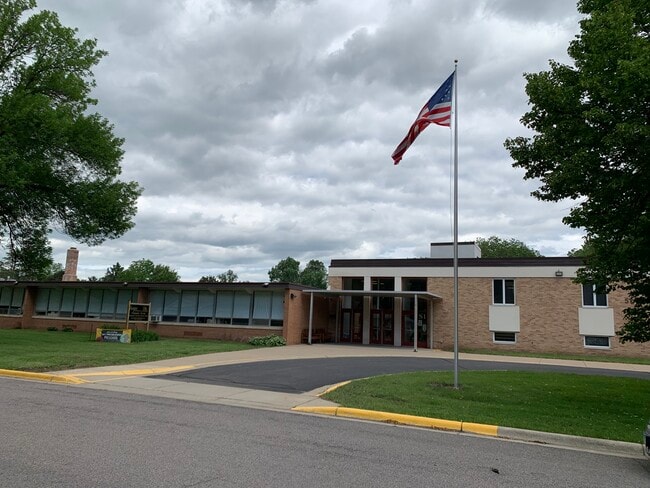
Property Detail
920 Holley Ave
Minneapolis-St. Paul-Bloomington, MN-WI
Div No.3 St Paul Park
12-027-22-14-0091
BLOCK 217 LOT 18 SUBDIVISIONCD 68444 SUBDIVISIONNAME DIV NO.3 ST PAUL PARK BLK A,B,213-219,232-263 BLOCK 217 LOT 19 SUBDIVISI
Religious
Washington
X
Minnesota
27037C0150E
18
2025
9.36 AC
2024
Washington Cnty Outlying
071300
Minneapolis/St Paul
15,696 SF
DEMOGRAPHICS near 920 Holley Ave
1 Mile
3 Mile
5 Mile
2024 Total Population
6,706
51,857
120,931
2029 Population
7,201
55,474
128,458
Pop Growth 2024-2029
+ 7.38%
+ 6.97%
+ 6.22%
Average Age
39
39
39
2024 Total Households
2,503
18,964
45,072
HH Growth 2024-2029
+ 7.47%
+ 6.83%
+ 5.98%
Median Household Inc
$82,780
$91,591
$94,869
Avg Household Size
2.60
2.70
2.60
2024 Avg HH Vehicles
2.00
2.00
2.00
Median Home Value
$251,310
$289,555
$319,803
Median Year Built
1972
1982
1987
Nearby Places
Map Layers
Map Styles
 Street
 Aerial
- Restaurants
- Banks
- Shops
- Fitness
- Groceries
PUBLIC TRANSPORTATION
AIRPORT
Minneapolis-St Paul International/Wold-Chamberlain
DRIVE
WALK
Distance
Minneapolis-St Paul International/Wold-Chamberlain
26 min
16.2 mi
Freight Ports
Port Milwaukee
DRIVE
WALK
Distance
Port Milwaukee
365 min
330.6 mi
Nearby Properties
Address
Land Use
TOTAL SIZE
Lot Size
Zoning
Address
Land Use
TOTAL SIZE
Lot Size
Zoning
82,664 SF
38.21 AC
Address
Land Use
TOTAL SIZE
Lot Size
Zoning
238,188 SF
4.86 AC
Address
Land Use
TOTAL SIZE
Lot Size
Zoning
196,078 SF
31.29 AC
Address
Land Use
TOTAL SIZE
Lot Size
Zoning
605,774 SF
44.50 AC
Address
Land Use
TOTAL SIZE
Lot Size
Zoning
794,084 SF
6.97 AC
Address
Land Use
TOTAL SIZE
Lot Size
Zoning
123,968 SF
3.19 AC
Address
Land Use
TOTAL SIZE
Lot Size
Zoning
71,164 SF
10.79 AC
Address
Land Use
TOTAL SIZE
Lot Size
Zoning
169,237 SF
23.38 AC
Address
Land Use
TOTAL SIZE
Lot Size
Zoning
186,856 SF
Address
Land Use
TOTAL SIZE
Lot Size
Zoning
218,012 SF
9.22 AC
Address
Land Use
TOTAL SIZE
Lot Size
Zoning
192,004 SF
7.75 AC
Address
Land Use
TOTAL SIZE
Lot Size
Zoning
188,997 SF
12.57 AC
Address
Land Use
TOTAL SIZE
Lot Size
Zoning
94,822 SF
34.92 AC
Address
Land Use
TOTAL SIZE
Lot Size
Zoning
150,469 SF
10.73 AC
Address
Land Use
TOTAL SIZE
Lot Size
Zoning
97,340 SF
9.80 AC
Address
Land Use
TOTAL SIZE
Lot Size
Zoning
144,000 SF
Address
Land Use
TOTAL SIZE
Lot Size
Zoning
72,185 SF
36.93 AC
Address
Land Use
TOTAL SIZE
Lot Size
Zoning
168,235 SF
20.12 AC
Address
Land Use
TOTAL SIZE
Lot Size
Zoning
117,356 SF
2.96 AC
Address
Land Use
TOTAL SIZE
Lot Size
Zoning
219,438 SF
90.20 AC
Address
Land Use
TOTAL SIZE
Lot Size
Zoning
154,800 SF
15.33 AC
Address
Land Use
TOTAL SIZE
Lot Size
Zoning
95,872 SF
9.61 AC
Address
Land Use
TOTAL SIZE
Lot Size
Zoning
103,800 SF
4.94 AC
Address
Land Use
TOTAL SIZE
Lot Size
Zoning
143,712 SF
9.57 AC
Address
Land Use
TOTAL SIZE
Lot Size
Zoning
69,483 SF
11.27 AC
Address
Land Use
TOTAL SIZE
Lot Size
Zoning
121,200 SF
25.30 AC
Address
Land Use
TOTAL SIZE
Lot Size
Zoning
161,676 SF
13.90 AC
Address
Land Use
TOTAL SIZE
Lot Size
Zoning
64,860 SF
2.65 AC
Address
Land Use
TOTAL SIZE
Lot Size
Zoning
48,168 SF
6.45 AC
Address
Land Use
TOTAL SIZE
Lot Size
Zoning
135,084 SF
7.23 AC
The World's #1 Commercial Real Estate Marketplace
Connect with us
© 2026 CoStar Group
The information above has been obtained from sources believed reliable. While we do not doubt its accuracy we have not verified it and make no guarantee, warranty or representation about it. It is your responsibility to independently confirm its accuracy and completeness. Any projections, opinions, assumptions, or estimates used are for example only and do not represent the current or future performance of the property. The value of this transaction to you depends on tax and other factors which should be evaluated by your tax, financial, and legal advisors. You and your advisors should conduct a careful, independent investigation of the property to determine to your satisfaction the suitability of the property for your needs.