Property Record
920 N Bonnie Beach Pl, Los Angeles, CA 90063
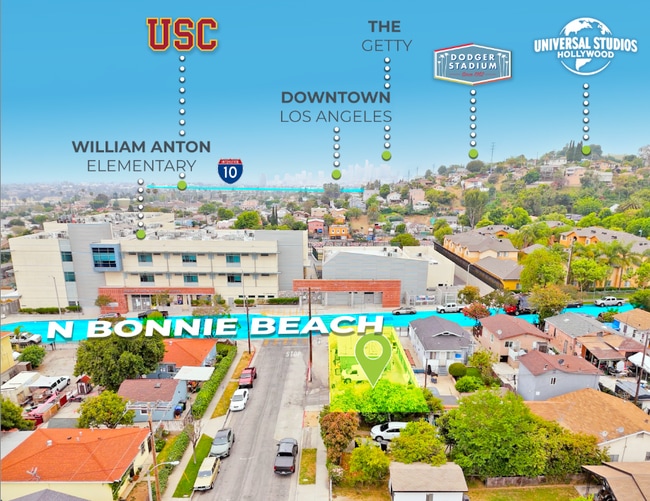


This Property Is For Sale
NEARBY LISTINGS FOR SALE OR LEASE
Property Detail
920 N Bonnie Beach Pl
Los Angeles-Long Beach-Glendale, CA
8241
5227-026-023
TRACT # 8241 S 36.28 FT MEASURED ON E LINE OF LOT 19
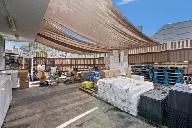
Restaurantbuilding
Los Angeles
X
California
06037C1641F
19
2024
0.08 AC
2025
Southeast Los Angeles
530902
Los Angeles
625 SF
DEMOGRAPHICS near 920 N Bonnie Beach Pl
1 Mile
3 Mile
5 Mile
2024 Total Population
39,407
274,928
744,904
2029 Population
37,713
263,102
716,905
Pop Growth 2024-2029
(4.30%)
(4.30%)
(3.76%)
Average Age
37
38
39
2024 Total Households
10,354
78,530
248,108
HH Growth 2024-2029
(4.59%)
(4.53%)
(3.62%)
Median Household Inc
$57,634
$59,492
$64,385
Avg Household Size
3.70
3.30
2.80
2024 Avg HH Vehicles
2.00
2.00
2.00
Median Home Value
$620,550
$697,986
$738,906
Median Year Built
1948
1949
1958
Nearby Places
Map Layers
Map Styles
 Street
 Aerial
- Restaurants
- Banks
- Shops
- Fitness
- Groceries
PUBLIC TRANSPORTATION
COMMUTER RAIL
DRIVE
WALK
Distance
8 min
4.4 mi
Union Station (91 Line - Southern California Regional Rail Authority (Metrolink), Antelope Valley Line - Southern California Regional Rail Authority (Metrolink), Orange County Line - Southern California Regional Rail Authority (Metrolink), Riverside Line - Southern California Regional Rail Authority (Metrolink), San Bernardino Line - Southern California Regional Rail Authority (Metrolink), Ventura County Line - Southern California Regional Rail Authority (Metrolink))
DRIVE
WALK
Distance
Union Station (91 Line - Southern California Regional Rail Authority (Metrolink), Antelope Valley Line - Southern California Regional Rail Authority (Metrolink), Orange County Line - Southern California Regional Rail Authority (Metrolink), Riverside Line - Southern California Regional Rail Authority (Metrolink), San Bernardino Line - Southern California Regional Rail Authority (Metrolink), Ventura County Line - Southern California Regional Rail Authority (Metrolink))
10 min
4.6 mi
AIRPORT
Long Beach (Daugherty Field)
DRIVE
WALK
Distance
Long Beach (Daugherty Field)
29 min
18.8 mi
Bob Hope
DRIVE
WALK
Distance
Bob Hope
27 min
19.0 mi
Los Angeles International
DRIVE
WALK
Distance
Los Angeles International
33 min
20.4 mi
Freight Ports
Port of Long Beach
DRIVE
WALK
Distance
Port of Long Beach
30 min
21.7 mi
Nearby Properties
Address
Land Use
TOTAL SIZE
Lot Size
Zoning
Address
Land Use
TOTAL SIZE
Lot Size
Zoning
635,233 SF
12.02 AC
LAR5
Address
Land Use
TOTAL SIZE
Lot Size
Zoning
513,825 SF
4.28 AC
LAC2
Address
Land Use
TOTAL SIZE
Lot Size
Zoning
444,139 SF
3.63 AC
LAM3
Address
Land Use
TOTAL SIZE
Lot Size
Zoning
534,225 SF
Address
Land Use
TOTAL SIZE
Lot Size
Zoning
479,272 SF
16.14 AC
LAM3
Address
Land Use
TOTAL SIZE
Lot Size
Zoning
460,590 SF
23.95 AC
ALMPD*
Address
Land Use
TOTAL SIZE
Lot Size
Zoning
327,061 SF
2.18 AC
LAM3
Address
Land Use
TOTAL SIZE
Lot Size
Zoning
328,737 SF
7.92 AC
LAC2
Address
Land Use
TOTAL SIZE
Lot Size
Zoning
354,299 SF
2.18 AC
LAC2
Address
Land Use
TOTAL SIZE
Lot Size
Zoning
150,608 SF
0.88 AC
LAC2
Address
Land Use
TOTAL SIZE
Lot Size
Zoning
527,173 SF
12.36 AC
CMM2*
Address
Land Use
TOTAL SIZE
Lot Size
Zoning
252,559 SF
2.87 AC
LAC2
Address
Land Use
TOTAL SIZE
Lot Size
Zoning
172,072 SF
1.82 AC
LAC2
Address
Land Use
TOTAL SIZE
Lot Size
Zoning
75,589 SF
0.98 AC
LAC2
Address
Land Use
TOTAL SIZE
Lot Size
Zoning
303,030 SF
7.14 AC
CMM2-M1*
Address
Land Use
TOTAL SIZE
Lot Size
Zoning
198,958 SF
7.50 AC
LCM2*
Address
Land Use
TOTAL SIZE
Lot Size
Zoning
1,086,660 SF
26.15 AC
LAM3
Address
Land Use
TOTAL SIZE
Lot Size
Zoning
500,495 SF
16.23 AC
CMM2*
Address
Land Use
TOTAL SIZE
Lot Size
Zoning
116,109 SF
0.92 AC
LACM
Address
Land Use
TOTAL SIZE
Lot Size
Zoning
112,242 SF
1.64 AC
LAM3
Address
Land Use
TOTAL SIZE
Lot Size
Zoning
342,940 SF
6.21 AC
LAM2
Address
Land Use
TOTAL SIZE
Lot Size
Zoning
39,602 SF
2.22 AC
LAM3
Address
Land Use
TOTAL SIZE
Lot Size
Zoning
149,846 SF
5.85 AC
VEM*
Address
Land Use
TOTAL SIZE
Lot Size
Zoning
99,563 SF
1.29 AC
LAM3
Address
Land Use
TOTAL SIZE
Lot Size
Zoning
78,354 SF
0.55 AC
LAM3
Address
Land Use
TOTAL SIZE
Lot Size
Zoning
116,480 SF
11.81 AC
MPC2
Address
Land Use
TOTAL SIZE
Lot Size
Zoning
199,809 SF
7.57 AC
CMM2*
Address
Land Use
TOTAL SIZE
Lot Size
Zoning
122,596 SF
4.55 AC
LAM2
Address
Land Use
TOTAL SIZE
Lot Size
Zoning
155,529 SF
2.64 AC
LARD1.5
Address
Land Use
TOTAL SIZE
Lot Size
Zoning
109,400 SF
11.24 AC
LAM3
The World's #1 Commercial Real Estate Marketplace
Connect with us
© 2026 CoStar Group
The information above has been obtained from sources believed reliable. While we do not doubt its accuracy we have not verified it and make no guarantee, warranty or representation about it. It is your responsibility to independently confirm its accuracy and completeness. Any projections, opinions, assumptions, or estimates used are for example only and do not represent the current or future performance of the property. The value of this transaction to you depends on tax and other factors which should be evaluated by your tax, financial, and legal advisors. You and your advisors should conduct a careful, independent investigation of the property to determine to your satisfaction the suitability of the property for your needs.