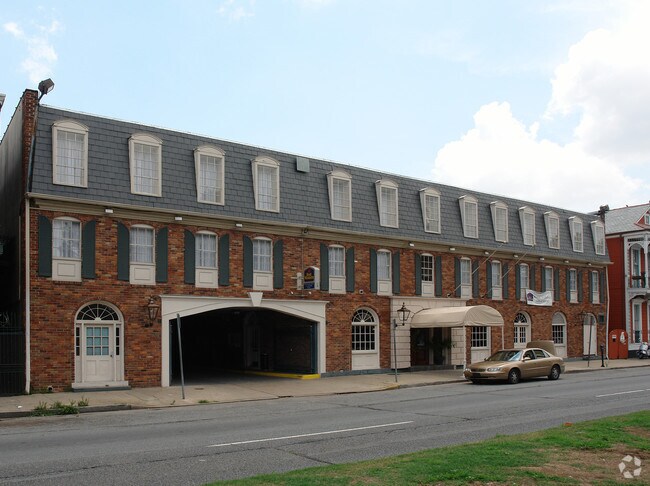
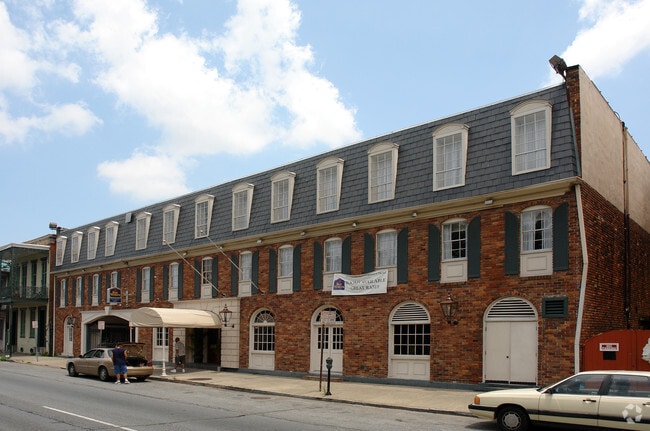
Property Record
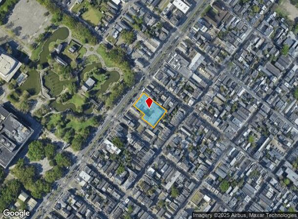
920 N Rampart St, New Orleans, LA 70116
NEARBY LISTINGS FOR SALE OR LEASE
Property Detail
920 N Rampart St
2-07-1-040-23
SQ 104 LOT 15 N RAMPART 142 OVER 112X211
Hotel
Orleans
X
Louisiana
22051C0225F
15
2025
0.63 AC
2025
New Orleans CBD/French Quarter
013501
New Orleans/Metairie/Kenner
41,146 SF
New Orleans-Metairie, LA
DEMOGRAPHICS near 920 N Rampart St
1 Mile
3 Mile
5 Mile
2024 Total Population
24,147
163,056
351,155
2029 Population
24,055
158,492
339,210
Pop Growth 2024-2029
(0.38%)
(2.80%)
(3.40%)
Average Age
44
41
41
2024 Total Households
14,354
79,159
155,706
HH Growth 2024-2029
(0.10%)
(2.72%)
(3.43%)
Median Household Inc
$40,953
$43,332
$50,389
Avg Household Size
1.60
2.00
2.10
2024 Avg HH Vehicles
1.00
1.00
1.00
Median Home Value
$405,618
$313,062
$308,163
Median Year Built
1946
1948
1954
Nearby Places
Map Layers
Map Styles
 Street
 Aerial
- Restaurants
- Banks
- Shops
- Fitness
- Groceries
PUBLIC TRANSPORTATION
TRANSIT/SUBWAY
N. Rampart St. At St. Ann St. (Rampart-Loyola Streetcar - NORTA)
DRIVE
WALK
Distance
N. Rampart St. At St. Ann St. (Rampart-Loyola Streetcar - NORTA)
1 min
2 min
0.1 mi
N. Rampart St. At Ursulines Ave. (Rampart-Loyola Streetcar - NORTA)
DRIVE
WALK
Distance
N. Rampart St. At Ursulines Ave. (Rampart-Loyola Streetcar - NORTA)
0 min
2 min
0.1 mi
N. Rampart St. At Esplanade Ave. (Rampart-Loyola Streetcar - NORTA)
DRIVE
WALK
Distance
N. Rampart St. At Esplanade Ave. (Rampart-Loyola Streetcar - NORTA)
0 min
6 min
0.3 mi
N. Rampart St. At Conti St. (Rampart-Loyola Streetcar - NORTA)
DRIVE
WALK
Distance
N. Rampart St. At Conti St. (Rampart-Loyola Streetcar - NORTA)
1 min
7 min
0.4 mi
Dumaine Street Station (Canal-Cemeteries Streetcar - NORTA, Canal-Museum Streetcar - NORTA, Riverfront Streetcar - NORTA, UPT-Riverfront - NORTA)
DRIVE
WALK
Distance
Dumaine Street Station (Canal-Cemeteries Streetcar - NORTA, Canal-Museum Streetcar - NORTA, Riverfront Streetcar - NORTA, UPT-Riverfront - NORTA)
4 min
9 min
0.5 mi
COMMUTER RAIL
New Orleans Union Passenger Terminal (City of New Orleans - Amtrak, Crescent - Amtrak, Sunset Limited - Amtrak)
DRIVE
WALK
Distance
New Orleans Union Passenger Terminal (City of New Orleans - Amtrak, Crescent - Amtrak, Sunset Limited - Amtrak)
4 min
1.7 mi
AIRPORT
Louis Armstrong New Orleans International
DRIVE
WALK
Distance
Louis Armstrong New Orleans International
23 min
16.0 mi
Freight Ports
Port of New Orleans
DRIVE
WALK
Distance
Port of New Orleans
13 min
4.1 mi
Nearby Properties
Address
Land Use
TOTAL SIZE
Lot Size
Zoning
Address
Land Use
TOTAL SIZE
Lot Size
Zoning
Address
Land Use
TOTAL SIZE
Lot Size
Zoning
300 SF
2.19 AC
LS
Address
Land Use
TOTAL SIZE
Lot Size
Zoning
85,052 SF
2.19 AC
LS
Address
Land Use
TOTAL SIZE
Lot Size
Zoning
44.43 AC
CBD-4
Address
Land Use
TOTAL SIZE
Lot Size
Zoning
66.23 AC
CBD-4
Address
Land Use
TOTAL SIZE
Lot Size
Zoning
3.66 AC
MC
Address
Land Use
TOTAL SIZE
Lot Size
Zoning
834,043 SF
1.40 AC
CBD-2
Address
Land Use
TOTAL SIZE
Lot Size
Zoning
18.31 AC
CBD-4
Address
Land Use
TOTAL SIZE
Lot Size
Zoning
1.87 AC
CBD-2
Address
Land Use
TOTAL SIZE
Lot Size
Zoning
6.64 AC
Address
Land Use
TOTAL SIZE
Lot Size
Zoning
844,362 SF
5.85 AC
CBD-4
Address
Land Use
TOTAL SIZE
Lot Size
Zoning
0.12 AC
Address
Land Use
TOTAL SIZE
Lot Size
Zoning
30.63 AC
Address
Land Use
TOTAL SIZE
Lot Size
Zoning
444,121 SF
1.46 AC
CBD-1
Address
Land Use
TOTAL SIZE
Lot Size
Zoning
0.88 AC
CBD-2
Address
Land Use
TOTAL SIZE
Lot Size
Zoning
22.17 AC
Address
Land Use
TOTAL SIZE
Lot Size
Zoning
725,677 SF
54.19 AC
EC
Address
Land Use
TOTAL SIZE
Lot Size
Zoning
1.91 AC
CBD-1
Address
Land Use
TOTAL SIZE
Lot Size
Zoning
576,962 SF
3.31 AC
CBD-4
Address
Land Use
TOTAL SIZE
Lot Size
Zoning
1.79 AC
Address
Land Use
TOTAL SIZE
Lot Size
Zoning
512,729 SF
6.60 AC
Address
Land Use
TOTAL SIZE
Lot Size
Zoning
1.24 AC
CBD-1
Address
Land Use
TOTAL SIZE
Lot Size
Zoning
190,708 SF
1.09 AC
CBD-2
Address
Land Use
TOTAL SIZE
Lot Size
Zoning
225,284 SF
16.83 AC
S-RD
Address
Land Use
TOTAL SIZE
Lot Size
Zoning
499,287 SF
1.44 AC
VCE
Address
Land Use
TOTAL SIZE
Lot Size
Zoning
0.67 AC
CBD-3
Address
Land Use
TOTAL SIZE
Lot Size
Zoning
202,291 SF
4.04 AC
HU-RD2
Address
Land Use
TOTAL SIZE
Lot Size
Zoning
162,382 SF
1.25 AC
CBD-2
Address
Land Use
TOTAL SIZE
Lot Size
Zoning
258,024 SF
0.63 AC
CBD-2
Address
Land Use
TOTAL SIZE
Lot Size
Zoning
2.94 AC
CBD-1
The World's #1 Commercial Real Estate Marketplace
Connect with us
© 2025 CoStar Group
The information above has been obtained from sources believed reliable. While we do not doubt its accuracy we have not verified it and make no guarantee, warranty or representation about it. It is your responsibility to independently confirm its accuracy and completeness. Any projections, opinions, assumptions, or estimates used are for example only and do not represent the current or future performance of the property. The value of this transaction to you depends on tax and other factors which should be evaluated by your tax, financial, and legal advisors. You and your advisors should conduct a careful, independent investigation of the property to determine to your satisfaction the suitability of the property for your needs.