Property Record
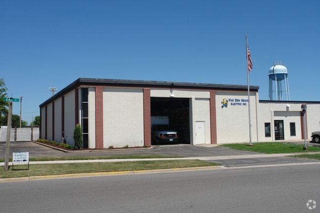
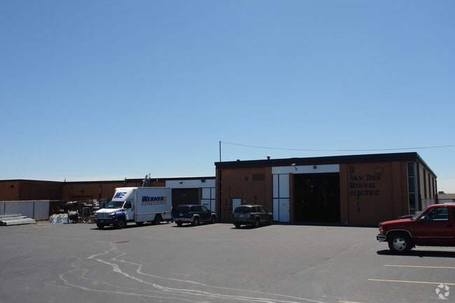
920 Oak St, De Pere, WI 54115

Property Detail
920 Oak St
WD-1845
OAK STREET CONDOMINIUM UNIT 1 TOGETHER WITH UNDIVIDED INTEREST IN COMMON ELEMENTS ETC IN 2381806
Warehouse
Brown
B and X Area of moderate flood hazard, usually the area between the limits of the 100-year and 500-year floods.
Wisconsin
2025
2.69 AC
2025
Ashwaubenon
010201
Green Bay
4,560 SF
Green Bay, WI
NEARBY LISTINGS FOR SALE OR LEASE
DEMOGRAPHICS near 920 Oak St
1 mile
3 mile
5 mile
2025 Total Population
5,353
45,424
103,732
2030 Population
5,438
46,204
105,682
Pop Growth 2025-2030
+ 1.59%
+ 1.72%
+ 1.88%
Average Age
38
41
41
2025 Total Households
2,098
19,011
43,039
HH Growth 2025-2030
+ 1.91%
+ 1.87%
+ 1.95%
Median Household Inc
$68,279
$82,528
$82,206
Avg Household Size
2.10
2.30
2.30
2025 Avg HH Vehicles
2.00
2.00
2.00
Median Home Value
$256,603
$296,839
$271,420
Median Year Built
1978
1985
1979
Nearby Places
Map Layers
Map Styles
 Street
 Aerial
Layers
 Traffic
 Biking
Places
Listings with unknown addresses are not visible on the map
- Restaurants
- Banks
- Shops
- Fitness
- Groceries
PUBLIC TRANSPORTATION
AIRPORT
Green Bay/Austin Straubel International
Drive
Walk
Distance
Green Bay/Austin Straubel International
9 min
4.2 mi
Appleton International
Drive
Walk
Distance
Appleton International
39 min
31.5 mi
Freight Ports
Port Milwaukee
Drive
Walk
Distance
Port Milwaukee
138 min
119.1 mi
SALE & LEASE HISTORY
LISTING DATE
SALE/LEASE

Feb 17, 2017
For Lease
Feb 17, 2017
For Sale
Apr 09, 2018
For Lease
Nearby Properties
Address
Land Use
TOTAL SIZE
Lot Size
Zoning
Address
Land Use
TOTAL SIZE
Lot Size
Zoning
11.89 AC
Address
Land Use
TOTAL SIZE
Lot Size
Zoning
452,950 SF
34.59 AC
Address
Land Use
TOTAL SIZE
Lot Size
Zoning
175,271 SF
17.86 AC
Address
Land Use
TOTAL SIZE
Lot Size
Zoning
27.86 AC
Address
Land Use
TOTAL SIZE
Lot Size
Zoning
25.31 AC
Address
Land Use
TOTAL SIZE
Lot Size
Zoning
487,996 SF
23.04 AC
Address
Land Use
TOTAL SIZE
Lot Size
Zoning
20.53 AC
Address
Land Use
TOTAL SIZE
Lot Size
Zoning
Address
Land Use
TOTAL SIZE
Lot Size
Zoning
71.85 AC
Address
Land Use
TOTAL SIZE
Lot Size
Zoning
35.24 AC
Address
Land Use
TOTAL SIZE
Lot Size
Zoning
339,679 SF
56.88 AC
Address
Land Use
TOTAL SIZE
Lot Size
Zoning
53.92 AC
Address
Land Use
TOTAL SIZE
Lot Size
Zoning
45.50 AC
Address
Land Use
TOTAL SIZE
Lot Size
Zoning
18.61 AC
Address
Land Use
TOTAL SIZE
Lot Size
Zoning
15.61 AC
Address
Land Use
TOTAL SIZE
Lot Size
Zoning
240,000 SF
12.56 AC
Address
Land Use
TOTAL SIZE
Lot Size
Zoning
98,000 SF
10.84 AC
Address
Land Use
TOTAL SIZE
Lot Size
Zoning
26.42 AC
Address
Land Use
TOTAL SIZE
Lot Size
Zoning
9.14 AC
Address
Land Use
TOTAL SIZE
Lot Size
Zoning
37.22 AC
Address
Land Use
TOTAL SIZE
Lot Size
Zoning
Address
Land Use
TOTAL SIZE
Lot Size
Zoning
Address
Land Use
TOTAL SIZE
Lot Size
Zoning
2.98 AC
Address
Land Use
TOTAL SIZE
Lot Size
Zoning
5.94 AC
Address
Land Use
TOTAL SIZE
Lot Size
Zoning
13.58 AC
Address
Land Use
TOTAL SIZE
Lot Size
Zoning
200,000 SF
15.27 AC
Address
Land Use
TOTAL SIZE
Lot Size
Zoning
43.27 AC
Address
Land Use
TOTAL SIZE
Lot Size
Zoning
15.41 AC
Address
Land Use
TOTAL SIZE
Lot Size
Zoning
189,186 SF
17.54 AC
Address
Land Use
TOTAL SIZE
Lot Size
Zoning
6.34 AC
The World's #1 Commercial Real Estate Marketplace
Connect with us
© 2026 CoStar Group
The information above has been obtained from sources believed reliable. While we do not doubt its accuracy we have not verified it and make no guarantee, warranty or representation about it. It is your responsibility to independently confirm its accuracy and completeness. Any projections, opinions, assumptions, or estimates used are for example only and do not represent the current or future performance of the property. The value of this transaction to you depends on tax and other factors which should be evaluated by your tax, financial, and legal advisors. You and your advisors should conduct a careful, independent investigation of the property to determine to your satisfaction the suitability of the property for your needs.