Property Record
920 Skyway Ave, Chico, CA 95928

Property Detail
920 Skyway Ave
039-060-098-000
920 SKYWAY AVE
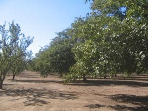
Orchard
BUTTE
A40
California
AE The base floodplain where base flood elevations are provided. AE Zones are now used on new format FIRMs instead of A1-A30 Zones.
268.44 AC
2025
Redding/Chico
2025
Other Market Areas
001200
Chico, CA
6,056 SF
NEARBY LISTINGS FOR SALE OR LEASE
DEMOGRAPHICS near 920 Skyway Ave
1 mile
3 mile
5 mile
2025 Total Population
643
28,367
83,116
2030 Population
625
27,875
81,361
Pop Growth 2025-2030
(2.80%)
(1.73%)
(2.11%)
Average Age
41
36
37
2025 Total Households
233
11,719
33,723
HH Growth 2025-2030
(2.58%)
(1.78%)
(2.30%)
Median Household Inc
$127,381
$58,715
$66,251
Avg Household Size
2.60
2.30
2.30
2025 Avg HH Vehicles
2.00
2.00
2.00
Median Home Value
$626,865
$455,172
$475,199
Median Year Built
1975
1976
1980
Nearby Places
Map Layers
Map Styles
 Street
 Aerial
Layers
 Traffic
 Biking
Places
Listings with unknown addresses are not visible on the map
- Restaurants
- Banks
- Shops
- Fitness
- Groceries
PUBLIC TRANSPORTATION
COMMUTER RAIL
Chico Amtrak (Coast Starlight - Amtrak)
Drive
Walk
Distance
Chico Amtrak (Coast Starlight - Amtrak)
9 min
3.9 mi
Freight Ports
Port of Stockton
Drive
Walk
Distance
Port of Stockton
161 min
131.5 mi
Nearby Properties
Address
Land Use
TOTAL SIZE
Lot Size
Zoning
Address
Land Use
TOTAL SIZE
Lot Size
Zoning
102,010 SF
12.55 AC
Address
Land Use
TOTAL SIZE
Lot Size
Zoning
58,013 SF
7.08 AC
TND
Address
Land Use
TOTAL SIZE
Lot Size
Zoning
32,880 SF
25.36 AC
Address
Land Use
TOTAL SIZE
Lot Size
Zoning
20,643 SF
3.32 AC
TND
Address
Land Use
TOTAL SIZE
Lot Size
Zoning
84,280 SF
1.60 AC
R4
Address
Land Use
TOTAL SIZE
Lot Size
Zoning
133,120 SF
5.37 AC
R3
Address
Land Use
TOTAL SIZE
Lot Size
Zoning
141,333 SF
7.08 AC
Address
Land Use
TOTAL SIZE
Lot Size
Zoning
56,480 SF
10.28 AC
PQ
Address
Land Use
TOTAL SIZE
Lot Size
Zoning
158,426 SF
16.19 AC
M1
Address
Land Use
TOTAL SIZE
Lot Size
Zoning
160,214 SF
13.50 AC
Address
Land Use
TOTAL SIZE
Lot Size
Zoning
175,392 SF
14.83 AC
Address
Land Use
TOTAL SIZE
Lot Size
Zoning
31,291 SF
6.10 AC
CR
Address
Land Use
TOTAL SIZE
Lot Size
Zoning
18,809 SF
13.55 AC
Address
Land Use
TOTAL SIZE
Lot Size
Zoning
3.30 AC
CR
Address
Land Use
TOTAL SIZE
Lot Size
Zoning
51,698 SF
3.88 AC
C2
Address
Land Use
TOTAL SIZE
Lot Size
Zoning
99,180 SF
10.18 AC
OC
Address
Land Use
TOTAL SIZE
Lot Size
Zoning
24.26 AC
Address
Land Use
TOTAL SIZE
Lot Size
Zoning
90,400 SF
7.50 AC
Address
Land Use
TOTAL SIZE
Lot Size
Zoning
51,805 SF
2.50 AC
CN
Address
Land Use
TOTAL SIZE
Lot Size
Zoning
105,700 SF
10.03 AC
Address
Land Use
TOTAL SIZE
Lot Size
Zoning
105,390 SF
8.13 AC
Address
Land Use
TOTAL SIZE
Lot Size
Zoning
125,873 SF
11.32 AC
Address
Land Use
TOTAL SIZE
Lot Size
Zoning
16.94 AC
Address
Land Use
TOTAL SIZE
Lot Size
Zoning
106,064 SF
8.66 AC
Address
Land Use
TOTAL SIZE
Lot Size
Zoning
64,600 SF
2.15 AC
TND
Address
Land Use
TOTAL SIZE
Lot Size
Zoning
1,861 SF
27.94 AC
Address
Land Use
TOTAL SIZE
Lot Size
Zoning
172,962 SF
10.23 AC
R3
Address
Land Use
TOTAL SIZE
Lot Size
Zoning
253,279 SF
6.49 AC
Address
Land Use
TOTAL SIZE
Lot Size
Zoning
75,625 SF
6.63 AC
Address
Land Use
TOTAL SIZE
Lot Size
Zoning
55,463 SF
1.38 AC
CC
The World's #1 Commercial Real Estate Marketplace
Connect with us
© 2026 CoStar Group
The information above has been obtained from sources believed reliable. While we do not doubt its accuracy we have not verified it and make no guarantee, warranty or representation about it. It is your responsibility to independently confirm its accuracy and completeness. Any projections, opinions, assumptions, or estimates used are for example only and do not represent the current or future performance of the property. The value of this transaction to you depends on tax and other factors which should be evaluated by your tax, financial, and legal advisors. You and your advisors should conduct a careful, independent investigation of the property to determine to your satisfaction the suitability of the property for your needs.