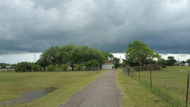
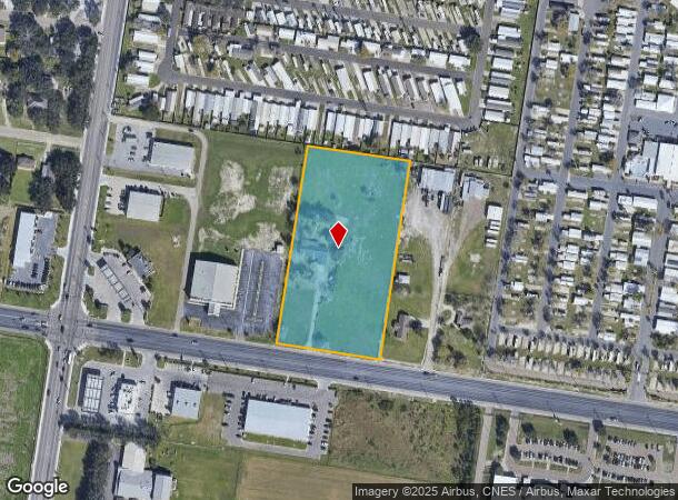
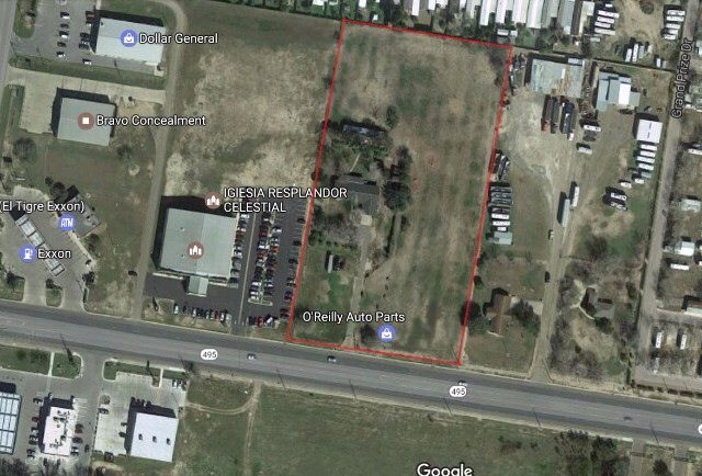
Property Record
920 State Highway 495, Alamo, TX 78516
NEARBY LISTINGS FOR SALE OR LEASE
Property Detail
920 State Highway 495
McAllen/Edinburg/Pharr
Alamo Land & Sugar Co
McAllen-Edinburg-Mission, TX
ALAMO LAND & SUGAR CO W330-E660-S660-LOT 5 BLK 40 EXC NW 0.87AC-S330 FOR H/S 4.50AC GR 3.90AC NET
A1800-00-040-0005-02
Hidalgo
Privatepreserveopenspacevacantlandforestlandconservation
Texas
2024
5
2025
3.90 AC
021905
Outlying Hidalgo County
DEMOGRAPHICS near 920 State Highway 495
1 Mile
3 Mile
5 Mile
2024 Total Population
8,079
71,177
180,938
2029 Population
8,757
75,416
192,226
Pop Growth 2024-2029
+ 8.39%
+ 5.96%
+ 6.24%
Average Age
42
35
34
2024 Total Households
2,768
20,460
52,381
HH Growth 2024-2029
+ 9.25%
+ 6.19%
+ 6.51%
Median Household Inc
$38,015
$40,858
$41,502
Avg Household Size
2.90
3.40
3.30
2024 Avg HH Vehicles
2.00
2.00
2.00
Median Home Value
$100,259
$88,603
$87,648
Median Year Built
1997
1997
1999
Nearby Places
Map Layers
Map Styles
 Street
 Aerial
- Restaurants
- Banks
- Shops
- Fitness
- Groceries
PUBLIC TRANSPORTATION
AIRPORT
McAllen International
DRIVE
WALK
Distance
McAllen International
14 min
9.7 mi
Valley International
DRIVE
WALK
Distance
Valley International
42 min
33.7 mi
Freight Ports
Port of Brownsville
DRIVE
WALK
Distance
Port of Brownsville
60 min
53.0 mi
SALE & LEASE HISTORY
LISTING DATE
SALE/LEASE

Oct 06, 2023
For Sale
May 18, 2017
For Sale
Nearby Properties
Address
Land Use
TOTAL SIZE
Lot Size
Zoning
Address
Land Use
TOTAL SIZE
Lot Size
Zoning
175,594 SF
24.77 AC
Address
Land Use
TOTAL SIZE
Lot Size
Zoning
112,792 SF
29 AC
Address
Land Use
TOTAL SIZE
Lot Size
Zoning
1 SF
19.70 AC
Address
Land Use
TOTAL SIZE
Lot Size
Zoning
226,190 SF
18.38 AC
CO
Address
Land Use
TOTAL SIZE
Lot Size
Zoning
170,694 SF
27.21 AC
Address
Land Use
TOTAL SIZE
Lot Size
Zoning
3 SF
37.26 AC
Address
Land Use
TOTAL SIZE
Lot Size
Zoning
2 SF
22.11 AC
Address
Land Use
TOTAL SIZE
Lot Size
Zoning
199,072 SF
39.71 AC
Address
Land Use
TOTAL SIZE
Lot Size
Zoning
1 SF
7.14 AC
Address
Land Use
TOTAL SIZE
Lot Size
Zoning
93,591 SF
18.75 AC
Address
Land Use
TOTAL SIZE
Lot Size
Zoning
64,074 SF
25.57 AC
Address
Land Use
TOTAL SIZE
Lot Size
Zoning
2 SF
21.76 AC
CO
Address
Land Use
TOTAL SIZE
Lot Size
Zoning
89,319 SF
29 AC
Address
Land Use
TOTAL SIZE
Lot Size
Zoning
38.61 AC
Address
Land Use
TOTAL SIZE
Lot Size
Zoning
1 SF
30 AC
CO
Address
Land Use
TOTAL SIZE
Lot Size
Zoning
111,512 SF
9.86 AC
CO
Address
Land Use
TOTAL SIZE
Lot Size
Zoning
Address
Land Use
TOTAL SIZE
Lot Size
Zoning
154,704 SF
25.81 AC
Address
Land Use
TOTAL SIZE
Lot Size
Zoning
3 SF
20.55 AC
Address
Land Use
TOTAL SIZE
Lot Size
Zoning
74,640 SF
13.42 AC
Address
Land Use
TOTAL SIZE
Lot Size
Zoning
40,000 SF
2.70 AC
Address
Land Use
TOTAL SIZE
Lot Size
Zoning
1 SF
9.78 AC
Address
Land Use
TOTAL SIZE
Lot Size
Zoning
19,071 SF
9.40 AC
Address
Land Use
TOTAL SIZE
Lot Size
Zoning
66,840 SF
3.43 AC
Address
Land Use
TOTAL SIZE
Lot Size
Zoning
32,594 SF
13.80 AC
Address
Land Use
TOTAL SIZE
Lot Size
Zoning
83,847 SF
9.97 AC
Address
Land Use
TOTAL SIZE
Lot Size
Zoning
46,796 SF
24 AC
Address
Land Use
TOTAL SIZE
Lot Size
Zoning
75,500 SF
18.76 AC
Address
Land Use
TOTAL SIZE
Lot Size
Zoning
69,590 SF
6.48 AC
CO
Address
Land Use
TOTAL SIZE
Lot Size
Zoning
25,146 SF
29.09 AC
RMH
The World's #1 Commercial Real Estate Marketplace
Connect with us
© 2025 CoStar Group
The information above has been obtained from sources believed reliable. While we do not doubt its accuracy we have not verified it and make no guarantee, warranty or representation about it. It is your responsibility to independently confirm its accuracy and completeness. Any projections, opinions, assumptions, or estimates used are for example only and do not represent the current or future performance of the property. The value of this transaction to you depends on tax and other factors which should be evaluated by your tax, financial, and legal advisors. You and your advisors should conduct a careful, independent investigation of the property to determine to your satisfaction the suitability of the property for your needs.