No Photo
Property Record
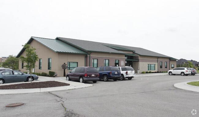
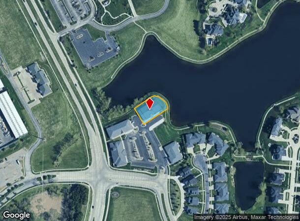
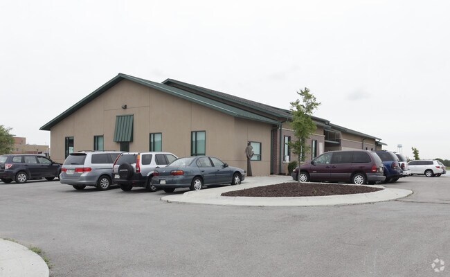
9200 Andermatt Dr, Lincoln, NE 68526
NEARBY LISTINGS FOR SALE OR LEASE
Property Detail
9200 Andermatt Dr
Lincoln, NE
South Lake Addition
16-23-402-003-000
SOUTH LAKE ADDITION, LOT 3
Officebuilding
Lancaster
X
Nebraska
31109C0452F
3
2024
0.44 AC
2025
Far South
003719
Lincoln
7,971 SF
DEMOGRAPHICS near 9200 Andermatt Dr
1 Mile
3 Mile
5 Mile
2024 Total Population
5,535
28,865
83,984
2029 Population
5,867
30,050
86,975
Pop Growth 2024-2029
+ 6.00%
+ 4.11%
+ 3.56%
Average Age
39
41
41
2024 Total Households
2,192
11,009
34,398
HH Growth 2024-2029
+ 6.07%
+ 4.05%
+ 3.58%
Median Household Inc
$111,006
$120,880
$88,720
Avg Household Size
2.50
2.60
2.40
2024 Avg HH Vehicles
2.00
2.00
2.00
Median Home Value
$370,558
$356,062
$290,428
Median Year Built
2010
2006
1991
Nearby Places
Map Layers
Map Styles
 Street
 Aerial
- Restaurants
- Banks
- Shops
- Fitness
- Groceries
PUBLIC TRANSPORTATION
AIRPORT
Lincoln
DRIVE
WALK
Distance
Lincoln
26 min
15.2 mi
Nearby Properties
Address
Land Use
TOTAL SIZE
Lot Size
Zoning
Address
Land Use
TOTAL SIZE
Lot Size
Zoning
121,132 SF
12.54 AC
B5
Address
Land Use
TOTAL SIZE
Lot Size
Zoning
61,818 SF
12.38 AC
B5
Address
Land Use
TOTAL SIZE
Lot Size
Zoning
185,015 SF
38.72 AC
AGR
Address
Land Use
TOTAL SIZE
Lot Size
Zoning
17,070 SF
8.95 AC
R3
Address
Land Use
TOTAL SIZE
Lot Size
Zoning
24,771 SF
11.45 AC
R5
Address
Land Use
TOTAL SIZE
Lot Size
Zoning
131,316 SF
26.31 AC
R3
Address
Land Use
TOTAL SIZE
Lot Size
Zoning
65,640 SF
7.24 AC
B5
Address
Land Use
TOTAL SIZE
Lot Size
Zoning
90,362 SF
2.53 AC
B3
Address
Land Use
TOTAL SIZE
Lot Size
Zoning
57,434 SF
15.62 AC
R4
Address
Land Use
TOTAL SIZE
Lot Size
Zoning
82,644 SF
18.57 AC
R3
Address
Land Use
TOTAL SIZE
Lot Size
Zoning
67,029 SF
17.26 AC
R3
Address
Land Use
TOTAL SIZE
Lot Size
Zoning
86,718 SF
7.16 AC
NULL
Address
Land Use
TOTAL SIZE
Lot Size
Zoning
22,650 SF
5.59 AC
R3
Address
Land Use
TOTAL SIZE
Lot Size
Zoning
71,860 SF
13.19 AC
R3
Address
Land Use
TOTAL SIZE
Lot Size
Zoning
100,452 SF
20.36 AC
AG
Address
Land Use
TOTAL SIZE
Lot Size
Zoning
76,130 SF
7.84 AC
NULL
Address
Land Use
TOTAL SIZE
Lot Size
Zoning
141,242 SF
5.73 AC
R3
Address
Land Use
TOTAL SIZE
Lot Size
Zoning
26,123 SF
5.62 AC
R3
Address
Land Use
TOTAL SIZE
Lot Size
Zoning
86,185 SF
6.06 AC
R3
Address
Land Use
TOTAL SIZE
Lot Size
Zoning
197,801 SF
22.85 AC
B5
Address
Land Use
TOTAL SIZE
Lot Size
Zoning
23,536 SF
10 AC
R3
Address
Land Use
TOTAL SIZE
Lot Size
Zoning
109,574 SF
9.53 AC
B5
Address
Land Use
TOTAL SIZE
Lot Size
Zoning
206,564 SF
18.37 AC
B5
Address
Land Use
TOTAL SIZE
Lot Size
Zoning
55,214 SF
9.41 AC
AG
Address
Land Use
TOTAL SIZE
Lot Size
Zoning
41,583 SF
6.12 AC
O3
Address
Land Use
TOTAL SIZE
Lot Size
Zoning
110,047 SF
13.60 AC
B5
Address
Land Use
TOTAL SIZE
Lot Size
Zoning
22,294 SF
10.18 AC
R3
Address
Land Use
TOTAL SIZE
Lot Size
Zoning
43,931 SF
6.12 AC
O3
Address
Land Use
TOTAL SIZE
Lot Size
Zoning
47,363 SF
2.14 AC
R3
Address
Land Use
TOTAL SIZE
Lot Size
Zoning
138,735 SF
13.09 AC
B2
The World's #1 Commercial Real Estate Marketplace
Connect with us
© 2025 CoStar Group
The information above has been obtained from sources believed reliable. While we do not doubt its accuracy we have not verified it and make no guarantee, warranty or representation about it. It is your responsibility to independently confirm its accuracy and completeness. Any projections, opinions, assumptions, or estimates used are for example only and do not represent the current or future performance of the property. The value of this transaction to you depends on tax and other factors which should be evaluated by your tax, financial, and legal advisors. You and your advisors should conduct a careful, independent investigation of the property to determine to your satisfaction the suitability of the property for your needs.