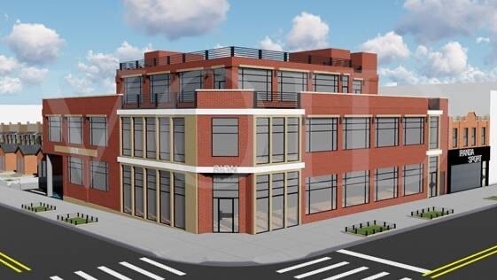
Property Record
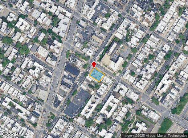
9201 5Th Ave, Brooklyn, NY 11209
NEARBY LISTINGS FOR SALE OR LEASE
Property Detail
9201 5Th Ave
06109-0023
DOCID-2023112700450001
Restaurantbuilding
Kings
X
New York
3604970332F
23
2024
0.24 AC
2025
South Brooklyn
016000
Long Island (New York)
1,430 SF
New York-Jersey City-White Plains, NY-NJ
DEMOGRAPHICS near 9201 5Th Ave
1 Mile
3 Mile
5 Mile
2024 Total Population
63,492
546,902
1,378,546
2029 Population
59,230
504,301
1,296,784
Pop Growth 2024-2029
(6.71%)
(7.79%)
(5.93%)
Average Age
43
39
40
2024 Total Households
26,525
176,955
488,004
HH Growth 2024-2029
(7.04%)
(8.10%)
(6.17%)
Median Household Inc
$84,254
$62,127
$69,434
Avg Household Size
2.30
2.90
2.70
2024 Avg HH Vehicles
1.00
1.00
1.00
Median Home Value
$903,004
$851,738
$810,581
Median Year Built
1946
1947
1948
Nearby Places
Map Layers
Map Styles
 Street
 Aerial
- Restaurants
- Banks
- Shops
- Fitness
- Groceries
PUBLIC TRANSPORTATION
TRANSIT/SUBWAY
Bay Ridge-95 Street (R - New York MTA Subway (The Subway))
DRIVE
WALK
Distance
Bay Ridge-95 Street (R - New York MTA Subway (The Subway))
0 min
2 min
0.1 mi
86 Street (R Line) (R - New York MTA Subway (The Subway))
DRIVE
WALK
Distance
86 Street (R Line) (R - New York MTA Subway (The Subway))
1 min
8 min
0.4 mi
77 Street (R Line) (R - New York MTA Subway (The Subway))
DRIVE
WALK
Distance
77 Street (R Line) (R - New York MTA Subway (The Subway))
2 min
18 min
0.9 mi
COMMUTER RAIL
Clifton (Staten Island Railway - New York MTA Subway (The Subway))
DRIVE
WALK
Distance
Clifton (Staten Island Railway - New York MTA Subway (The Subway))
9 min
4.5 mi
Stapleton (Staten Island Railway - New York MTA Subway (The Subway))
DRIVE
WALK
Distance
Stapleton (Staten Island Railway - New York MTA Subway (The Subway))
11 min
5.2 mi
AIRPORT
LaGuardia
DRIVE
WALK
Distance
LaGuardia
29 min
17.0 mi
Newark Liberty International
DRIVE
WALK
Distance
Newark Liberty International
30 min
19.1 mi
John F Kennedy International
DRIVE
WALK
Distance
John F Kennedy International
28 min
20.0 mi
Freight Ports
GCT Bayonne
DRIVE
WALK
Distance
GCT Bayonne
27 min
15.0 mi
SALE & LEASE HISTORY
LISTING DATE
SALE/LEASE

Nov 15, 2018
For Lease
May 23, 2019
For Lease
Aug 31, 2021
For Lease
Aug 11, 2020
For Lease
Nearby Properties
Address
Land Use
TOTAL SIZE
Lot Size
Zoning
Address
Land Use
TOTAL SIZE
Lot Size
Zoning
1,524,659 SF
170.96 AC
R4
Address
Land Use
TOTAL SIZE
Lot Size
Zoning
965,600 SF
6.65 AC
R5
Address
Land Use
TOTAL SIZE
Lot Size
Zoning
460,000 SF
3.21 AC
R6
Address
Land Use
TOTAL SIZE
Lot Size
Zoning
335,800 SF
1.51 AC
R6
Address
Land Use
TOTAL SIZE
Lot Size
Zoning
1,324,592 SF
5.13 AC
M3-1
Address
Land Use
TOTAL SIZE
Lot Size
Zoning
397,354 SF
0.61 AC
C5-2
Address
Land Use
TOTAL SIZE
Lot Size
Zoning
236,591 SF
207.66 AC
R3-2
Address
Land Use
TOTAL SIZE
Lot Size
Zoning
5,359,400 SF
59.07 AC
M2-1
Address
Land Use
TOTAL SIZE
Lot Size
Zoning
286,000 SF
12.63 AC
PARK
Address
Land Use
TOTAL SIZE
Lot Size
Zoning
3,970,000 SF
91.14 AC
M3-1
Address
Land Use
TOTAL SIZE
Lot Size
Zoning
689,850 SF
3.08 AC
M3-1
Address
Land Use
TOTAL SIZE
Lot Size
Zoning
301,400 SF
22.27 AC
M3-1
Address
Land Use
TOTAL SIZE
Lot Size
Zoning
673,895 SF
3.22 AC
M3-1
Address
Land Use
TOTAL SIZE
Lot Size
Zoning
139,557 SF
11.47 AC
M1-1
Address
Land Use
TOTAL SIZE
Lot Size
Zoning
171,591 SF
0.14 AC
C5-2
Address
Land Use
TOTAL SIZE
Lot Size
Zoning
581,250 SF
3.22 AC
M3-1
Address
Land Use
TOTAL SIZE
Lot Size
Zoning
183,215 SF
3.47 AC
C4-2
Address
Land Use
TOTAL SIZE
Lot Size
Zoning
292,528 SF
1.05 AC
R6
Address
Land Use
TOTAL SIZE
Lot Size
Zoning
61,215 SF
0.32 AC
C64M
Address
Land Use
TOTAL SIZE
Lot Size
Zoning
287,761 SF
1.10 AC
M3-1
Address
Land Use
TOTAL SIZE
Lot Size
Zoning
152,440 SF
23.07 AC
R4B
Address
Land Use
TOTAL SIZE
Lot Size
Zoning
43,068 SF
216.83 AC
PARK
Address
Land Use
TOTAL SIZE
Lot Size
Zoning
356,000 SF
8.19 AC
R5
Address
Land Use
TOTAL SIZE
Lot Size
Zoning
195,084 SF
1.11 AC
M12D
Address
Land Use
TOTAL SIZE
Lot Size
Zoning
128,170 SF
0.87 AC
R7A
Address
Land Use
TOTAL SIZE
Lot Size
Zoning
16,570 SF
240.82 AC
PARK
Address
Land Use
TOTAL SIZE
Lot Size
Zoning
414,400 SF
2.70 AC
R7A
Address
Land Use
TOTAL SIZE
Lot Size
Zoning
149,000 SF
17.68 AC
M1-1
Address
Land Use
TOTAL SIZE
Lot Size
Zoning
177,000 SF
0.23 AC
C5-3
Address
Land Use
TOTAL SIZE
Lot Size
Zoning
219,973 SF
0.39 AC
R8
The World's #1 Commercial Real Estate Marketplace
Connect with us
© 2025 CoStar Group
The information above has been obtained from sources believed reliable. While we do not doubt its accuracy we have not verified it and make no guarantee, warranty or representation about it. It is your responsibility to independently confirm its accuracy and completeness. Any projections, opinions, assumptions, or estimates used are for example only and do not represent the current or future performance of the property. The value of this transaction to you depends on tax and other factors which should be evaluated by your tax, financial, and legal advisors. You and your advisors should conduct a careful, independent investigation of the property to determine to your satisfaction the suitability of the property for your needs.