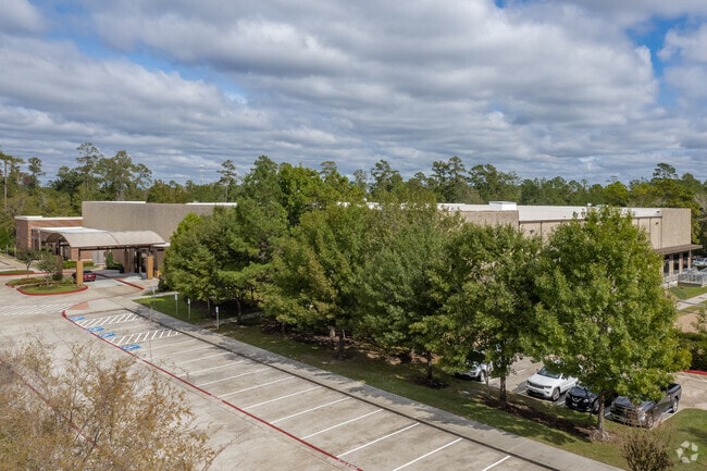
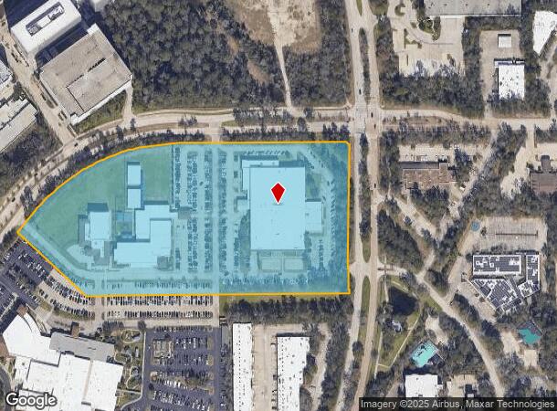
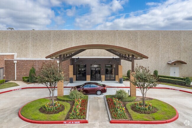
Property Record
9201 Grogans Mill Rd, Spring, TX 77380

Property Detail
9201 Grogans Mill Rd
9292-01-00100
S929201 - THE WOODLANDS UNITED METHODIST CHURCH, RES A, ACRES 13.83
Commercialnec
MONTGOMERY
B and X Area of moderate flood hazard, usually the area between the limits of the 100-year and 500-year floods.
Texas
0
13.83 AC
2025
The Woodlands
691700
Houston
129,086 SF
Houston-Pasadena-The Woodlands, TX
NEARBY LISTINGS FOR SALE OR LEASE
-
-
View all Spring listings for sale on LoopNet.com
DEMOGRAPHICS near 9201 Grogans Mill Rd
1 mile
3 mile
5 mile
2025 Total Population
7,238
70,580
181,260
2030 Population
8,598
82,163
208,754
Pop Growth 2025-2030
+ 18.79%
+ 16.41%
+ 15.17%
Average Age
46
41
39
2025 Total Households
3,556
29,766
69,779
HH Growth 2025-2030
+ 19.77%
+ 17.12%
+ 15.93%
Median Household Inc
$114,697
$93,775
$106,286
Avg Household Size
2.00
2.30
2.60
2025 Avg HH Vehicles
2.00
2.00
2.00
Median Home Value
$708,049
$397,355
$396,297
Median Year Built
2010
1994
2003
Nearby Places
Map Layers
Map Styles
 Street
 Aerial
Transit
 Traffic
 Biking
Places
Listings with unknown addresses are not visible on the map
- Restaurants
- Banks
- Shops
- Fitness
- Groceries
PUBLIC TRANSPORTATION
AIRPORT
George Bush Intcntl/Houston
Drive
Walk
Distance
George Bush Intcntl/Houston
29 min
22.3 mi
Nearby Properties
Address
Land Use
TOTAL SIZE
Lot Size
Zoning
Address
Land Use
TOTAL SIZE
Lot Size
Zoning
1,416,950 SF
21.80 AC
Address
Land Use
TOTAL SIZE
Lot Size
Zoning
1,673,574 SF
5.10 AC
Address
Land Use
TOTAL SIZE
Lot Size
Zoning
855,268 SF
31.65 AC
6
Address
Land Use
TOTAL SIZE
Lot Size
Zoning
743,246 SF
40.65 AC
Address
Land Use
TOTAL SIZE
Lot Size
Zoning
465,986 SF
21.55 AC
Address
Land Use
TOTAL SIZE
Lot Size
Zoning
718,313 SF
33.62 AC
Address
Land Use
TOTAL SIZE
Lot Size
Zoning
709,789 SF
3.04 AC
Address
Land Use
TOTAL SIZE
Lot Size
Zoning
1,053,284 SF
2.25 AC
Address
Land Use
TOTAL SIZE
Lot Size
Zoning
707,184 SF
3.48 AC
Address
Land Use
TOTAL SIZE
Lot Size
Zoning
813,318 SF
20.95 AC
Address
Land Use
TOTAL SIZE
Lot Size
Zoning
565,113 SF
4.52 AC
Address
Land Use
TOTAL SIZE
Lot Size
Zoning
469,813 SF
3.16 AC
Address
Land Use
TOTAL SIZE
Lot Size
Zoning
225,149 SF
1.07 AC
Address
Land Use
TOTAL SIZE
Lot Size
Zoning
670,665 SF
6.70 AC
Address
Land Use
TOTAL SIZE
Lot Size
Zoning
370,039 SF
40.66 AC
Address
Land Use
TOTAL SIZE
Lot Size
Zoning
571,041 SF
4.82 AC
Address
Land Use
TOTAL SIZE
Lot Size
Zoning
438,062 SF
4.54 AC
Address
Land Use
TOTAL SIZE
Lot Size
Zoning
1,132,062 SF
3.31 AC
Address
Land Use
TOTAL SIZE
Lot Size
Zoning
410,156 SF
18.68 AC
Address
Land Use
TOTAL SIZE
Lot Size
Zoning
327,377 SF
24.02 AC
6
Address
Land Use
TOTAL SIZE
Lot Size
Zoning
579,596 SF
1.32 AC
Address
Land Use
TOTAL SIZE
Lot Size
Zoning
473,060 SF
10.07 AC
Address
Land Use
TOTAL SIZE
Lot Size
Zoning
327,018 SF
21.91 AC
6
Address
Land Use
TOTAL SIZE
Lot Size
Zoning
392,960 SF
20.01 AC
6
Address
Land Use
TOTAL SIZE
Lot Size
Zoning
514,121 SF
2.01 AC
Address
Land Use
TOTAL SIZE
Lot Size
Zoning
279,413 SF
12.45 AC
6
Address
Land Use
TOTAL SIZE
Lot Size
Zoning
336,730 SF
2.41 AC
Address
Land Use
TOTAL SIZE
Lot Size
Zoning
383,484 SF
4.67 AC
Address
Land Use
TOTAL SIZE
Lot Size
Zoning
246,719 SF
1.25 AC
Address
Land Use
TOTAL SIZE
Lot Size
Zoning
880,985 SF
99.32 AC
6
The World's #1 Commercial Real Estate Marketplace
Connect with us
© 2026 CoStar Group
The information above has been obtained from sources believed reliable. While we do not doubt its accuracy we have not verified it and make no guarantee, warranty or representation about it. It is your responsibility to independently confirm its accuracy and completeness. Any projections, opinions, assumptions, or estimates used are for example only and do not represent the current or future performance of the property. The value of this transaction to you depends on tax and other factors which should be evaluated by your tax, financial, and legal advisors. You and your advisors should conduct a careful, independent investigation of the property to determine to your satisfaction the suitability of the property for your needs.