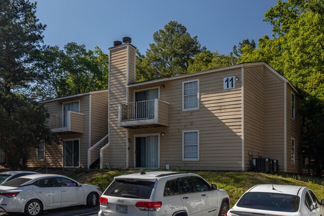
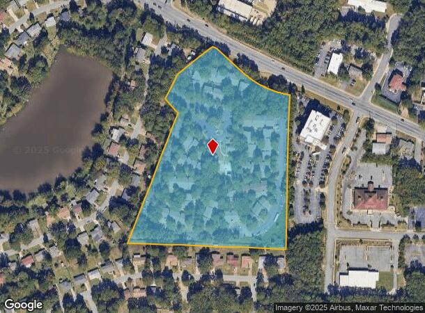
Property Record
9201 Kanis Rd, Little Rock, AR 72205
NEARBY LISTINGS FOR SALE OR LEASE
Property Detail
9201 Kanis Rd
Little Rock-North Little Rock-Conway, AR
12Th St Apt Sub
44L-081-01-002-00
LOT 1 OF 12TH ST APT SUBDIVISION
Officebuilding
Pulaski
X
Arkansas
05125C0250E
1
2025
11.24 AC
2025
Briarwood
002409
Little Rock/N Little Rock
90,844 SF
DEMOGRAPHICS near 9201 Kanis Rd
1 Mile
3 Mile
5 Mile
2024 Total Population
7,939
75,746
142,253
2029 Population
7,939
75,750
142,398
Pop Growth 2024-2029
0.00%
+ 0.01%
+ 0.10%
Average Age
40
39
39
2024 Total Households
3,596
34,750
62,928
HH Growth 2024-2029
(0.03%)
+ 0.01%
+ 0.09%
Median Household Inc
$38,191
$50,388
$54,565
Avg Household Size
2.10
2.10
2.10
2024 Avg HH Vehicles
1.00
2.00
2.00
Median Home Value
$137,952
$175,248
$191,100
Median Year Built
1975
1975
1976
Nearby Places
Map Layers
Map Styles
 Street
 Aerial
- Restaurants
- Banks
- Shops
- Fitness
- Groceries
PUBLIC TRANSPORTATION
COMMUTER RAIL
Little Rock Union Station (Texas Eagle - Amtrak)
DRIVE
WALK
Distance
Little Rock Union Station (Texas Eagle - Amtrak)
11 min
6.3 mi
AIRPORT
Bill and Hillary Clinton Ntl/Adams Field
DRIVE
WALK
Distance
Bill and Hillary Clinton Ntl/Adams Field
17 min
11.0 mi
Freight Ports
Port of Shreveport
DRIVE
WALK
Distance
Port of Shreveport
247 min
229.2 mi
Nearby Properties
Address
Land Use
TOTAL SIZE
Lot Size
Zoning
Address
Land Use
TOTAL SIZE
Lot Size
Zoning
1,665,090 SF
34.75 AC
Address
Land Use
TOTAL SIZE
Lot Size
Zoning
1,909,430 SF
29.12 AC
Address
Land Use
TOTAL SIZE
Lot Size
Zoning
227,729 SF
36.49 AC
Address
Land Use
TOTAL SIZE
Lot Size
Zoning
115,378 SF
30.50 AC
Address
Land Use
TOTAL SIZE
Lot Size
Zoning
143,885 SF
14.98 AC
Address
Land Use
TOTAL SIZE
Lot Size
Zoning
145,580 SF
19.89 AC
Address
Land Use
TOTAL SIZE
Lot Size
Zoning
39,635 SF
15.76 AC
Address
Land Use
TOTAL SIZE
Lot Size
Zoning
35,086 SF
6.48 AC
Address
Land Use
TOTAL SIZE
Lot Size
Zoning
220,563 SF
12.36 AC
Address
Land Use
TOTAL SIZE
Lot Size
Zoning
140,675 SF
Address
Land Use
TOTAL SIZE
Lot Size
Zoning
130,800 SF
7.78 AC
Address
Land Use
TOTAL SIZE
Lot Size
Zoning
221,911 SF
10.31 AC
Address
Land Use
TOTAL SIZE
Lot Size
Zoning
168,041 SF
29.22 AC
Address
Land Use
TOTAL SIZE
Lot Size
Zoning
57,494 SF
9.53 AC
Address
Land Use
TOTAL SIZE
Lot Size
Zoning
19,142 SF
5.54 AC
Address
Land Use
TOTAL SIZE
Lot Size
Zoning
221,204 SF
4.54 AC
Address
Land Use
TOTAL SIZE
Lot Size
Zoning
318,188 SF
8.86 AC
Address
Land Use
TOTAL SIZE
Lot Size
Zoning
210,924 SF
22.66 AC
Address
Land Use
TOTAL SIZE
Lot Size
Zoning
54,284 SF
11.33 AC
Address
Land Use
TOTAL SIZE
Lot Size
Zoning
63,244 SF
14.21 AC
Address
Land Use
TOTAL SIZE
Lot Size
Zoning
404,617 SF
9.51 AC
Address
Land Use
TOTAL SIZE
Lot Size
Zoning
185,873 SF
Address
Land Use
TOTAL SIZE
Lot Size
Zoning
78,004 SF
4.44 AC
Address
Land Use
TOTAL SIZE
Lot Size
Zoning
48,470 SF
26.37 AC
Address
Land Use
TOTAL SIZE
Lot Size
Zoning
74,220 SF
15.49 AC
Address
Land Use
TOTAL SIZE
Lot Size
Zoning
14,902 SF
5.04 AC
Address
Land Use
TOTAL SIZE
Lot Size
Zoning
122,775 SF
9.96 AC
Address
Land Use
TOTAL SIZE
Lot Size
Zoning
88,687 SF
1.67 AC
Address
Land Use
TOTAL SIZE
Lot Size
Zoning
155,943 SF
10.59 AC
Address
Land Use
TOTAL SIZE
Lot Size
Zoning
52,577 SF
The World's #1 Commercial Real Estate Marketplace
Connect with us
© 2026 CoStar Group
The information above has been obtained from sources believed reliable. While we do not doubt its accuracy we have not verified it and make no guarantee, warranty or representation about it. It is your responsibility to independently confirm its accuracy and completeness. Any projections, opinions, assumptions, or estimates used are for example only and do not represent the current or future performance of the property. The value of this transaction to you depends on tax and other factors which should be evaluated by your tax, financial, and legal advisors. You and your advisors should conduct a careful, independent investigation of the property to determine to your satisfaction the suitability of the property for your needs.