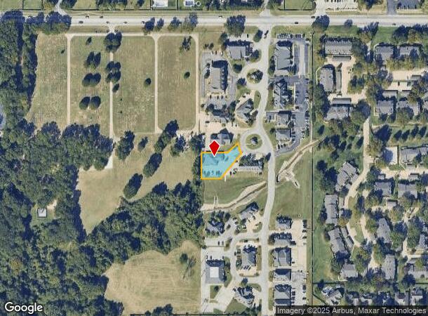
Property Record
9206 S Toledo Ave, Tulsa, OK 74137
NEARBY LISTINGS FOR SALE OR LEASE
Property Detail
9206 S Toledo Ave
Tulsa, OK
Ashton Creek Office Park
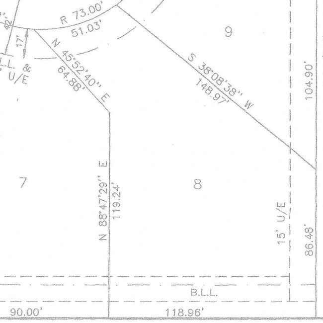
70021-83-21-00090
LT 8 BLK 1
Officebuilding
Tulsa
X
Oklahoma
40143C0368L
8
2025
0.40 AC
2025
South Central
007634
Tulsa
3,832 SF
DEMOGRAPHICS near 9206 S Toledo Ave
1 Mile
3 Mile
5 Mile
2024 Total Population
7,709
77,111
197,056
2029 Population
7,893
79,467
203,782
Pop Growth 2024-2029
+ 2.39%
+ 3.06%
+ 3.41%
Average Age
43
40
39
2024 Total Households
3,216
32,114
82,442
HH Growth 2024-2029
+ 2.49%
+ 3.05%
+ 3.40%
Median Household Inc
$97,206
$72,953
$67,911
Avg Household Size
2.30
2.30
2.30
2024 Avg HH Vehicles
2.00
2.00
2.00
Median Home Value
$304,344
$287,483
$261,090
Median Year Built
1987
1985
1984
Nearby Places
Map Layers
Map Styles
 Street
 Aerial
- Restaurants
- Banks
- Shops
- Fitness
- Groceries
PUBLIC TRANSPORTATION
AIRPORT
Tulsa International
DRIVE
WALK
Distance
Tulsa International
28 min
20.3 mi
Freight Ports
DRIVE
WALK
Distance
32 min
24.0 mi
Nearby Properties
Address
Land Use
TOTAL SIZE
Lot Size
Zoning
Address
Land Use
TOTAL SIZE
Lot Size
Zoning
2,622,731 SF
26.90 AC
OH
Address
Land Use
TOTAL SIZE
Lot Size
Zoning
1,584,609 SF
84.41 AC
AG
Address
Land Use
TOTAL SIZE
Lot Size
Zoning
717,386 SF
49.74 AC
OL
Address
Land Use
TOTAL SIZE
Lot Size
Zoning
790,247 SF
149.86 AC
RS3
Address
Land Use
TOTAL SIZE
Lot Size
Zoning
358,576 SF
38.21 AC
RM1
Address
Land Use
TOTAL SIZE
Lot Size
Zoning
236,738 SF
11.56 AC
PUD
Address
Land Use
TOTAL SIZE
Lot Size
Zoning
139,648 SF
20.75 AC
RS3
Address
Land Use
TOTAL SIZE
Lot Size
Zoning
61,153 SF
7.16 AC
CH
Address
Land Use
TOTAL SIZE
Lot Size
Zoning
206,760 SF
78.45 AC
AG
Address
Land Use
TOTAL SIZE
Lot Size
Zoning
163,472 SF
29.92 AC
AG
Address
Land Use
TOTAL SIZE
Lot Size
Zoning
325 SF
44.06 AC
RM2
Address
Land Use
TOTAL SIZE
Lot Size
Zoning
72,042 SF
5.10 AC
RS3
Address
Land Use
TOTAL SIZE
Lot Size
Zoning
6,338 SF
104.15 AC
AG
Address
Land Use
TOTAL SIZE
Lot Size
Zoning
98,590 SF
6.41 AC
OM
Address
Land Use
TOTAL SIZE
Lot Size
Zoning
55,384 SF
14.81 AC
AG
Address
Land Use
TOTAL SIZE
Lot Size
Zoning
107,538 SF
19.74 AC
OM
Address
Land Use
TOTAL SIZE
Lot Size
Zoning
58,977 SF
15.85 AC
CS
Address
Land Use
TOTAL SIZE
Lot Size
Zoning
8,388 SF
63.49 AC
AG
Address
Land Use
TOTAL SIZE
Lot Size
Zoning
176,243 SF
5.77 AC
CS
Address
Land Use
TOTAL SIZE
Lot Size
Zoning
56,984 SF
5.54 AC
RS3
Address
Land Use
TOTAL SIZE
Lot Size
Zoning
65,385 SF
16.59 AC
AG
Address
Land Use
TOTAL SIZE
Lot Size
Zoning
65,812 SF
14.12 AC
RS1
Address
Land Use
TOTAL SIZE
Lot Size
Zoning
62,792 SF
5.18 AC
RM1
Address
Land Use
TOTAL SIZE
Lot Size
Zoning
33,668 SF
8.04 AC
CO
Address
Land Use
TOTAL SIZE
Lot Size
Zoning
27,278 SF
2.49 AC
CS
Address
Land Use
TOTAL SIZE
Lot Size
Zoning
98,290 SF
19.62 AC
RS3
Address
Land Use
TOTAL SIZE
Lot Size
Zoning
86,747 SF
19.01 AC
RS3
Address
Land Use
TOTAL SIZE
Lot Size
Zoning
365,433 SF
18.39 AC
CO
Address
Land Use
TOTAL SIZE
Lot Size
Zoning
24,134 SF
7.47 AC
OM
Address
Land Use
TOTAL SIZE
Lot Size
Zoning
35,785 SF
4.55 AC
RS1
The World's #1 Commercial Real Estate Marketplace
Connect with us
© 2025 CoStar Group
The information above has been obtained from sources believed reliable. While we do not doubt its accuracy we have not verified it and make no guarantee, warranty or representation about it. It is your responsibility to independently confirm its accuracy and completeness. Any projections, opinions, assumptions, or estimates used are for example only and do not represent the current or future performance of the property. The value of this transaction to you depends on tax and other factors which should be evaluated by your tax, financial, and legal advisors. You and your advisors should conduct a careful, independent investigation of the property to determine to your satisfaction the suitability of the property for your needs.