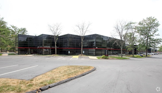
Property Record
921 Eastwind Dr, Westerville, OH 43081


NEARBY LISTINGS FOR SALE OR LEASE
Property Detail
921 Eastwind Dr
080-007421
Westerwood Office Park Phase 5
Officebuilding
921-29 EASTWIND DR R17 T2 1/4T2 8.979 ACRES
X
Franklin
39049C0181K
Ohio
2024
8.98 AC
2024
Westerville
007101
Columbus
107,642 SF
Columbus, OH
DEMOGRAPHICS near 921 Eastwind Dr
1 Mile
3 Mile
5 Mile
2024 Total Population
10,709
97,089
257,220
2029 Population
10,621
97,622
260,632
Pop Growth 2024-2029
(0.82%)
+ 0.55%
+ 1.33%
Average Age
40
38
38
2024 Total Households
4,241
38,558
104,648
HH Growth 2024-2029
(0.85%)
+ 0.64%
+ 1.31%
Median Household Inc
$82,023
$71,396
$73,705
Avg Household Size
2.50
2.40
2.40
2024 Avg HH Vehicles
2.00
2.00
2.00
Median Home Value
$222,867
$249,077
$257,869
Median Year Built
1975
1978
1985
Nearby Places
Map Layers
Map Styles
 Street
 Aerial
- Restaurants
- Banks
- Shops
- Fitness
- Groceries
PUBLIC TRANSPORTATION
AIRPORT
John Glenn Columbus International
DRIVE
WALK
Distance
John Glenn Columbus International
15 min
11.2 mi
Freight Ports
Port of Baltimore
DRIVE
WALK
Distance
Port of Baltimore
1 min
340.9 mi
SALE & LEASE HISTORY
LISTING DATE
SALE/LEASE

Sep 25, 2016
For Lease
Aug 09, 2023
For Sale
Apr 03, 2025
For Lease
Nearby Properties
Address
Land Use
TOTAL SIZE
Lot Size
Zoning
Address
Land Use
TOTAL SIZE
Lot Size
Zoning
440,828 SF
13.72 AC
Address
Land Use
TOTAL SIZE
Lot Size
Zoning
426,490 SF
19.43 AC
Address
Land Use
TOTAL SIZE
Lot Size
Zoning
446,516 SF
95.88 AC
Address
Land Use
TOTAL SIZE
Lot Size
Zoning
697,077 SF
40.91 AC
Address
Land Use
TOTAL SIZE
Lot Size
Zoning
45,135 SF
22.02 AC
Address
Land Use
TOTAL SIZE
Lot Size
Zoning
159,315 SF
13.25 AC
Address
Land Use
TOTAL SIZE
Lot Size
Zoning
165,944 SF
14.21 AC
Address
Land Use
TOTAL SIZE
Lot Size
Zoning
3,263 SF
989.66 AC
Address
Land Use
TOTAL SIZE
Lot Size
Zoning
152,684 SF
20.94 AC
Address
Land Use
TOTAL SIZE
Lot Size
Zoning
201,072 SF
22.28 AC
Address
Land Use
TOTAL SIZE
Lot Size
Zoning
292,377 SF
36.29 AC
Address
Land Use
TOTAL SIZE
Lot Size
Zoning
150,718 SF
4.35 AC
Address
Land Use
TOTAL SIZE
Lot Size
Zoning
170,259 SF
16.30 AC
Address
Land Use
TOTAL SIZE
Lot Size
Zoning
137,489 SF
14.73 AC
Address
Land Use
TOTAL SIZE
Lot Size
Zoning
194,750 SF
13.53 AC
Address
Land Use
TOTAL SIZE
Lot Size
Zoning
119,213 SF
25.43 AC
Address
Land Use
TOTAL SIZE
Lot Size
Zoning
236,681 SF
7.83 AC
Address
Land Use
TOTAL SIZE
Lot Size
Zoning
142,998 SF
30.25 AC
Address
Land Use
TOTAL SIZE
Lot Size
Zoning
100,848 SF
9.72 AC
Address
Land Use
TOTAL SIZE
Lot Size
Zoning
89,544 SF
4.82 AC
Address
Land Use
TOTAL SIZE
Lot Size
Zoning
27,978 SF
11.35 AC
Address
Land Use
TOTAL SIZE
Lot Size
Zoning
172,848 SF
5.34 AC
Address
Land Use
TOTAL SIZE
Lot Size
Zoning
122,920 SF
20.30 AC
Address
Land Use
TOTAL SIZE
Lot Size
Zoning
362,014 SF
37.08 AC
Address
Land Use
TOTAL SIZE
Lot Size
Zoning
85,228 SF
45.03 AC
Address
Land Use
TOTAL SIZE
Lot Size
Zoning
30,383 SF
20.72 AC
Address
Land Use
TOTAL SIZE
Lot Size
Zoning
61,326 SF
15.78 AC
Address
Land Use
TOTAL SIZE
Lot Size
Zoning
42,108 SF
27.10 AC
Address
Land Use
TOTAL SIZE
Lot Size
Zoning
46,080 SF
13.23 AC
Address
Land Use
TOTAL SIZE
Lot Size
Zoning
74,544 SF
10.52 AC
The World's #1 Commercial Real Estate Marketplace
Connect with us
© 2026 CoStar Group
The information above has been obtained from sources believed reliable. While we do not doubt its accuracy we have not verified it and make no guarantee, warranty or representation about it. It is your responsibility to independently confirm its accuracy and completeness. Any projections, opinions, assumptions, or estimates used are for example only and do not represent the current or future performance of the property. The value of this transaction to you depends on tax and other factors which should be evaluated by your tax, financial, and legal advisors. You and your advisors should conduct a careful, independent investigation of the property to determine to your satisfaction the suitability of the property for your needs.