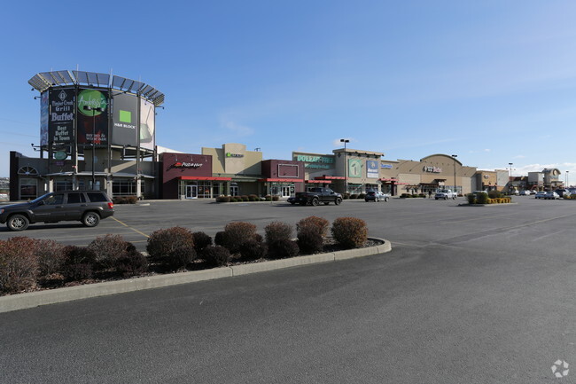
Property Record
9211 E Montgomery Ave, Spokane Valley, WA 99206

NEARBY LISTINGS FOR SALE OR LEASE
Property Detail
9211 E Montgomery Ave
Spokane-Spokane Valley, WA
Warrens 05 Acre Tracts
45082.1849
NW1/4 08-25-44 WARRENS FIVE ACRE TRACTS 11 & 12 EXC. W. 15 FT ALSO EXC S. 169.96 FT OF TRACT 11 ALSO EXC. THAT PTN DESC AS FOLLOWS: BEGINNING AT THE NE COR OF TRACT 12; TH S74DEG00MIN38SEC W ALG N LN OF SD TRACT 12 113.84 FT; TH S 00DEG07MIN13SEC E 4
Storebuilding
Spokane
X
Washington
53063C0566D
11,12
2025
4.42 AC
2025
Valley
011701
Spokane
48,754 SF
DEMOGRAPHICS near 9211 E Montgomery Ave
1 Mile
3 Mile
5 Mile
2024 Total Population
7,759
62,304
150,647
2029 Population
8,216
66,327
160,601
Pop Growth 2024-2029
+ 5.89%
+ 6.46%
+ 6.61%
Average Age
41
40
40
2024 Total Households
3,262
25,986
59,943
HH Growth 2024-2029
+ 5.89%
+ 6.62%
+ 6.76%
Median Household Inc
$59,979
$60,196
$62,704
Avg Household Size
2.30
2.30
2.40
2024 Avg HH Vehicles
2.00
2.00
2.00
Median Home Value
$297,387
$302,655
$314,929
Median Year Built
1961
1977
1976
Nearby Places
Map Layers
Map Styles
 Street
 Aerial
- Restaurants
- Banks
- Shops
- Fitness
- Groceries
PUBLIC TRANSPORTATION
COMMUTER RAIL
Spokane (Empire Builder - Amtrak)
DRIVE
WALK
Distance
Spokane (Empire Builder - Amtrak)
13 min
7.6 mi
AIRPORT
Spokane International
DRIVE
WALK
Distance
Spokane International
21 min
13.5 mi
Freight Ports
Port of Everett
DRIVE
WALK
Distance
Port of Everett
348 min
309.0 mi
Nearby Properties
Address
Land Use
TOTAL SIZE
Lot Size
Zoning
Address
Land Use
TOTAL SIZE
Lot Size
Zoning
355,192 SF
35.83 AC
I-2
Address
Land Use
TOTAL SIZE
Lot Size
Zoning
169,003 SF
5.18 AC
MUC
Address
Land Use
TOTAL SIZE
Lot Size
Zoning
259,169 SF
13.42 AC
MF-2
Address
Land Use
TOTAL SIZE
Lot Size
Zoning
318,756 SF
13.64 AC
MF-2
Address
Land Use
TOTAL SIZE
Lot Size
Zoning
378,750 SF
17.38 AC
R-2
Address
Land Use
TOTAL SIZE
Lot Size
Zoning
204,730 SF
8.60 AC
MUC
Address
Land Use
TOTAL SIZE
Lot Size
Zoning
161,130 SF
6.45 AC
GO
Address
Land Use
TOTAL SIZE
Lot Size
Zoning
84,600 SF
17.95 AC
MF-1
Address
Land Use
TOTAL SIZE
Lot Size
Zoning
136,518 SF
7.96 AC
O
Address
Land Use
TOTAL SIZE
Lot Size
Zoning
175,936 SF
12.16 AC
MF-2
Address
Land Use
TOTAL SIZE
Lot Size
Zoning
87,848 SF
7.36 AC
MF-2
Address
Land Use
TOTAL SIZE
Lot Size
Zoning
72,443 SF
8.90 AC
R-3
Address
Land Use
TOTAL SIZE
Lot Size
Zoning
87,989 SF
5.38 AC
MF-2
Address
Land Use
TOTAL SIZE
Lot Size
Zoning
151,690 SF
7.89 AC
MF-2
Address
Land Use
TOTAL SIZE
Lot Size
Zoning
61,059 SF
54.20 AC
P/OS
Address
Land Use
TOTAL SIZE
Lot Size
Zoning
143,772 SF
10.67 AC
MF-2
Address
Land Use
TOTAL SIZE
Lot Size
Zoning
157,232 SF
3.28 AC
MF-2
Address
Land Use
TOTAL SIZE
Lot Size
Zoning
96,424 SF
9.04 AC
I-1
Address
Land Use
TOTAL SIZE
Lot Size
Zoning
120,296 SF
9.26 AC
MF-2
Address
Land Use
TOTAL SIZE
Lot Size
Zoning
115,536 SF
6.17 AC
MUC
Address
Land Use
TOTAL SIZE
Lot Size
Zoning
139,164 SF
5.62 AC
MUC
Address
Land Use
TOTAL SIZE
Lot Size
Zoning
47,612 SF
3.38 AC
CMU
Address
Land Use
TOTAL SIZE
Lot Size
Zoning
134,104 SF
5.89 AC
HDR
Address
Land Use
TOTAL SIZE
Lot Size
Zoning
89,120 SF
5.83 AC
MDR
Address
Land Use
TOTAL SIZE
Lot Size
Zoning
123,938 SF
7.70 AC
MF-2
Address
Land Use
TOTAL SIZE
Lot Size
Zoning
76,190 SF
4.03 AC
MUC
Address
Land Use
TOTAL SIZE
Lot Size
Zoning
118,818 SF
7.96 AC
HDR
Address
Land Use
TOTAL SIZE
Lot Size
Zoning
72,903 SF
6.35 AC
MF-2
Address
Land Use
TOTAL SIZE
Lot Size
Zoning
118,810 SF
11.23 AC
MUC
Address
Land Use
TOTAL SIZE
Lot Size
Zoning
150,715 SF
7.82 AC
MF-2
The World's #1 Commercial Real Estate Marketplace
Connect with us
© 2026 CoStar Group
The information above has been obtained from sources believed reliable. While we do not doubt its accuracy we have not verified it and make no guarantee, warranty or representation about it. It is your responsibility to independently confirm its accuracy and completeness. Any projections, opinions, assumptions, or estimates used are for example only and do not represent the current or future performance of the property. The value of this transaction to you depends on tax and other factors which should be evaluated by your tax, financial, and legal advisors. You and your advisors should conduct a careful, independent investigation of the property to determine to your satisfaction the suitability of the property for your needs.