Property Record
8629 Bay Pkwy, Brooklyn, NY 11214
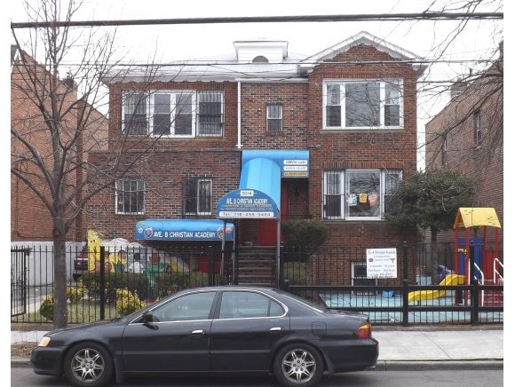

This Property Is For Sale
Current Lease Availabilities
NEARBY LISTINGS FOR SALE OR LEASE
Property Detail
8629 Bay Pkwy
06381-1036
DOCID-2019020700335001ADDL BLK-LOT: 6381-1057,1076
Condominium
Kings
X
New York
3604970351F
1036
2024
0.27 AC
2025
South Brooklyn
029600
Long Island (New York)
753 SF
New York-Jersey City-White Plains, NY-NJ
DEMOGRAPHICS near 8629 Bay Pkwy
1 mile
3 mile
5 mile
2024 Total Population
106,563
952,326
2,274,616
2029 Population
97,661
887,445
2,122,460
Pop Growth 2024-2029
(8.35%)
(6.81%)
(6.69%)
Average Age
41
40
38
2024 Total Households
36,708
345,603
816,487
HH Growth 2024-2029
(8.91%)
(7.18%)
(7.02%)
Median Household Inc
$50,663
$60,257
$68,807
Avg Household Size
2.70
2.60
2.70
2024 Avg HH Vehicles
1.00
1.00
1.00
Median Home Value
$602,354
$729,297
$797,741
Median Year Built
1948
1948
1948
Nearby Places
Map Layers
Map Styles
 Street
 Aerial
Transit
 Traffic
 Biking
Places
Listings with unknown addresses are not visible on the map
- Restaurants
- Banks
- Shops
- Fitness
- Groceries
PUBLIC TRANSPORTATION
TRANSIT/SUBWAY
Bay Parkway (D,M Line) (D - New York MTA Subway (The Subway), M - New York MTA Subway (The Subway))
Drive
Walk
Distance
Bay Parkway (D,M Line) (D - New York MTA Subway (The Subway), M - New York MTA Subway (The Subway))
1 min
1 min
0.1 mi
20 Avenue (D,M Line) (D - New York MTA Subway (The Subway), M - New York MTA Subway (The Subway))
Drive
Walk
Distance
20 Avenue (D,M Line) (D - New York MTA Subway (The Subway), M - New York MTA Subway (The Subway))
2 min
7 min
0.4 mi
25 Avenue (D - New York MTA Subway (The Subway))
Drive
Walk
Distance
25 Avenue (D - New York MTA Subway (The Subway))
1 min
9 min
0.5 mi
18 Avenue (D,M Line) (D - New York MTA Subway (The Subway), M - New York MTA Subway (The Subway))
Drive
Walk
Distance
18 Avenue (D,M Line) (D - New York MTA Subway (The Subway), M - New York MTA Subway (The Subway))
2 min
13 min
0.7 mi
Kings Highway (N Line) (N - New York MTA Subway (The Subway))
Drive
Walk
Distance
Kings Highway (N Line) (N - New York MTA Subway (The Subway))
2 min
18 min
0.9 mi
COMMUTER RAIL
Grasmere (Staten Island Railway - New York MTA Subway (The Subway))
Drive
Walk
Distance
Grasmere (Staten Island Railway - New York MTA Subway (The Subway))
13 min
6.6 mi
Old Town (Staten Island Railway - New York MTA Subway (The Subway))
Drive
Walk
Distance
Old Town (Staten Island Railway - New York MTA Subway (The Subway))
14 min
6.7 mi
AIRPORT
John F Kennedy International
Drive
Walk
Distance
John F Kennedy International
28 min
14.9 mi
LaGuardia
Drive
Walk
Distance
LaGuardia
33 min
18.1 mi
Newark Liberty International
Drive
Walk
Distance
Newark Liberty International
34 min
21.7 mi
Freight Ports
NY - Red Hook Container Terminal
Drive
Walk
Distance
NY - Red Hook Container Terminal
13 min
7.0 mi
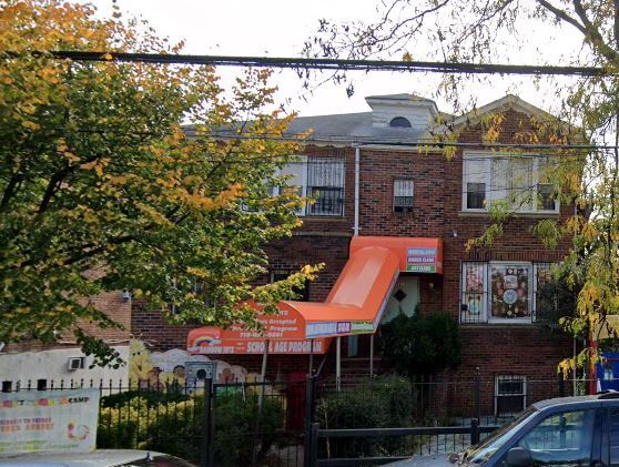
Nearby Properties
Address
Land Use
TOTAL SIZE
Lot Size
Zoning
Address
Land Use
TOTAL SIZE
Lot Size
Zoning
1,524,659 SF
170.96 AC
R4
Address
Land Use
TOTAL SIZE
Lot Size
Zoning
1,078,317 SF
10.45 AC
R4
Address
Land Use
TOTAL SIZE
Lot Size
Zoning
5,800 SF
20.10 AC
R6
Address
Land Use
TOTAL SIZE
Lot Size
Zoning
5,800 SF
20.10 AC
R6
Address
Land Use
TOTAL SIZE
Lot Size
Zoning
5,800 SF
20.10 AC
R6
Address
Land Use
TOTAL SIZE
Lot Size
Zoning
5,800 SF
20.10 AC
R6
Address
Land Use
TOTAL SIZE
Lot Size
Zoning
5,800 SF
20.10 AC
R6
Address
Land Use
TOTAL SIZE
Lot Size
Zoning
5,800 SF
20.10 AC
R6
Address
Land Use
TOTAL SIZE
Lot Size
Zoning
5,800 SF
20.10 AC
R6
Address
Land Use
TOTAL SIZE
Lot Size
Zoning
5,800 SF
20.10 AC
R6
Address
Land Use
TOTAL SIZE
Lot Size
Zoning
5,800 SF
20.10 AC
R6
Address
Land Use
TOTAL SIZE
Lot Size
Zoning
12.39 AC
R6
Address
Land Use
TOTAL SIZE
Lot Size
Zoning
965,600 SF
6.65 AC
R5
Address
Land Use
TOTAL SIZE
Lot Size
Zoning
335,800 SF
1.51 AC
R6
Address
Land Use
TOTAL SIZE
Lot Size
Zoning
54.78 AC
PARK
Address
Land Use
TOTAL SIZE
Lot Size
Zoning
785,450 SF
14.22 AC
R6
Address
Land Use
TOTAL SIZE
Lot Size
Zoning
340,068 SF
0.58 AC
C2-8
Address
Land Use
TOTAL SIZE
Lot Size
Zoning
340,068 SF
0.58 AC
C2-8
Address
Land Use
TOTAL SIZE
Lot Size
Zoning
1,800,000 SF
12.39 AC
R6
Address
Land Use
TOTAL SIZE
Lot Size
Zoning
1,736,700 SF
20.10 AC
R6
Address
Land Use
TOTAL SIZE
Lot Size
Zoning
753,367 SF
5.11 AC
R6
Address
Land Use
TOTAL SIZE
Lot Size
Zoning
623,806 SF
4.68 AC
R6
Address
Land Use
TOTAL SIZE
Lot Size
Zoning
623,806 SF
4.68 AC
R6
Address
Land Use
TOTAL SIZE
Lot Size
Zoning
623,806 SF
4.68 AC
R6
Address
Land Use
TOTAL SIZE
Lot Size
Zoning
623,806 SF
4.68 AC
R6
Address
Land Use
TOTAL SIZE
Lot Size
Zoning
623,806 SF
4.68 AC
R6
Address
Land Use
TOTAL SIZE
Lot Size
Zoning
623,806 SF
4.68 AC
R6
Address
Land Use
TOTAL SIZE
Lot Size
Zoning
623,806 SF
4.68 AC
R6
Address
Land Use
TOTAL SIZE
Lot Size
Zoning
623,806 SF
4.68 AC
R6
Address
Land Use
TOTAL SIZE
Lot Size
Zoning
623,806 SF
4.68 AC
R6
The World's #1 Commercial Real Estate Marketplace
Connect with us
© 2026 CoStar Group
The information above has been obtained from sources believed reliable. While we do not doubt its accuracy we have not verified it and make no guarantee, warranty or representation about it. It is your responsibility to independently confirm its accuracy and completeness. Any projections, opinions, assumptions, or estimates used are for example only and do not represent the current or future performance of the property. The value of this transaction to you depends on tax and other factors which should be evaluated by your tax, financial, and legal advisors. You and your advisors should conduct a careful, independent investigation of the property to determine to your satisfaction the suitability of the property for your needs.