Property Record
9214 Bonner Mill Rd, Bonner, MT 59823

Save to a Folder
{{folder.Name}}
{{folder.ListingIds.length}} Properties
{{folder.ListingIds.length}} Property
Create a New Folder
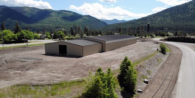
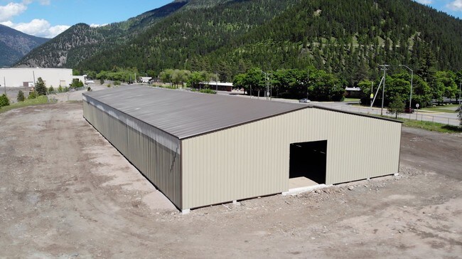
Property Detail
9214 Bonner Mill Rd
04-2201-21-4-01-21-0000
S21, T13 N, R18 W, C.O.S. 6487, PARCEL 25A, ACRES 31.38
Commercialnec
MISSOULA
B and X Area of moderate flood hazard, usually the area between the limits of the 100-year and 500-year floods.
Montana
2024
31.38 AC
2025
Missoula
001802
Other Market Areas
327,349 SF
Missoula, MT
NEARBY LISTINGS FOR SALE OR LEASE
DEMOGRAPHICS near 9214 Bonner Mill Rd
1 mile
3 mile
5 mile
2025 Total Population
737
2,770
10,510
2030 Population
720
2,767
10,537
Pop Growth 2025-2030
(2.31%)
(0.11%)
+ 0.26%
Average Age
41
42
42
2025 Total Households
296
1,182
4,502
HH Growth 2025-2030
(2.36%)
+ 0.17%
+ 0.38%
Median Household Inc
$72,804
$72,712
$82,843
Avg Household Size
2.30
2.20
2.20
2025 Avg HH Vehicles
2.00
2.00
2.00
Median Home Value
$410,417
$362,499
$552,442
Median Year Built
1978
1981
1978
Nearby Places
Map Layers
Map Styles
 Street
 Aerial
Layers
 Traffic
 Biking
Places
Listings with unknown addresses are not visible on the map
- Restaurants
- Banks
- Shops
- Fitness
- Groceries
PUBLIC TRANSPORTATION
AIRPORT
Missoula Montana
Drive
Walk
Distance
Missoula Montana
17 min
13.1 mi
Freight Ports
Port of Everett
Drive
Walk
Distance
Port of Everett
554 min
504.9 mi
SALE & LEASE HISTORY
LISTING DATE
SALE/LEASE

Jan 02, 2019
For Lease
Jan 01, 2019
For Lease
Nearby Properties
Address
Land Use
TOTAL SIZE
Lot Size
Zoning
Address
Land Use
TOTAL SIZE
Lot Size
Zoning
22,442 SF
0.70 AC
Address
Land Use
TOTAL SIZE
Lot Size
Zoning
191,956 SF
11.41 AC
Address
Land Use
TOTAL SIZE
Lot Size
Zoning
28,456 SF
25 AC
Address
Land Use
TOTAL SIZE
Lot Size
Zoning
34,183 SF
14.52 AC
Address
Land Use
TOTAL SIZE
Lot Size
Zoning
54,578 SF
20.54 AC
Address
Land Use
TOTAL SIZE
Lot Size
Zoning
38,626 SF
9.39 AC
Address
Land Use
TOTAL SIZE
Lot Size
Zoning
2,526 SF
37.46 AC
Address
Land Use
TOTAL SIZE
Lot Size
Zoning
56,877 SF
20.57 AC
Address
Land Use
TOTAL SIZE
Lot Size
Zoning
15,802 SF
276.43 AC
Address
Land Use
TOTAL SIZE
Lot Size
Zoning
82,779 SF
22.48 AC
Address
Land Use
TOTAL SIZE
Lot Size
Zoning
Address
Land Use
TOTAL SIZE
Lot Size
Zoning
75,234 SF
3.70 AC
Address
Land Use
TOTAL SIZE
Lot Size
Zoning
68,138 SF
1.88 AC
Address
Land Use
TOTAL SIZE
Lot Size
Zoning
4,579 SF
16.38 AC
Address
Land Use
TOTAL SIZE
Lot Size
Zoning
35,905 SF
2.28 AC
1
Address
Land Use
TOTAL SIZE
Lot Size
Zoning
200 SF
10 AC
1
Address
Land Use
TOTAL SIZE
Lot Size
Zoning
11.02 AC
Address
Land Use
TOTAL SIZE
Lot Size
Zoning
9,401 SF
5 AC
Address
Land Use
TOTAL SIZE
Lot Size
Zoning
5,956 SF
1.96 AC
Address
Land Use
TOTAL SIZE
Lot Size
Zoning
Address
Land Use
TOTAL SIZE
Lot Size
Zoning
10,996 SF
97.13 AC
Address
Land Use
TOTAL SIZE
Lot Size
Zoning
10 AC
1
Address
Land Use
TOTAL SIZE
Lot Size
Zoning
9,972 SF
1.85 AC
Address
Land Use
TOTAL SIZE
Lot Size
Zoning
8,418 SF
1.81 AC
Address
Land Use
TOTAL SIZE
Lot Size
Zoning
7,306 SF
1 AC
Address
Land Use
TOTAL SIZE
Lot Size
Zoning
27,450 SF
2 AC
1
Address
Land Use
TOTAL SIZE
Lot Size
Zoning
2,016 SF
4.37 AC
Address
Land Use
TOTAL SIZE
Lot Size
Zoning
12.97 AC
Address
Land Use
TOTAL SIZE
Lot Size
Zoning
26,100 SF
2.84 AC
The World's #1 Commercial Real Estate Marketplace
Connect with us
© 2026 CoStar Group
The information above has been obtained from sources believed reliable. While we do not doubt its accuracy we have not verified it and make no guarantee, warranty or representation about it. It is your responsibility to independently confirm its accuracy and completeness. Any projections, opinions, assumptions, or estimates used are for example only and do not represent the current or future performance of the property. The value of this transaction to you depends on tax and other factors which should be evaluated by your tax, financial, and legal advisors. You and your advisors should conduct a careful, independent investigation of the property to determine to your satisfaction the suitability of the property for your needs.