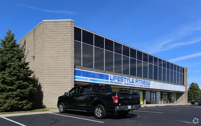
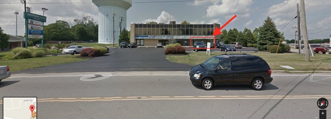
Property Record
9215 Cincinnati Columbus Rd, West Chester, OH 45069


NEARBY LISTINGS FOR SALE OR LEASE
Property Detail
9215 Cincinnati Columbus Rd
Cincinnati, OH-KY-IN
Pisgah Ind Park
M5620-091-000-017
2 PT PISGAH SEE TIF PCL 017T - CINCINNATI COLUMBUS RD TIF
Officebuilding
Butler
X
Ohio
39165C0203F
2
2024
0.79 AC
2025
Butler County
011110
Cincinnati/Dayton
9,881 SF
DEMOGRAPHICS near 9215 Cincinnati Columbus Rd
1 Mile
3 Mile
5 Mile
2024 Total Population
6,170
61,637
154,997
2029 Population
6,277
64,013
160,169
Pop Growth 2024-2029
+ 1.73%
+ 3.85%
+ 3.34%
Average Age
43
41
40
2024 Total Households
2,300
23,537
59,131
HH Growth 2024-2029
+ 1.65%
+ 3.68%
+ 3.23%
Median Household Inc
$112,652
$103,937
$103,695
Avg Household Size
2.60
2.50
2.60
2024 Avg HH Vehicles
2.00
2.00
2.00
Median Home Value
$248,746
$273,922
$290,459
Median Year Built
1977
1987
1988
Nearby Places
Map Layers
Map Styles
 Street
 Aerial
- Restaurants
- Banks
- Shops
- Fitness
- Groceries
PUBLIC TRANSPORTATION
AIRPORT
Cincinnati/Northern Kentucky International
DRIVE
WALK
Distance
Cincinnati/Northern Kentucky International
40 min
33.3 mi
Freight Ports
Virginia Port Authority - Richmond
DRIVE
WALK
Distance
Virginia Port Authority - Richmond
1 min
397.5 mi
SALE & LEASE HISTORY
LISTING DATE
SALE/LEASE

Feb 22, 2017
For Lease
Dec 09, 2017
For Lease
Dec 02, 2016
For Sale
Nearby Properties
Address
Land Use
TOTAL SIZE
Lot Size
Zoning
Address
Land Use
TOTAL SIZE
Lot Size
Zoning
232.72 AC
Address
Land Use
TOTAL SIZE
Lot Size
Zoning
21,549 SF
30.60 AC
Address
Land Use
TOTAL SIZE
Lot Size
Zoning
10.76 AC
Address
Land Use
TOTAL SIZE
Lot Size
Zoning
11.19 AC
Address
Land Use
TOTAL SIZE
Lot Size
Zoning
274,436 SF
27.12 AC
Address
Land Use
TOTAL SIZE
Lot Size
Zoning
17,484 SF
35.55 AC
Address
Land Use
TOTAL SIZE
Lot Size
Zoning
80,767 SF
7.31 AC
Address
Land Use
TOTAL SIZE
Lot Size
Zoning
287,883 SF
10.90 AC
Address
Land Use
TOTAL SIZE
Lot Size
Zoning
71,866 SF
14.33 AC
Address
Land Use
TOTAL SIZE
Lot Size
Zoning
Address
Land Use
TOTAL SIZE
Lot Size
Zoning
47,788 SF
25.84 AC
Address
Land Use
TOTAL SIZE
Lot Size
Zoning
7,230 SF
40 AC
Address
Land Use
TOTAL SIZE
Lot Size
Zoning
179,048 SF
12.32 AC
Address
Land Use
TOTAL SIZE
Lot Size
Zoning
28.73 AC
DD
Address
Land Use
TOTAL SIZE
Lot Size
Zoning
105,280 SF
10.76 AC
Address
Land Use
TOTAL SIZE
Lot Size
Zoning
105,280 SF
11.19 AC
Address
Land Use
TOTAL SIZE
Lot Size
Zoning
25,339 SF
14.59 AC
Address
Land Use
TOTAL SIZE
Lot Size
Zoning
Address
Land Use
TOTAL SIZE
Lot Size
Zoning
1,248 SF
21.67 AC
Address
Land Use
TOTAL SIZE
Lot Size
Zoning
85,759 SF
13.80 AC
Address
Land Use
TOTAL SIZE
Lot Size
Zoning
35,188 SF
38.49 AC
Address
Land Use
TOTAL SIZE
Lot Size
Zoning
Address
Land Use
TOTAL SIZE
Lot Size
Zoning
54.92 AC
Address
Land Use
TOTAL SIZE
Lot Size
Zoning
13,532 SF
3.19 AC
Address
Land Use
TOTAL SIZE
Lot Size
Zoning
158,680 SF
22.49 AC
Address
Land Use
TOTAL SIZE
Lot Size
Zoning
3,202 SF
3.34 AC
Address
Land Use
TOTAL SIZE
Lot Size
Zoning
17.10 AC
Address
Land Use
TOTAL SIZE
Lot Size
Zoning
317,346 SF
9.96 AC
Address
Land Use
TOTAL SIZE
Lot Size
Zoning
327,526 SF
22.42 AC
Address
Land Use
TOTAL SIZE
Lot Size
Zoning
14,970 SF
28.54 AC
The World's #1 Commercial Real Estate Marketplace
Connect with us
© 2026 CoStar Group
The information above has been obtained from sources believed reliable. While we do not doubt its accuracy we have not verified it and make no guarantee, warranty or representation about it. It is your responsibility to independently confirm its accuracy and completeness. Any projections, opinions, assumptions, or estimates used are for example only and do not represent the current or future performance of the property. The value of this transaction to you depends on tax and other factors which should be evaluated by your tax, financial, and legal advisors. You and your advisors should conduct a careful, independent investigation of the property to determine to your satisfaction the suitability of the property for your needs.