Property Record
922 Mayo Shell Rd, Galena Park, TX 77547
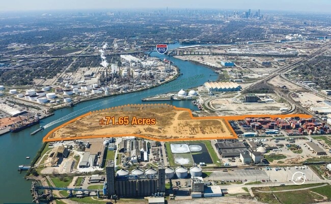


This Property Is For Sale
Current Lease Availabilities
Property Detail
922 Mayo Shell Rd
0410290010268
TR 1F (IMPS ONLY) (LAND*0410290010007) ABST 73 E THOMAS
Warehouse
HARRIS
AE The base floodplain where base flood elevations are provided. AE Zones are now used on new format FIRMs instead of A1-A30 Zones.
Texas
2025
70.30 AC
2025
Gulf Freeway/Pasadena
233702
Houston
8,400 SF
Houston-Pasadena-The Woodlands, TX
NEARBY LISTINGS FOR SALE OR LEASE
DEMOGRAPHICS near 922 Mayo Shell Rd
1 mile
3 mile
5 mile
2025 Total Population
3,855
85,220
296,205
2030 Population
4,124
91,494
316,722
Pop Growth 2025-2030
+ 6.98%
+ 7.36%
+ 6.93%
Average Age
36
36
36
2025 Total Households
1,166
26,888
95,578
HH Growth 2025-2030
+ 7.12%
+ 7.71%
+ 7.20%
Median Household Inc
$46,428
$51,748
$52,341
Avg Household Size
3.30
3.10
3.00
2025 Avg HH Vehicles
2.00
2.00
2.00
Median Home Value
$99,029
$152,912
$176,187
Median Year Built
1955
1958
1963
Nearby Places
Map Layers
Map Styles
 Street
 Aerial
Layers
 Traffic
 Biking
Places
Listings with unknown addresses are not visible on the map
- Restaurants
- Banks
- Shops
- Fitness
- Groceries
PUBLIC TRANSPORTATION
AIRPORT
William P Hobby
Drive
Walk
Distance
William P Hobby
26 min
11.8 mi
George Bush Intcntl/Houston
Drive
Walk
Distance
George Bush Intcntl/Houston
37 min
24.9 mi
Freight Ports
Port of Houston
Drive
Walk
Distance
Port of Houston
13 min
3.8 mi
Nearby Properties
Address
Land Use
TOTAL SIZE
Lot Size
Zoning
Address
Land Use
TOTAL SIZE
Lot Size
Zoning
65.22 AC
Address
Land Use
TOTAL SIZE
Lot Size
Zoning
256.70 AC
Address
Land Use
TOTAL SIZE
Lot Size
Zoning
108.84 AC
Address
Land Use
TOTAL SIZE
Lot Size
Zoning
13,460,439 SF
191.66 AC
Address
Land Use
TOTAL SIZE
Lot Size
Zoning
873,718 SF
49.59 AC
Address
Land Use
TOTAL SIZE
Lot Size
Zoning
134.46 AC
Address
Land Use
TOTAL SIZE
Lot Size
Zoning
4,574,044 SF
102.55 AC
Address
Land Use
TOTAL SIZE
Lot Size
Zoning
1,970,716 SF
118.84 AC
Address
Land Use
TOTAL SIZE
Lot Size
Zoning
1,392,720 SF
83.75 AC
Address
Land Use
TOTAL SIZE
Lot Size
Zoning
592,980 SF
20 AC
Address
Land Use
TOTAL SIZE
Lot Size
Zoning
143.17 AC
Address
Land Use
TOTAL SIZE
Lot Size
Zoning
2,019,000 SF
20 AC
Address
Land Use
TOTAL SIZE
Lot Size
Zoning
3,934,000 SF
Address
Land Use
TOTAL SIZE
Lot Size
Zoning
1,476,300 SF
39.05 AC
Address
Land Use
TOTAL SIZE
Lot Size
Zoning
4.26 AC
Address
Land Use
TOTAL SIZE
Lot Size
Zoning
165.53 AC
Address
Land Use
TOTAL SIZE
Lot Size
Zoning
2,275,058 SF
24.47 AC
Address
Land Use
TOTAL SIZE
Lot Size
Zoning
1,171,276 SF
44.19 AC
Address
Land Use
TOTAL SIZE
Lot Size
Zoning
115.83 AC
Address
Land Use
TOTAL SIZE
Lot Size
Zoning
2,918,000 SF
69.31 AC
Address
Land Use
TOTAL SIZE
Lot Size
Zoning
4,580,000 SF
42.82 AC
Address
Land Use
TOTAL SIZE
Lot Size
Zoning
218,787 SF
10 AC
Address
Land Use
TOTAL SIZE
Lot Size
Zoning
2,778,876 SF
51.42 AC
Address
Land Use
TOTAL SIZE
Lot Size
Zoning
1,149,387 SF
36.61 AC
Address
Land Use
TOTAL SIZE
Lot Size
Zoning
33.97 AC
Address
Land Use
TOTAL SIZE
Lot Size
Zoning
840,000 SF
200.29 AC
Address
Land Use
TOTAL SIZE
Lot Size
Zoning
504,938 SF
28.96 AC
Address
Land Use
TOTAL SIZE
Lot Size
Zoning
363,740 SF
16.92 AC
Address
Land Use
TOTAL SIZE
Lot Size
Zoning
143.17 AC
Address
Land Use
TOTAL SIZE
Lot Size
Zoning
2,220,000 SF
28.19 AC
The World's #1 Commercial Real Estate Marketplace
Connect with us
© 2026 CoStar Group
The information above has been obtained from sources believed reliable. While we do not doubt its accuracy we have not verified it and make no guarantee, warranty or representation about it. It is your responsibility to independently confirm its accuracy and completeness. Any projections, opinions, assumptions, or estimates used are for example only and do not represent the current or future performance of the property. The value of this transaction to you depends on tax and other factors which should be evaluated by your tax, financial, and legal advisors. You and your advisors should conduct a careful, independent investigation of the property to determine to your satisfaction the suitability of the property for your needs.