Property Record
922 Plymouth Sorrento Rd, Apopka, FL 32712
This Property Is For Sale
NEARBY LISTINGS FOR SALE OR LEASE
Property Detail
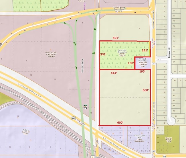
922 Plymouth Sorrento Rd
Orlando-Kissimmee-Sanford, FL
Plymouth
06-2128-7172-08-040
MAP OF PLYMOUTH B/17 LOT 4 (LESS S 150 FT OF E 200 FT) & (LE SS R/W ON E PER DB 385/509) & (LESS PT TAKEN FOR R/W ON E PE R 9852/7723) BLK H
Storebuilding
Orange
X
Florida
12095C0110H
4
2024
3.88 AC
2025
NW Orange Outlying
017902
Orlando
65,714 SF
DEMOGRAPHICS near 922 Plymouth Sorrento Rd
1 Mile
3 Mile
5 Mile
2024 Total Population
3,095
35,811
74,752
2029 Population
3,192
37,190
77,628
Pop Growth 2024-2029
+ 3.13%
+ 3.85%
+ 3.85%
Average Age
41
41
40
2024 Total Households
1,110
12,225
25,320
HH Growth 2024-2029
+ 3.06%
+ 3.84%
+ 3.82%
Median Household Inc
$52,204
$79,393
$75,680
Avg Household Size
2.80
2.90
2.90
2024 Avg HH Vehicles
2.00
2.00
2.00
Median Home Value
$317,419
$309,065
$307,940
Median Year Built
1994
2000
1997
Nearby Places
- Restaurants
- Banks
- Shops
- Fitness
- Groceries
PUBLIC TRANSPORTATION
AIRPORT
Orlando Sanford International
DRIVE
WALK
Distance
Orlando Sanford International
45 min
31.5 mi
Orlando International
DRIVE
WALK
Distance
Orlando International
43 min
33.2 mi
Freight Ports
Port Canaveral
DRIVE
WALK
Distance
Port Canaveral
91 min
75.8 mi
Nearby Properties
Address
Land Use
TOTAL SIZE
Lot Size
Zoning
Address
Land Use
TOTAL SIZE
Lot Size
Zoning
1,245,060 SF
90.98 AC
PD
Address
Land Use
TOTAL SIZE
Lot Size
Zoning
1,208,378 SF
57.24 AC
PD
Address
Land Use
TOTAL SIZE
Lot Size
Zoning
722,019 SF
35.47 AC
PD
Address
Land Use
TOTAL SIZE
Lot Size
Zoning
792,152 SF
53.04 AC
O
Address
Land Use
TOTAL SIZE
Lot Size
Zoning
588,076 SF
38.89 AC
PD
Address
Land Use
TOTAL SIZE
Lot Size
Zoning
537,895 SF
55.19 AC
I-L
Address
Land Use
TOTAL SIZE
Lot Size
Zoning
343,587 SF
9.67 AC
MU-ES-GT
Address
Land Use
TOTAL SIZE
Lot Size
Zoning
299,743 SF
PD
Address
Land Use
TOTAL SIZE
Lot Size
Zoning
323,161 SF
43.61 AC
PD
Address
Land Use
TOTAL SIZE
Lot Size
Zoning
347,706 SF
40.19 AC
PD
Address
Land Use
TOTAL SIZE
Lot Size
Zoning
293,305 SF
21.60 AC
PD
Address
Land Use
TOTAL SIZE
Lot Size
Zoning
278,981 SF
51.18 AC
I-L
Address
Land Use
TOTAL SIZE
Lot Size
Zoning
589,600 SF
19.60 AC
I-L
Address
Land Use
TOTAL SIZE
Lot Size
Zoning
313,324 SF
32.44 AC
PR
Address
Land Use
TOTAL SIZE
Lot Size
Zoning
255,880 SF
15.73 AC
PD
Address
Land Use
TOTAL SIZE
Lot Size
Zoning
133,960 SF
17.21 AC
PD
Address
Land Use
TOTAL SIZE
Lot Size
Zoning
805,668 SF
19.32 AC
I-L
Address
Land Use
TOTAL SIZE
Lot Size
Zoning
275,446 SF
12.81 AC
I-L
Address
Land Use
TOTAL SIZE
Lot Size
Zoning
193,525 SF
10.07 AC
D-APK-I-L
Address
Land Use
TOTAL SIZE
Lot Size
Zoning
503,677 SF
27.63 AC
I-L
Address
Land Use
TOTAL SIZE
Lot Size
Zoning
75.90 AC
MU-KPI
Address
Land Use
TOTAL SIZE
Lot Size
Zoning
3,688 SF
71.90 AC
MU-KPI
Address
Land Use
TOTAL SIZE
Lot Size
Zoning
144,713 SF
10.10 AC
I-L
Address
Land Use
TOTAL SIZE
Lot Size
Zoning
121,241 SF
4.66 AC
I-L
Address
Land Use
TOTAL SIZE
Lot Size
Zoning
185,772 SF
16.70 AC
O
Address
Land Use
TOTAL SIZE
Lot Size
Zoning
178,662 SF
17.71 AC
PUD
Address
Land Use
TOTAL SIZE
Lot Size
Zoning
78.33 AC
PD
Address
Land Use
TOTAL SIZE
Lot Size
Zoning
49 AC
D-APK-MU-K
Address
Land Use
TOTAL SIZE
Lot Size
Zoning
175,687 SF
15.13 AC
O
Address
Land Use
TOTAL SIZE
Lot Size
Zoning
47 AC
D-APK-MU-K
The World's #1 Commercial Real Estate Marketplace
Connect with us
© 2025 CoStar Group
The information above has been obtained from sources believed reliable. While we do not doubt its accuracy we have not verified it and make no guarantee, warranty or representation about it. It is your responsibility to independently confirm its accuracy and completeness. Any projections, opinions, assumptions, or estimates used are for example only and do not represent the current or future performance of the property. The value of this transaction to you depends on tax and other factors which should be evaluated by your tax, financial, and legal advisors. You and your advisors should conduct a careful, independent investigation of the property to determine to your satisfaction the suitability of the property for your needs.