Property Record
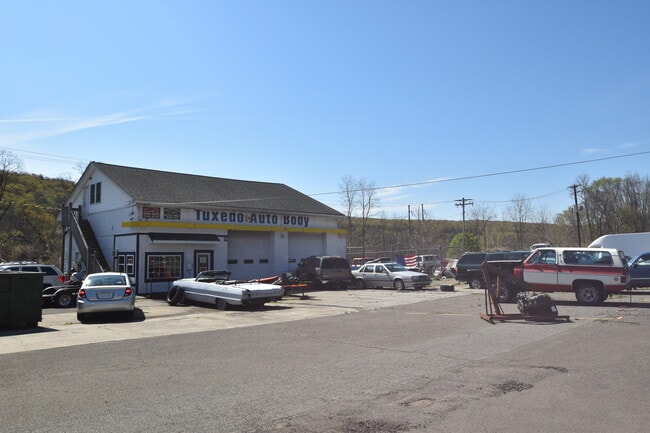
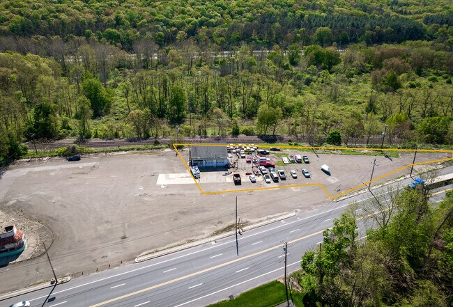
922 Route 17, Southfields, NY 10975

Property Detail
922 Route 17
Kiryas Joel-Poughkeepsie-Newburgh, NY
ORANGE
335089-005-000-0003-017.100-0000
New York
Autorepair
17.10
B and X Area of moderate flood hazard, usually the area between the limits of the 100-year and 500-year floods.
1.10 AC
2024
Monroe
2024
Northern New Jersey
014900
NEARBY LISTINGS FOR SALE OR LEASE
-
-
View all Southfields listings for lease on LoopNet.com
DEMOGRAPHICS near 922 Route 17
1 mile
3 mile
5 mile
2025 Total Population
406
1,860
14,354
2030 Population
415
1,937
14,702
Pop Growth 2025-2030
+ 2.22%
+ 4.14%
+ 2.42%
Average Age
43
45
42
2025 Total Households
141
684
4,890
HH Growth 2025-2030
+ 2.13%
+ 4.53%
+ 2.66%
Median Household Inc
$110,483
$128,385
$132,237
Avg Household Size
2.60
2.50
2.80
2025 Avg HH Vehicles
2.00
2.00
2.00
Median Home Value
$565,574
$750,000
$550,619
Median Year Built
1962
1956
1975
Nearby Places
Map Layers
Map Styles
 Street
 Aerial
Transit
 Traffic
 Biking
Places
Listings with unknown addresses are not visible on the map
- Restaurants
- Banks
- Shops
- Fitness
- Groceries
PUBLIC TRANSPORTATION
COMMUTER RAIL
Tuxedo (Bergen County/Port Jervis Line - NJ Transit Commuter Rail (NJ Transit), Main/Port Jervis Line - NJ Transit Commuter Rail (NJ Transit))
Drive
Walk
Distance
Tuxedo (Bergen County/Port Jervis Line - NJ Transit Commuter Rail (NJ Transit), Main/Port Jervis Line - NJ Transit Commuter Rail (NJ Transit))
8 min
3.5 mi
Harriman (Bergen County/Port Jervis Line - NJ Transit Commuter Rail (NJ Transit), Main/Port Jervis Line - NJ Transit Commuter Rail (NJ Transit))
Drive
Walk
Distance
Harriman (Bergen County/Port Jervis Line - NJ Transit Commuter Rail (NJ Transit), Main/Port Jervis Line - NJ Transit Commuter Rail (NJ Transit))
8 min
4.5 mi
AIRPORT
New York Stewart International
Drive
Walk
Distance
New York Stewart International
40 min
27.1 mi
Westchester County
Drive
Walk
Distance
Westchester County
60 min
40.6 mi
Freight Ports
Port Newark Container Terminal
Drive
Walk
Distance
Port Newark Container Terminal
70 min
45.9 mi
SALE & LEASE HISTORY
LISTING DATE
SALE/LEASE

May 28, 2020
For Sale
Dec 14, 2021
For Lease
Dec 03, 2021
For Sale
Nearby Properties
Address
Land Use
TOTAL SIZE
Lot Size
Zoning
Address
Land Use
TOTAL SIZE
Lot Size
Zoning
3,734.70 AC
Address
Land Use
TOTAL SIZE
Lot Size
Zoning
2,210.70 AC
Address
Land Use
TOTAL SIZE
Lot Size
Zoning
1,490.50 AC
Address
Land Use
TOTAL SIZE
Lot Size
Zoning
911.30 AC
Address
Land Use
TOTAL SIZE
Lot Size
Zoning
1,248.30 AC
Address
Land Use
TOTAL SIZE
Lot Size
Zoning
25 AC
911
Address
Land Use
TOTAL SIZE
Lot Size
Zoning
Address
Land Use
TOTAL SIZE
Lot Size
Zoning
42.10 AC
911
Address
Land Use
TOTAL SIZE
Lot Size
Zoning
3.80 AC
Address
Land Use
TOTAL SIZE
Lot Size
Zoning
Address
Land Use
TOTAL SIZE
Lot Size
Zoning
290 AC
Address
Land Use
TOTAL SIZE
Lot Size
Zoning
503.80 AC
Address
Land Use
TOTAL SIZE
Lot Size
Zoning
1,869 SF
268.90 AC
205
Address
Land Use
TOTAL SIZE
Lot Size
Zoning
17,990 SF
0.54 AC
RM1
Address
Land Use
TOTAL SIZE
Lot Size
Zoning
6.20 AC
911
Address
Land Use
TOTAL SIZE
Lot Size
Zoning
508.40 AC
Address
Land Use
TOTAL SIZE
Lot Size
Zoning
12.60 AC
Address
Land Use
TOTAL SIZE
Lot Size
Zoning
384 AC
401
Address
Land Use
TOTAL SIZE
Lot Size
Zoning
389.03 AC
Address
Land Use
TOTAL SIZE
Lot Size
Zoning
3.23 AC
911
Address
Land Use
TOTAL SIZE
Lot Size
Zoning
299.78 AC
Address
Land Use
TOTAL SIZE
Lot Size
Zoning
50.50 AC
Address
Land Use
TOTAL SIZE
Lot Size
Zoning
31.86 AC
911
Address
Land Use
TOTAL SIZE
Lot Size
Zoning
2,655 SF
12.10 AC
R3A
Address
Land Use
TOTAL SIZE
Lot Size
Zoning
247.26 AC
Address
Land Use
TOTAL SIZE
Lot Size
Zoning
1,648 SF
6.30 AC
Address
Land Use
TOTAL SIZE
Lot Size
Zoning
960 SF
74.80 AC
R3A
Address
Land Use
TOTAL SIZE
Lot Size
Zoning
64.49 AC
Address
Land Use
TOTAL SIZE
Lot Size
Zoning
6.20 AC
Address
Land Use
TOTAL SIZE
Lot Size
Zoning
6.20 AC
911
The World's #1 Commercial Real Estate Marketplace
Connect with us
© 2026 CoStar Group
The information above has been obtained from sources believed reliable. While we do not doubt its accuracy we have not verified it and make no guarantee, warranty or representation about it. It is your responsibility to independently confirm its accuracy and completeness. Any projections, opinions, assumptions, or estimates used are for example only and do not represent the current or future performance of the property. The value of this transaction to you depends on tax and other factors which should be evaluated by your tax, financial, and legal advisors. You and your advisors should conduct a careful, independent investigation of the property to determine to your satisfaction the suitability of the property for your needs.