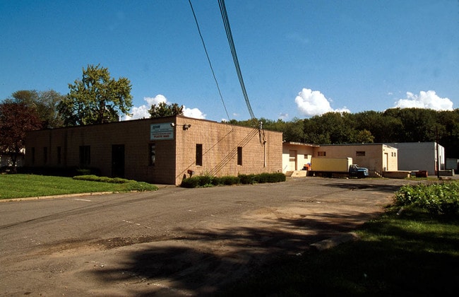
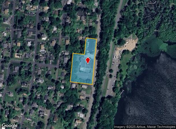
Property Record
922 S Route 9W, Congers, NY 10920
NEARBY LISTINGS FOR SALE OR LEASE
Property Detail
922 S Route 9W
New York-Jersey City-White Plains, NY-NJ
Boston Improv Co Sec
392089-044-020-0004-013-000-0000
140-B-6
Restaurantbuilding
Rockland
X
New York
36087C0118G
13.0
2023
2 AC
2024
Rockland County
010902
Northern New Jersey
26,859 SF
DEMOGRAPHICS near 922 S Route 9W
1 Mile
3 Mile
5 Mile
2024 Total Population
5,625
28,714
124,844
2029 Population
5,568
28,554
123,193
Pop Growth 2024-2029
(1.01%)
(0.56%)
(1.32%)
Average Age
43
43
42
2024 Total Households
1,925
10,066
43,675
HH Growth 2024-2029
(1.04%)
(0.55%)
(1.39%)
Median Household Inc
$122,441
$123,063
$115,036
Avg Household Size
2.80
2.80
2.80
2024 Avg HH Vehicles
2.00
2.00
2.00
Median Home Value
$456,085
$524,370
$547,278
Median Year Built
1974
1970
1965
Nearby Places
- Restaurants
- Banks
- Shops
- Fitness
- Groceries
PUBLIC TRANSPORTATION
AIRPORT
Westchester County
DRIVE
WALK
Distance
Westchester County
32 min
22.8 mi
New York Stewart International
DRIVE
WALK
Distance
New York Stewart International
51 min
34.7 mi
LaGuardia
DRIVE
WALK
Distance
LaGuardia
52 min
35.5 mi
Freight Ports
NY - Red Hook Container Terminal
DRIVE
WALK
Distance
NY - Red Hook Container Terminal
64 min
43.7 mi
Nearby Properties
Address
Land Use
TOTAL SIZE
Lot Size
Zoning
Address
Land Use
TOTAL SIZE
Lot Size
Zoning
247,711 SF
37.26 AC
Address
Land Use
TOTAL SIZE
Lot Size
Zoning
201.67 AC
Address
Land Use
TOTAL SIZE
Lot Size
Zoning
Address
Land Use
TOTAL SIZE
Lot Size
Zoning
Address
Land Use
TOTAL SIZE
Lot Size
Zoning
68,910 SF
6.90 AC
02 - SINGL
Address
Land Use
TOTAL SIZE
Lot Size
Zoning
Address
Land Use
TOTAL SIZE
Lot Size
Zoning
100,800 SF
13.40 AC
02 - SINGL
Address
Land Use
TOTAL SIZE
Lot Size
Zoning
130,930 SF
11 AC
Address
Land Use
TOTAL SIZE
Lot Size
Zoning
248,709 SF
15.30 AC
Address
Land Use
TOTAL SIZE
Lot Size
Zoning
99,725 SF
17.78 AC
03 - MULTI
Address
Land Use
TOTAL SIZE
Lot Size
Zoning
58,786 SF
7.90 AC
Address
Land Use
TOTAL SIZE
Lot Size
Zoning
40,194 SF
14 AC
Address
Land Use
TOTAL SIZE
Lot Size
Zoning
35,921 SF
6.10 AC
02 - SINGL
Address
Land Use
TOTAL SIZE
Lot Size
Zoning
26,698 SF
7.75 AC
Address
Land Use
TOTAL SIZE
Lot Size
Zoning
38,700 SF
21.45 AC
Address
Land Use
TOTAL SIZE
Lot Size
Zoning
51,445 SF
12.70 AC
Address
Land Use
TOTAL SIZE
Lot Size
Zoning
111,550 SF
9.29 AC
LI
Address
Land Use
TOTAL SIZE
Lot Size
Zoning
43,525 SF
14.30 AC
02 - SINGL
Address
Land Use
TOTAL SIZE
Lot Size
Zoning
81,780 SF
7.52 AC
Address
Land Use
TOTAL SIZE
Lot Size
Zoning
30,679 SF
39 AC
Address
Land Use
TOTAL SIZE
Lot Size
Zoning
92,695 SF
5.42 AC
05
Address
Land Use
TOTAL SIZE
Lot Size
Zoning
72,080 SF
6.23 AC
Address
Land Use
TOTAL SIZE
Lot Size
Zoning
33,489 SF
47.55 AC
Address
Land Use
TOTAL SIZE
Lot Size
Zoning
61,100 SF
5.20 AC
02 - SINGL
Address
Land Use
TOTAL SIZE
Lot Size
Zoning
72,380 SF
2.95 AC
Address
Land Use
TOTAL SIZE
Lot Size
Zoning
37,560 SF
7.60 AC
Address
Land Use
TOTAL SIZE
Lot Size
Zoning
73,027 SF
35.69 AC
Address
Land Use
TOTAL SIZE
Lot Size
Zoning
42,055 SF
11 AC
Address
Land Use
TOTAL SIZE
Lot Size
Zoning
58,444 SF
3.50 AC
R1
Address
Land Use
TOTAL SIZE
Lot Size
Zoning
76,093 SF
4.80 AC
LI
The World's #1 Commercial Real Estate Marketplace
Connect with us
© 2025 CoStar Group
The information above has been obtained from sources believed reliable. While we do not doubt its accuracy we have not verified it and make no guarantee, warranty or representation about it. It is your responsibility to independently confirm its accuracy and completeness. Any projections, opinions, assumptions, or estimates used are for example only and do not represent the current or future performance of the property. The value of this transaction to you depends on tax and other factors which should be evaluated by your tax, financial, and legal advisors. You and your advisors should conduct a careful, independent investigation of the property to determine to your satisfaction the suitability of the property for your needs.