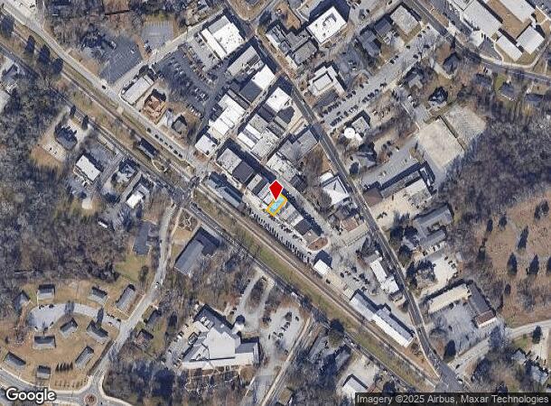
Property Record
923 Commercial St Ne, Conyers, GA 30012
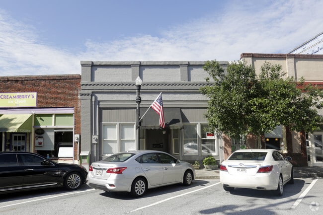
This Property Is For Sale
NEARBY LISTINGS FOR SALE OR LEASE
Property Detail
923 Commercial St Ne
Atlanta-Sandy Springs-Roswell, GA
Commercial
C19-0-03-010A
S/SIDE COMMERCIAL ST
Storesoffices
Rockdale
X
Georgia
13247C0092D
295
2025
0.05 AC
2025
Lithonia/Conyers
060310
Atlanta
2,015 SF
DEMOGRAPHICS near 923 Commercial St Ne
1 Mile
3 Mile
5 Mile
2024 Total Population
5,576
36,220
81,154
2029 Population
5,858
37,514
83,925
Pop Growth 2024-2029
+ 5.06%
+ 3.57%
+ 3.41%
Average Age
39
38
39
2024 Total Households
2,092
13,142
29,016
HH Growth 2024-2029
+ 5.16%
+ 3.57%
+ 3.38%
Median Household Inc
$50,492
$56,619
$67,989
Avg Household Size
2.50
2.70
2.70
2024 Avg HH Vehicles
1.00
2.00
2.00
Median Home Value
$189,264
$187,928
$211,171
Median Year Built
1968
1987
1989
Nearby Places
Map Layers
Map Styles
 Street
 Aerial
- Restaurants
- Banks
- Shops
- Fitness
- Groceries
PUBLIC TRANSPORTATION
AIRPORT
Hartsfield - Jackson Atlanta International
DRIVE
WALK
Distance
Hartsfield - Jackson Atlanta International
39 min
28.0 mi
Nearby Properties
Address
Land Use
TOTAL SIZE
Lot Size
Zoning
Address
Land Use
TOTAL SIZE
Lot Size
Zoning
6,092 SF
37.63 AC
RM
Address
Land Use
TOTAL SIZE
Lot Size
Zoning
5,212 SF
21.33 AC
GV-UV
Address
Land Use
TOTAL SIZE
Lot Size
Zoning
2,782 SF
29.51 AC
R3/C
Address
Land Use
TOTAL SIZE
Lot Size
Zoning
22,362 SF
28.90 AC
MXD
Address
Land Use
TOTAL SIZE
Lot Size
Zoning
447,440 SF
47.74 AC
ID
Address
Land Use
TOTAL SIZE
Lot Size
Zoning
458,448 SF
12.98 AC
OI
Address
Land Use
TOTAL SIZE
Lot Size
Zoning
140,292 SF
23.74 AC
HSB
Address
Land Use
TOTAL SIZE
Lot Size
Zoning
454,480 SF
52.17 AC
ID
Address
Land Use
TOTAL SIZE
Lot Size
Zoning
28,024 SF
11.24 AC
R1
Address
Land Use
TOTAL SIZE
Lot Size
Zoning
3,046 SF
32.01 AC
RM
Address
Land Use
TOTAL SIZE
Lot Size
Zoning
3,256 SF
22.05 AC
RM
Address
Land Use
TOTAL SIZE
Lot Size
Zoning
55,928 SF
14.63 AC
BN
Address
Land Use
TOTAL SIZE
Lot Size
Zoning
20,964 SF
25.29 AC
R3/C
Address
Land Use
TOTAL SIZE
Lot Size
Zoning
165,171 SF
49.79 AC
BG/ID
Address
Land Use
TOTAL SIZE
Lot Size
Zoning
3,066 SF
22.44 AC
R3/R1
Address
Land Use
TOTAL SIZE
Lot Size
Zoning
8,268 SF
46.94 AC
R3
Address
Land Use
TOTAL SIZE
Lot Size
Zoning
3,648 SF
26.50 AC
R3/R1
Address
Land Use
TOTAL SIZE
Lot Size
Zoning
177,123 SF
9.63 AC
MXD/CID/MU
Address
Land Use
TOTAL SIZE
Lot Size
Zoning
210,380 SF
15.86 AC
ID
Address
Land Use
TOTAL SIZE
Lot Size
Zoning
417,378 SF
31.95 AC
M1
Address
Land Use
TOTAL SIZE
Lot Size
Zoning
77,600 SF
9 AC
GVUV
Address
Land Use
TOTAL SIZE
Lot Size
Zoning
3,888 SF
21.05 AC
RM/C
Address
Land Use
TOTAL SIZE
Lot Size
Zoning
17,800 SF
11.36 AC
RM/C
Address
Land Use
TOTAL SIZE
Lot Size
Zoning
180,890 SF
45.15 AC
R1
Address
Land Use
TOTAL SIZE
Lot Size
Zoning
205,716 SF
22.88 AC
ID
Address
Land Use
TOTAL SIZE
Lot Size
Zoning
140,850 SF
19.09 AC
ID
Address
Land Use
TOTAL SIZE
Lot Size
Zoning
6,561 SF
7.49 AC
GVUV
Address
Land Use
TOTAL SIZE
Lot Size
Zoning
472,620 SF
55.20 AC
RS10
Address
Land Use
TOTAL SIZE
Lot Size
Zoning
200,943 SF
18.32 AC
M1
Address
Land Use
TOTAL SIZE
Lot Size
Zoning
201,089 SF
13.40 AC
ID
The World's #1 Commercial Real Estate Marketplace
Connect with us
© 2026 CoStar Group
The information above has been obtained from sources believed reliable. While we do not doubt its accuracy we have not verified it and make no guarantee, warranty or representation about it. It is your responsibility to independently confirm its accuracy and completeness. Any projections, opinions, assumptions, or estimates used are for example only and do not represent the current or future performance of the property. The value of this transaction to you depends on tax and other factors which should be evaluated by your tax, financial, and legal advisors. You and your advisors should conduct a careful, independent investigation of the property to determine to your satisfaction the suitability of the property for your needs.