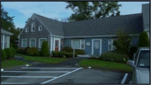
Property Record
923 Route 6A, Yarmouth Port, MA 02675
NEARBY LISTINGS FOR SALE OR LEASE
Property Detail
923 Route 6A
Officecondo
Barnstable
X
Massachusetts
25001C0579J
ccc
2025
Cape Cod
2025
Other Market Areas
011802
Barnstable Town, MA
894 SF
YARM-000143-000111-000000-C000000
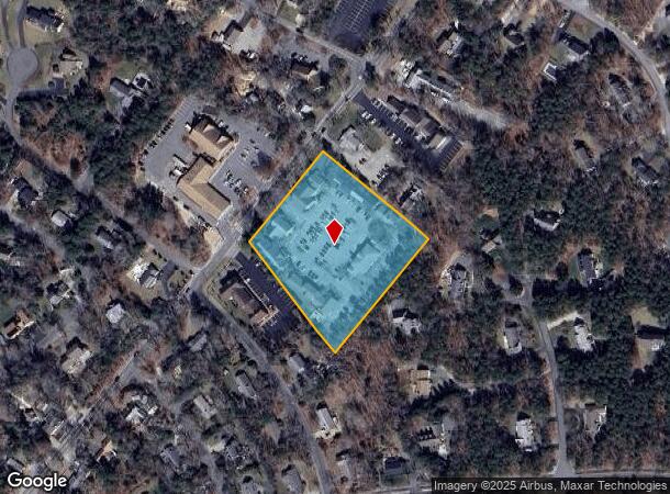
DEMOGRAPHICS near 923 Route 6A
1 Mile
3 Mile
5 Mile
2024 Total Population
3,274
20,664
42,265
2029 Population
3,348
21,220
43,684
Pop Growth 2024-2029
+ 2.26%
+ 2.69%
+ 3.36%
Average Age
58
53
51
2024 Total Households
1,653
9,583
19,705
HH Growth 2024-2029
+ 2.12%
+ 2.47%
+ 3.21%
Median Household Inc
$101,397
$89,843
$79,946
Avg Household Size
2.00
2.10
2.10
2024 Avg HH Vehicles
2.00
2.00
2.00
Median Home Value
$472,308
$456,569
$459,036
Median Year Built
1982
1975
1973
Nearby Places
Map Layers
Map Styles
 Street
 Aerial
- Restaurants
- Banks
- Shops
- Fitness
- Groceries
PUBLIC TRANSPORTATION
COMMUTER RAIL
Hyannis (CapeFLYER - Cape Cod Regional Transit Authority)
DRIVE
WALK
Distance
Hyannis (CapeFLYER - Cape Cod Regional Transit Authority)
12 min
6.6 mi
Freight Ports
Port of New Bedford Harbor
DRIVE
WALK
Distance
Port of New Bedford Harbor
75 min
53.3 mi
SALE & LEASE HISTORY
LISTING DATE
SALE/LEASE

Sep 25, 2016
For Lease
Nearby Properties
Address
Land Use
TOTAL SIZE
Lot Size
Zoning
Address
Land Use
TOTAL SIZE
Lot Size
Zoning
221,710 SF
67.02 AC
Address
Land Use
TOTAL SIZE
Lot Size
Zoning
11,698 SF
34.50 AC
Address
Land Use
TOTAL SIZE
Lot Size
Zoning
138,804 SF
15.94 AC
Address
Land Use
TOTAL SIZE
Lot Size
Zoning
1,228 SF
10.54 AC
Address
Land Use
TOTAL SIZE
Lot Size
Zoning
34.40 AC
Address
Land Use
TOTAL SIZE
Lot Size
Zoning
4,800 SF
414.61 AC
Address
Land Use
TOTAL SIZE
Lot Size
Zoning
5.11 AC
R-60
Address
Land Use
TOTAL SIZE
Lot Size
Zoning
2,560 SF
100.38 AC
Address
Land Use
TOTAL SIZE
Lot Size
Zoning
5.42 AC
Address
Land Use
TOTAL SIZE
Lot Size
Zoning
14.54 AC
Address
Land Use
TOTAL SIZE
Lot Size
Zoning
163.08 AC
Address
Land Use
TOTAL SIZE
Lot Size
Zoning
Address
Land Use
TOTAL SIZE
Lot Size
Zoning
38,518 SF
5.09 AC
Address
Land Use
TOTAL SIZE
Lot Size
Zoning
59,756 SF
9.56 AC
Address
Land Use
TOTAL SIZE
Lot Size
Zoning
18.49 AC
Address
Land Use
TOTAL SIZE
Lot Size
Zoning
6.12 AC
R-60
Address
Land Use
TOTAL SIZE
Lot Size
Zoning
44,504 SF
5.33 AC
Address
Land Use
TOTAL SIZE
Lot Size
Zoning
Address
Land Use
TOTAL SIZE
Lot Size
Zoning
0.69 AC
R-40
Address
Land Use
TOTAL SIZE
Lot Size
Zoning
0.95 AC
Address
Land Use
TOTAL SIZE
Lot Size
Zoning
1,636 SF
10.60 AC
Address
Land Use
TOTAL SIZE
Lot Size
Zoning
162.60 AC
Address
Land Use
TOTAL SIZE
Lot Size
Zoning
Address
Land Use
TOTAL SIZE
Lot Size
Zoning
10,688 SF
3.65 AC
Address
Land Use
TOTAL SIZE
Lot Size
Zoning
1,938 SF
5.50 AC
Address
Land Use
TOTAL SIZE
Lot Size
Zoning
624 SF
193.54 AC
Address
Land Use
TOTAL SIZE
Lot Size
Zoning
Address
Land Use
TOTAL SIZE
Lot Size
Zoning
72,240 SF
Address
Land Use
TOTAL SIZE
Lot Size
Zoning
0.65 AC
Address
Land Use
TOTAL SIZE
Lot Size
Zoning
8,296 SF
7.51 AC
The World's #1 Commercial Real Estate Marketplace
Connect with us
© 2025 CoStar Group
The information above has been obtained from sources believed reliable. While we do not doubt its accuracy we have not verified it and make no guarantee, warranty or representation about it. It is your responsibility to independently confirm its accuracy and completeness. Any projections, opinions, assumptions, or estimates used are for example only and do not represent the current or future performance of the property. The value of this transaction to you depends on tax and other factors which should be evaluated by your tax, financial, and legal advisors. You and your advisors should conduct a careful, independent investigation of the property to determine to your satisfaction the suitability of the property for your needs.