Property Record
Us Highway 27 Dr, Minneola, FL 34715

NEARBY LISTINGS FOR SALE OR LEASE
Property Detail
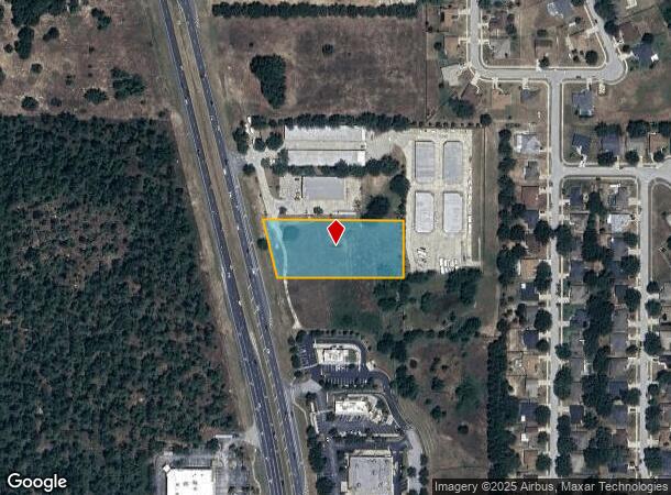
Us Highway 27 Dr
Orlando-Kissimmee-Sanford, FL
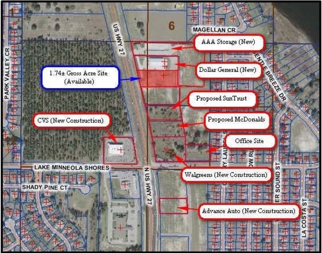
Aaa Storage Commercial Subdivision
07-22-26-0350-000-00200
AAA STORAGE COMMERCIAL SUBDIVISION PB 61 PG 11-12 LOT 2 ORB 3497 PG 543
Commercialacreage
Lake
X
Florida
12069C0560E
2
2024
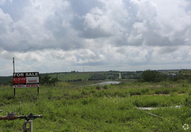
1.72 AC
2026
Lake County
031309
Orlando
DEMOGRAPHICS near Us Highway 27 Dr
1 Mile
3 Mile
5 Mile
2024 Total Population
5,696
38,099
76,679
2029 Population
6,736
44,856
89,990
Pop Growth 2024-2029
+ 18.26%
+ 17.74%
+ 17.36%
Average Age
38
40
41
2024 Total Households
1,895
13,663
27,775
HH Growth 2024-2029
+ 17.89%
+ 17.46%
+ 17.11%
Median Household Inc
$88,141
$82,229
$81,457
Avg Household Size
3.00
2.70
2.70
2024 Avg HH Vehicles
2.00
2.00
2.00
Median Home Value
$324,331
$326,720
$321,245
Median Year Built
2006
2004
2004
Nearby Places
- Restaurants
- Banks
- Shops
- Fitness
- Groceries
PUBLIC TRANSPORTATION
AIRPORT
Orlando International
DRIVE
WALK
Distance
Orlando International
48 min
35.6 mi
Freight Ports
Port of Tampa Bay
DRIVE
WALK
Distance
Port of Tampa Bay
104 min
78.4 mi
SALE & LEASE HISTORY
LISTING DATE
SALE/LEASE

Sep 24, 2016
For Sale
Nearby Properties
Address
Land Use
TOTAL SIZE
Lot Size
Zoning
Address
Land Use
TOTAL SIZE
Lot Size
Zoning
403,970 SF
30.99 AC
PUD
Address
Land Use
TOTAL SIZE
Lot Size
Zoning
337,218 SF
16.38 AC
Address
Land Use
TOTAL SIZE
Lot Size
Zoning
2,000 SF
63.78 AC
Address
Land Use
TOTAL SIZE
Lot Size
Zoning
142,824 SF
9.90 AC
C2
Address
Land Use
TOTAL SIZE
Lot Size
Zoning
203,762 SF
18.28 AC
R1
Address
Land Use
TOTAL SIZE
Lot Size
Zoning
80,774 SF
6.61 AC
Address
Land Use
TOTAL SIZE
Lot Size
Zoning
128,174 SF
9.88 AC
B1
Address
Land Use
TOTAL SIZE
Lot Size
Zoning
80,546 SF
6.75 AC
B1
Address
Land Use
TOTAL SIZE
Lot Size
Zoning
62,415 SF
10.19 AC
Address
Land Use
TOTAL SIZE
Lot Size
Zoning
74,375 SF
6.69 AC
Address
Land Use
TOTAL SIZE
Lot Size
Zoning
123,387 SF
47.51 AC
R3
Address
Land Use
TOTAL SIZE
Lot Size
Zoning
55,754 SF
9.14 AC
R2
Address
Land Use
TOTAL SIZE
Lot Size
Zoning
2,000 SF
19.45 AC
Address
Land Use
TOTAL SIZE
Lot Size
Zoning
30,926 SF
0.38 AC
Address
Land Use
TOTAL SIZE
Lot Size
Zoning
81,188 SF
7.70 AC
C2
Address
Land Use
TOTAL SIZE
Lot Size
Zoning
73,040 SF
4.89 AC
I1
Address
Land Use
TOTAL SIZE
Lot Size
Zoning
40,798 SF
7.51 AC
P
Address
Land Use
TOTAL SIZE
Lot Size
Zoning
102,584 SF
9.21 AC
R3
Address
Land Use
TOTAL SIZE
Lot Size
Zoning
24,910 SF
3.44 AC
CBD
Address
Land Use
TOTAL SIZE
Lot Size
Zoning
29,892 SF
2.46 AC
R3
Address
Land Use
TOTAL SIZE
Lot Size
Zoning
28,836 SF
2.34 AC
Address
Land Use
TOTAL SIZE
Lot Size
Zoning
35,042 SF
2.59 AC
CBD
Address
Land Use
TOTAL SIZE
Lot Size
Zoning
28,560 SF
9.89 AC
PUD
Address
Land Use
TOTAL SIZE
Lot Size
Zoning
30.07 AC
Address
Land Use
TOTAL SIZE
Lot Size
Zoning
14,106 SF
1.69 AC
RSF2
Address
Land Use
TOTAL SIZE
Lot Size
Zoning
2,000 SF
17.63 AC
P
Address
Land Use
TOTAL SIZE
Lot Size
Zoning
19,498 SF
0.69 AC
CBD
Address
Land Use
TOTAL SIZE
Lot Size
Zoning
2,000 SF
20.63 AC
R1
Address
Land Use
TOTAL SIZE
Lot Size
Zoning
31,018 SF
2.88 AC
B1
Address
Land Use
TOTAL SIZE
Lot Size
Zoning
51,272 SF
4.91 AC
C2
The World's #1 Commercial Real Estate Marketplace
Connect with us
© 2025 CoStar Group
The information above has been obtained from sources believed reliable. While we do not doubt its accuracy we have not verified it and make no guarantee, warranty or representation about it. It is your responsibility to independently confirm its accuracy and completeness. Any projections, opinions, assumptions, or estimates used are for example only and do not represent the current or future performance of the property. The value of this transaction to you depends on tax and other factors which should be evaluated by your tax, financial, and legal advisors. You and your advisors should conduct a careful, independent investigation of the property to determine to your satisfaction the suitability of the property for your needs.