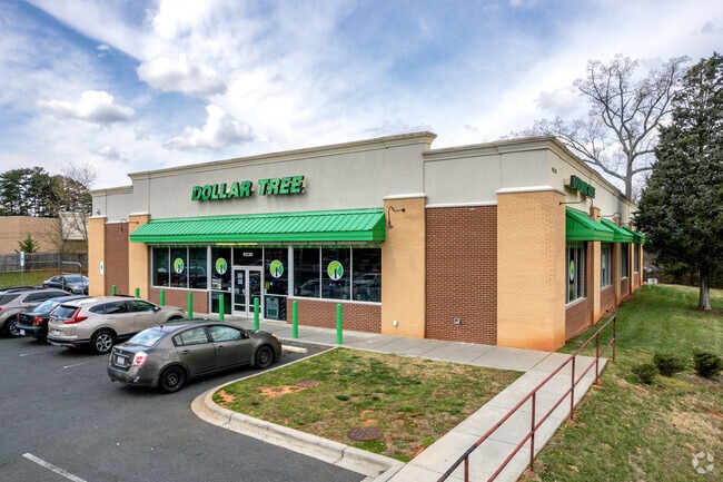
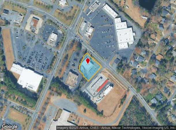
Property Record
9230 Lawyers Rd, Mint Hill, NC 28227

NEARBY LISTINGS FOR SALE OR LEASE
-
-
View all Mint Hill listings for sale on LoopNet.com
Property Detail
9230 Lawyers Rd
Charlotte-Concord-Gastonia, NC-SC
B-2
135-221-32
LB-2 M56-205
Commercialnec
Mecklenburg
X
North Carolina
3710459200K
b-2
0
0.95 AC
2025
East
005721
Charlotte
8,938 SF
DEMOGRAPHICS near 9230 Lawyers Rd
1 Mile
3 Mile
5 Mile
2024 Total Population
6,613
66,474
177,053
2029 Population
6,884
70,017
187,094
Pop Growth 2024-2029
+ 4.10%
+ 5.33%
+ 5.67%
Average Age
39
38
38
2024 Total Households
2,337
24,031
67,051
HH Growth 2024-2029
+ 4.15%
+ 5.35%
+ 5.69%
Median Household Inc
$74,107
$61,812
$62,923
Avg Household Size
2.80
2.70
2.60
2024 Avg HH Vehicles
2.00
2.00
2.00
Median Home Value
$292,691
$261,289
$273,528
Median Year Built
1985
1986
1986
Nearby Places
Map Layers
Map Styles
 Street
 Aerial
- Restaurants
- Banks
- Shops
- Fitness
- Groceries
PUBLIC TRANSPORTATION
AIRPORT
Charlotte/Douglas International
DRIVE
WALK
Distance
Charlotte/Douglas International
32 min
17.6 mi
Concord-Padgett Regional
DRIVE
WALK
Distance
Concord-Padgett Regional
27 min
18.6 mi
Freight Ports
North Charleston Terminal
DRIVE
WALK
Distance
North Charleston Terminal
245 min
209.5 mi
Nearby Properties
Address
Land Use
TOTAL SIZE
Lot Size
Zoning
Address
Land Use
TOTAL SIZE
Lot Size
Zoning
539,702 SF
83.70 AC
I
Address
Land Use
TOTAL SIZE
Lot Size
Zoning
258,272 SF
22.10 AC
R9MFCD
Address
Land Use
TOTAL SIZE
Lot Size
Zoning
347,952 SF
28.37 AC
OACUD
Address
Land Use
TOTAL SIZE
Lot Size
Zoning
324,323 SF
31.39 AC
R17MF
Address
Land Use
TOTAL SIZE
Lot Size
Zoning
258,047 SF
64.31 AC
I-CUD
Address
Land Use
TOTAL SIZE
Lot Size
Zoning
270,091 SF
32.43 AC
R17MF
Address
Land Use
TOTAL SIZE
Lot Size
Zoning
208,846 SF
14.99 AC
R17MF
Address
Land Use
TOTAL SIZE
Lot Size
Zoning
205,701 SF
13.73 AC
OACUD
Address
Land Use
TOTAL SIZE
Lot Size
Zoning
249,650 SF
20.17 AC
R17MF
Address
Land Use
TOTAL SIZE
Lot Size
Zoning
207,338 SF
13.96 AC
R17MF
Address
Land Use
TOTAL SIZE
Lot Size
Zoning
166,800 SF
19.50 AC
R17MF
Address
Land Use
TOTAL SIZE
Lot Size
Zoning
220,767 SF
40.75 AC
R17MF
Address
Land Use
TOTAL SIZE
Lot Size
Zoning
148,190 SF
14.50 AC
R17MF
Address
Land Use
TOTAL SIZE
Lot Size
Zoning
155,648 SF
22.52 AC
R20MF
Address
Land Use
TOTAL SIZE
Lot Size
Zoning
137,719 SF
15.84 AC
O1
Address
Land Use
TOTAL SIZE
Lot Size
Zoning
108,006 SF
9.22 AC
R17MF
Address
Land Use
TOTAL SIZE
Lot Size
Zoning
96,071 SF
7.44 AC
Address
Land Use
TOTAL SIZE
Lot Size
Zoning
78,372 SF
14.08 AC
IGCUD
Address
Land Use
TOTAL SIZE
Lot Size
Zoning
112,203 SF
6.80 AC
R
Address
Land Use
TOTAL SIZE
Lot Size
Zoning
126,174 SF
12.13 AC
R9MFCD
Address
Land Use
TOTAL SIZE
Lot Size
Zoning
167,268 SF
17.44 AC
Address
Land Use
TOTAL SIZE
Lot Size
Zoning
96,660 SF
8.44 AC
BGCUD
Address
Land Use
TOTAL SIZE
Lot Size
Zoning
104,386 SF
13 AC
R4
Address
Land Use
TOTAL SIZE
Lot Size
Zoning
86,432 SF
20.01 AC
I
Address
Land Use
TOTAL SIZE
Lot Size
Zoning
64,732 SF
14.62 AC
R4
Address
Land Use
TOTAL SIZE
Lot Size
Zoning
40,890 SF
2.92 AC
O-A DO-B(C
Address
Land Use
TOTAL SIZE
Lot Size
Zoning
80,888 SF
8.20 AC
Address
Land Use
TOTAL SIZE
Lot Size
Zoning
77,438 SF
4.26 AC
BD
Address
Land Use
TOTAL SIZE
Lot Size
Zoning
104,915 SF
40.22 AC
INST
Address
Land Use
TOTAL SIZE
Lot Size
Zoning
67,080 SF
7.99 AC
The World's #1 Commercial Real Estate Marketplace
Connect with us
© 2025 CoStar Group
The information above has been obtained from sources believed reliable. While we do not doubt its accuracy we have not verified it and make no guarantee, warranty or representation about it. It is your responsibility to independently confirm its accuracy and completeness. Any projections, opinions, assumptions, or estimates used are for example only and do not represent the current or future performance of the property. The value of this transaction to you depends on tax and other factors which should be evaluated by your tax, financial, and legal advisors. You and your advisors should conduct a careful, independent investigation of the property to determine to your satisfaction the suitability of the property for your needs.