Property Record
9240 Sw Hull Ave, Arcadia, FL 34269
NEARBY LISTINGS FOR SALE OR LEASE
Property Detail
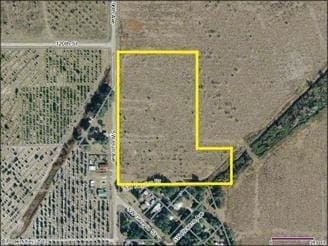
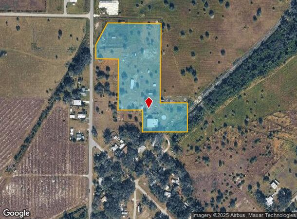
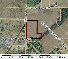
9240 Sw Hull Ave
18-39-24-0000-0060-0000
COMM AT NW COR OF NW1/4 OF NW1/4 OF SEC 18 TWP 39S RNG 24E TH S 00D2M34S W ALG W LI 561.00 FT TH S 89D43M16S E 111.31 FT TO POB TH CONT S 89D43M16S E 383.69 FT TH S 00D27M04S W 527.99 FT TH S 89D45M01S E 195.84 FT TH S 00D27M43S W 239.30 FT TH S 89D4
Dairyfarm
DeSoto
A
Florida
12027C0279D
6.54 AC
2024
Florida Central South Area
2024
Other Market Areas
010405
Arcadia, FL
DEMOGRAPHICS near 9240 Sw Hull Ave
1 Mile
3 Mile
5 Mile
2024 Total Population
341
1,804
3,679
2029 Population
369
1,932
4,050
Pop Growth 2024-2029
+ 8.21%
+ 7.10%
+ 10.08%
Average Age
41
50
51
2024 Total Households
121
755
1,579
HH Growth 2024-2029
+ 9.92%
+ 7.68%
+ 10.77%
Median Household Inc
$46,973
$47,662
$48,046
Avg Household Size
2.60
2.20
2.20
2024 Avg HH Vehicles
2.00
2.00
2.00
Median Home Value
$250,000
$128,611
$162,397
Median Year Built
1988
1990
1989
Nearby Places
Map Layers
Map Styles
 Street
 Aerial
- Restaurants
- Banks
- Shops
- Fitness
- Groceries
PUBLIC TRANSPORTATION
AIRPORT
Punta Gorda
DRIVE
WALK
Distance
Punta Gorda
23 min
14.8 mi
Freight Ports
Port Manatee
DRIVE
WALK
Distance
Port Manatee
97 min
75.1 mi
Nearby Properties
Address
Land Use
TOTAL SIZE
Lot Size
Zoning
Address
Land Use
TOTAL SIZE
Lot Size
Zoning
1,836 SF
17.80 AC
P/I
Address
Land Use
TOTAL SIZE
Lot Size
Zoning
8,044 SF
29.55 AC
TTRVC
Address
Land Use
TOTAL SIZE
Lot Size
Zoning
2,025 SF
28.05 AC
RVC
Address
Land Use
TOTAL SIZE
Lot Size
Zoning
3,248 SF
21.20 AC
MHP
Address
Land Use
TOTAL SIZE
Lot Size
Zoning
27,214 SF
7.92 AC
A-5
Address
Land Use
TOTAL SIZE
Lot Size
Zoning
4,800 SF
40.53 AC
PUD
Address
Land Use
TOTAL SIZE
Lot Size
Zoning
65.31 AC
P/I
Address
Land Use
TOTAL SIZE
Lot Size
Zoning
2,768 SF
285 AC
A-10
Address
Land Use
TOTAL SIZE
Lot Size
Zoning
8,838 SF
2.43 AC
RMF-6
Address
Land Use
TOTAL SIZE
Lot Size
Zoning
351 AC
A-10
Address
Land Use
TOTAL SIZE
Lot Size
Zoning
181 AC
A-5
Address
Land Use
TOTAL SIZE
Lot Size
Zoning
98.17 AC
A-10
Address
Land Use
TOTAL SIZE
Lot Size
Zoning
7,050 SF
4.49 AC
RSF-3
Address
Land Use
TOTAL SIZE
Lot Size
Zoning
10,151 SF
3.33 AC
A-5
Address
Land Use
TOTAL SIZE
Lot Size
Zoning
110.23 AC
A-10
Address
Land Use
TOTAL SIZE
Lot Size
Zoning
341 AC
A-10
Address
Land Use
TOTAL SIZE
Lot Size
Zoning
14,149 SF
12.20 AC
A-10
Address
Land Use
TOTAL SIZE
Lot Size
Zoning
169 AC
A-10
Address
Land Use
TOTAL SIZE
Lot Size
Zoning
5,119 SF
20.72 AC
A-10
Address
Land Use
TOTAL SIZE
Lot Size
Zoning
11,218 SF
58.49 AC
A-10
Address
Land Use
TOTAL SIZE
Lot Size
Zoning
64.50 AC
A-10
Address
Land Use
TOTAL SIZE
Lot Size
Zoning
160 AC
A-10
Address
Land Use
TOTAL SIZE
Lot Size
Zoning
21 AC
RMF-6
Address
Land Use
TOTAL SIZE
Lot Size
Zoning
5,274 SF
5 AC
RMF-M
Address
Land Use
TOTAL SIZE
Lot Size
Zoning
143 AC
A-10
Address
Land Use
TOTAL SIZE
Lot Size
Zoning
44.06 AC
RMF-6
Address
Land Use
TOTAL SIZE
Lot Size
Zoning
51 AC
RMF-6
Address
Land Use
TOTAL SIZE
Lot Size
Zoning
3,426 SF
6.87 AC
IL
Address
Land Use
TOTAL SIZE
Lot Size
Zoning
1,430 SF
186.36 AC
A-10
Address
Land Use
TOTAL SIZE
Lot Size
Zoning
76 AC
A-10
The World's #1 Commercial Real Estate Marketplace
Connect with us
© 2025 CoStar Group
The information above has been obtained from sources believed reliable. While we do not doubt its accuracy we have not verified it and make no guarantee, warranty or representation about it. It is your responsibility to independently confirm its accuracy and completeness. Any projections, opinions, assumptions, or estimates used are for example only and do not represent the current or future performance of the property. The value of this transaction to you depends on tax and other factors which should be evaluated by your tax, financial, and legal advisors. You and your advisors should conduct a careful, independent investigation of the property to determine to your satisfaction the suitability of the property for your needs.