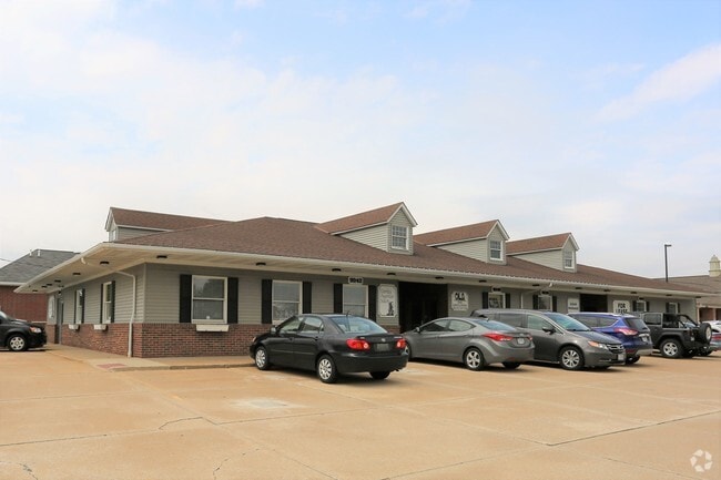
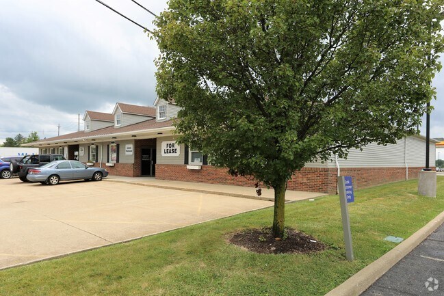
Property Record
9242 Broadview Rd, Broadview Heights, OH 44147

Property Detail
9242 Broadview Rd
583-03-013
OL 23 S/L 23 FF 155.54 DEPTH 130 AC .415
Stripcommercialcenter
Cuyahoga
C-2
Ohio
B and X Area of moderate flood hazard, usually the area between the limits of the 100-year and 500-year floods.
23
2025
0.42 AC
2025
Southwest
136104
Cleveland
7,740 SF
Cleveland-Elyria, OH
NEARBY LISTINGS FOR SALE OR LEASE
DEMOGRAPHICS near 9242 Broadview Rd
1 mile
3 mile
5 mile
2025 Total Population
4,149
38,628
95,385
2030 Population
4,119
38,165
94,618
Pop Growth 2025-2030
(0.72%)
(1.20%)
(0.80%)
Average Age
39
44
44
2025 Total Households
1,701
15,746
39,584
HH Growth 2025-2030
(0.82%)
(1.32%)
(0.86%)
Median Household Inc
$89,099
$102,868
$93,579
Avg Household Size
2.40
2.40
2.30
2025 Avg HH Vehicles
2.00
2.00
2.00
Median Home Value
$363,414
$327,664
$288,469
Median Year Built
1980
1981
1976
Nearby Places
Map Layers
Map Styles
 Street
 Aerial
Layers
 Traffic
 Biking
Places
Listings with unknown addresses are not visible on the map
- Restaurants
- Banks
- Shops
- Fitness
- Groceries
PUBLIC TRANSPORTATION
COMMUTER RAIL
Drive
Walk
Distance
12 min
5.5 mi
Drive
Walk
Distance
15 min
7.6 mi
AIRPORT
Cleveland-Hopkins International
Drive
Walk
Distance
Cleveland-Hopkins International
27 min
15.4 mi
Akron-Canton Regional
Drive
Walk
Distance
Akron-Canton Regional
49 min
37.2 mi
SALE & LEASE HISTORY
LISTING DATE
SALE/LEASE

Jan 18, 2017
For Lease
Nearby Properties
Address
Land Use
TOTAL SIZE
Lot Size
Zoning
Address
Land Use
TOTAL SIZE
Lot Size
Zoning
105,027 SF
14.05 AC
O-L
Address
Land Use
TOTAL SIZE
Lot Size
Zoning
485,330 SF
47.02 AC
TCD
Address
Land Use
TOTAL SIZE
Lot Size
Zoning
154,702 SF
23.37 AC
PF
Address
Land Use
TOTAL SIZE
Lot Size
Zoning
162,134 SF
12.24 AC
CG
Address
Land Use
TOTAL SIZE
Lot Size
Zoning
285,065 SF
5.43 AC
D-1
Address
Land Use
TOTAL SIZE
Lot Size
Zoning
614 SF
19.13 AC
RRZ
Address
Land Use
TOTAL SIZE
Lot Size
Zoning
166,699 SF
65.80 AC
B-5
Address
Land Use
TOTAL SIZE
Lot Size
Zoning
149,522 SF
19.09 AC
PF
Address
Land Use
TOTAL SIZE
Lot Size
Zoning
48,682 SF
4.64 AC
C-4
Address
Land Use
TOTAL SIZE
Lot Size
Zoning
63,282 SF
20.09 AC
O-B
Address
Land Use
TOTAL SIZE
Lot Size
Zoning
28,189 SF
15.33 AC
B-1OR2
Address
Land Use
TOTAL SIZE
Lot Size
Zoning
10,560 SF
22.12 AC
RM-D
Address
Land Use
TOTAL SIZE
Lot Size
Zoning
188,503 SF
23.72 AC
D-1
Address
Land Use
TOTAL SIZE
Lot Size
Zoning
204,594 SF
22.97 AC
R1-A
Address
Land Use
TOTAL SIZE
Lot Size
Zoning
24,900 SF
4.42 AC
B-1OR2
Address
Land Use
TOTAL SIZE
Lot Size
Zoning
55,332 SF
3.01 AC
E-2
Address
Land Use
TOTAL SIZE
Lot Size
Zoning
89,807 SF
7.29 AC
Address
Land Use
TOTAL SIZE
Lot Size
Zoning
49,470 SF
6.61 AC
E-1
Address
Land Use
TOTAL SIZE
Lot Size
Zoning
83,495 SF
9.70 AC
E-1
Address
Land Use
TOTAL SIZE
Lot Size
Zoning
11.97 AC
R-8
Address
Land Use
TOTAL SIZE
Lot Size
Zoning
142,510 SF
13.87 AC
E-2
Address
Land Use
TOTAL SIZE
Lot Size
Zoning
59,813 SF
5.56 AC
Address
Land Use
TOTAL SIZE
Lot Size
Zoning
49,388 SF
29.19 AC
C-F
Address
Land Use
TOTAL SIZE
Lot Size
Zoning
49,811 SF
21.80 AC
A-1
Address
Land Use
TOTAL SIZE
Lot Size
Zoning
111,152 SF
80.99 AC
C-F
Address
Land Use
TOTAL SIZE
Lot Size
Zoning
37,452 SF
16.24 AC
D-1
Address
Land Use
TOTAL SIZE
Lot Size
Zoning
123.70 AC
A-1
Address
Land Use
TOTAL SIZE
Lot Size
Zoning
13,258 SF
2.19 AC
R-8
Address
Land Use
TOTAL SIZE
Lot Size
Zoning
78,800 SF
38.13 AC
NONE
Address
Land Use
TOTAL SIZE
Lot Size
Zoning
128,610 SF
7.71 AC
C-2
The World's #1 Commercial Real Estate Marketplace
Connect with us
© 2026 CoStar Group
The information above has been obtained from sources believed reliable. While we do not doubt its accuracy we have not verified it and make no guarantee, warranty or representation about it. It is your responsibility to independently confirm its accuracy and completeness. Any projections, opinions, assumptions, or estimates used are for example only and do not represent the current or future performance of the property. The value of this transaction to you depends on tax and other factors which should be evaluated by your tax, financial, and legal advisors. You and your advisors should conduct a careful, independent investigation of the property to determine to your satisfaction the suitability of the property for your needs.