Property Record
925 Long Ridge Rd, Stamford, CT 06902
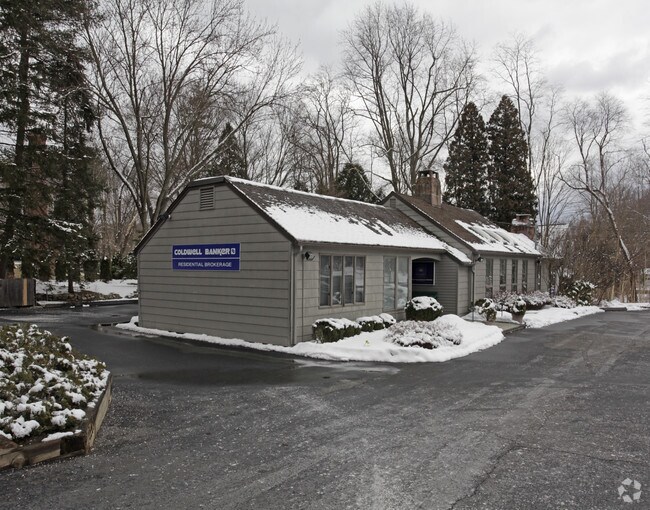

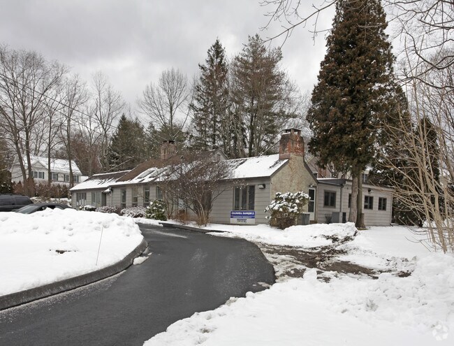
Property Detail
925 Long Ridge Rd
Commercialbuilding
Western Ct
R10
Connecticut
B and X Area of moderate flood hazard, usually the area between the limits of the 100-year and 500-year floods.
1.06 AC
2025
Stamford
2025
Westchester/So Connecticut
020600
Bridgeport-Stamford-Danbury, CT
3,768 SF
STAM-000004-000000-002684
NEARBY LISTINGS FOR SALE OR LEASE
DEMOGRAPHICS near 925 Long Ridge Rd
1 mile
3 mile
5 mile
2024 Total Population
6,613
58,870
189,929
2029 Population
6,744
60,336
194,687
Pop Growth 2024-2029
+ 1.98%
+ 2.49%
+ 2.51%
Average Age
44
42
40
2024 Total Households
2,319
21,840
71,939
HH Growth 2024-2029
+ 1.90%
+ 2.51%
+ 2.70%
Median Household Inc
$156,736
$141,093
$123,524
Avg Household Size
2.70
2.60
2.50
2024 Avg HH Vehicles
2.00
2.00
2.00
Median Home Value
$823,377
$777,512
$859,630
Median Year Built
1961
1965
1970
Nearby Places
Map Layers
Map Styles
 Street
 Aerial
Transit
 Traffic
 Biking
Places
Listings with unknown addresses are not visible on the map
- Restaurants
- Banks
- Shops
- Fitness
- Groceries
PUBLIC TRANSPORTATION
COMMUTER RAIL
Talmadge Hill Station (New Haven Line - Metro-North Commuter Railroad Company (Metro-North))
Drive
Walk
Distance
Talmadge Hill Station (New Haven Line - Metro-North Commuter Railroad Company (Metro-North))
6 min
4.1 mi
Glenbrook Station (New Haven Line - Metro-North Commuter Railroad Company (Metro-North))
Drive
Walk
Distance
Glenbrook Station (New Haven Line - Metro-North Commuter Railroad Company (Metro-North))
10 min
4.3 mi
AIRPORT
Westchester County
Drive
Walk
Distance
Westchester County
23 min
13.6 mi
LaGuardia
Drive
Walk
Distance
LaGuardia
57 min
36.4 mi
Freight Ports
Port of New Haven
Drive
Walk
Distance
Port of New Haven
58 min
41.5 mi
Nearby Properties
Address
Land Use
TOTAL SIZE
Lot Size
Zoning
Address
Land Use
TOTAL SIZE
Lot Size
Zoning
13.21 AC
CSCD
Address
Land Use
TOTAL SIZE
Lot Size
Zoning
9.62 AC
MZN
Address
Land Use
TOTAL SIZE
Lot Size
Zoning
98,106 SF
42.71 AC
RA-2
Address
Land Use
TOTAL SIZE
Lot Size
Zoning
377,918 SF
22.42 AC
MZN
Address
Land Use
TOTAL SIZE
Lot Size
Zoning
32.43 AC
RA1
Address
Land Use
TOTAL SIZE
Lot Size
Zoning
4.53 AC
RH
Address
Land Use
TOTAL SIZE
Lot Size
Zoning
25.91 AC
MZN
Address
Land Use
TOTAL SIZE
Lot Size
Zoning
229,644 SF
3.12 AC
RH
Address
Land Use
TOTAL SIZE
Lot Size
Zoning
29.87 AC
R10
Address
Land Use
TOTAL SIZE
Lot Size
Zoning
272,801 SF
4.32 AC
MZN
Address
Land Use
TOTAL SIZE
Lot Size
Zoning
193,840 SF
18.60 AC
R75
Address
Land Use
TOTAL SIZE
Lot Size
Zoning
26.11 AC
CN
Address
Land Use
TOTAL SIZE
Lot Size
Zoning
75,531 SF
6.85 AC
MZN
Address
Land Use
TOTAL SIZE
Lot Size
Zoning
277,836 SF
2.17 AC
CB
Address
Land Use
TOTAL SIZE
Lot Size
Zoning
34.05 AC
RA1
Address
Land Use
TOTAL SIZE
Lot Size
Zoning
16.99 AC
CD
Address
Land Use
TOTAL SIZE
Lot Size
Zoning
28.54 AC
R20
Address
Land Use
TOTAL SIZE
Lot Size
Zoning
10.84 AC
R75
Address
Land Use
TOTAL SIZE
Lot Size
Zoning
173,641 SF
2.41 AC
RH
Address
Land Use
TOTAL SIZE
Lot Size
Zoning
23.84 AC
CD
Address
Land Use
TOTAL SIZE
Lot Size
Zoning
219,634 SF
10 AC
CD
Address
Land Use
TOTAL SIZE
Lot Size
Zoning
7.84 AC
BD
Address
Land Use
TOTAL SIZE
Lot Size
Zoning
173,641 SF
2.24 AC
RH
Address
Land Use
TOTAL SIZE
Lot Size
Zoning
196,860 SF
CN
Address
Land Use
TOTAL SIZE
Lot Size
Zoning
40.46 AC
RA2
Address
Land Use
TOTAL SIZE
Lot Size
Zoning
3,705 SF
158.41 AC
RA-2
Address
Land Use
TOTAL SIZE
Lot Size
Zoning
160,203 SF
12.38 AC
MZN
Address
Land Use
TOTAL SIZE
Lot Size
Zoning
159,463 SF
6.08 AC
R75
Address
Land Use
TOTAL SIZE
Lot Size
Zoning
16.96 AC
R20
Address
Land Use
TOTAL SIZE
Lot Size
Zoning
90,690 SF
12.80 AC
R20
The World's #1 Commercial Real Estate Marketplace
Connect with us
© 2026 CoStar Group
The information above has been obtained from sources believed reliable. While we do not doubt its accuracy we have not verified it and make no guarantee, warranty or representation about it. It is your responsibility to independently confirm its accuracy and completeness. Any projections, opinions, assumptions, or estimates used are for example only and do not represent the current or future performance of the property. The value of this transaction to you depends on tax and other factors which should be evaluated by your tax, financial, and legal advisors. You and your advisors should conduct a careful, independent investigation of the property to determine to your satisfaction the suitability of the property for your needs.