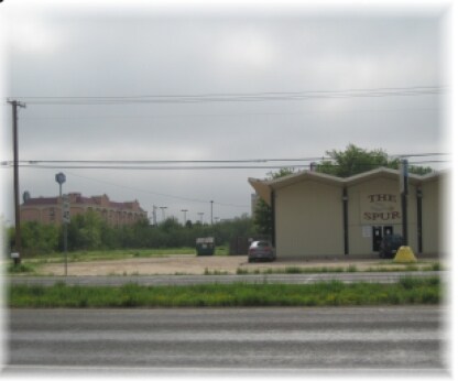
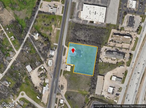
Property Record
926 S Lacy Dr, Waco, TX 76705
NEARBY LISTINGS FOR SALE OR LEASE
Property Detail
926 S Lacy Dr
Waco, TX
Tomas De La Vega
28-057000-017600-7
TOMAS DE LA VEGA TRACT 8 ACRES 3.39
Commercialnec
Mclennan
A
Texas
48309C0380D
8
2024
3.39 AC
2025
Waco & Killeen
001600
Other Market Areas
3,600 SF
DEMOGRAPHICS near 926 S Lacy Dr
1 Mile
3 Mile
5 Mile
2024 Total Population
5,346
28,402
54,712
2029 Population
5,746
30,493
58,597
Pop Growth 2024-2029
+ 7.48%
+ 7.36%
+ 7.10%
Average Age
36
35
36
2024 Total Households
2,163
10,244
20,241
HH Growth 2024-2029
+ 7.67%
+ 7.55%
+ 7.32%
Median Household Inc
$43,440
$44,207
$41,364
Avg Household Size
2.40
2.60
2.50
2024 Avg HH Vehicles
2.00
2.00
2.00
Median Home Value
$149,707
$130,774
$135,417
Median Year Built
1982
1980
1976
Nearby Places
Map Layers
Map Styles
 Street
 Aerial
- Restaurants
- Banks
- Shops
- Fitness
- Groceries
PUBLIC TRANSPORTATION
AIRPORT
Waco Regional
DRIVE
WALK
Distance
Waco Regional
19 min
9.1 mi
Freight Ports
Port of Houston
DRIVE
WALK
Distance
Port of Houston
215 min
187.0 mi
Nearby Properties
Address
Land Use
TOTAL SIZE
Lot Size
Zoning
Address
Land Use
TOTAL SIZE
Lot Size
Zoning
215,433 SF
33.17 AC
R
Address
Land Use
TOTAL SIZE
Lot Size
Zoning
193,780 SF
14.12 AC
C
Address
Land Use
TOTAL SIZE
Lot Size
Zoning
30.89 AC
R1
Address
Land Use
TOTAL SIZE
Lot Size
Zoning
206,113 SF
7.33 AC
2007TIF
Address
Land Use
TOTAL SIZE
Lot Size
Zoning
33,442 SF
2.80 AC
Address
Land Use
TOTAL SIZE
Lot Size
Zoning
127,979 SF
5.72 AC
R
Address
Land Use
TOTAL SIZE
Lot Size
Zoning
186,588 SF
10.28 AC
C1
Address
Land Use
TOTAL SIZE
Lot Size
Zoning
21.76 AC
R
Address
Land Use
TOTAL SIZE
Lot Size
Zoning
293,368 SF
21.23 AC
M3
Address
Land Use
TOTAL SIZE
Lot Size
Zoning
13.72 AC
R1
Address
Land Use
TOTAL SIZE
Lot Size
Zoning
8.86 AC
R1
Address
Land Use
TOTAL SIZE
Lot Size
Zoning
1,174,171 SF
44.99 AC
M3
Address
Land Use
TOTAL SIZE
Lot Size
Zoning
87,206 SF
2.80 AC
Address
Land Use
TOTAL SIZE
Lot Size
Zoning
34.95 AC
R1B
Address
Land Use
TOTAL SIZE
Lot Size
Zoning
202,787 SF
22.33 AC
B2
Address
Land Use
TOTAL SIZE
Lot Size
Zoning
50,570 SF
6.25 AC
2007 TIF
Address
Land Use
TOTAL SIZE
Lot Size
Zoning
102,910 SF
6.38 AC
TIF2
Address
Land Use
TOTAL SIZE
Lot Size
Zoning
239,020 SF
38.81 AC
R1B
Address
Land Use
TOTAL SIZE
Lot Size
Zoning
132,772 SF
27.36 AC
C
Address
Land Use
TOTAL SIZE
Lot Size
Zoning
125,412 SF
8.37 AC
R
Address
Land Use
TOTAL SIZE
Lot Size
Zoning
102,480 SF
9.36 AC
R4
Address
Land Use
TOTAL SIZE
Lot Size
Zoning
75,523 SF
17.78 AC
R1
Address
Land Use
TOTAL SIZE
Lot Size
Zoning
68,942 SF
2.13 AC
C1
Address
Land Use
TOTAL SIZE
Lot Size
Zoning
69,642 SF
27.76 AC
R1B
Address
Land Use
TOTAL SIZE
Lot Size
Zoning
99,124 SF
5 AC
B2
Address
Land Use
TOTAL SIZE
Lot Size
Zoning
47.44 AC
Address
Land Use
TOTAL SIZE
Lot Size
Zoning
55,756 SF
7.72 AC
R
Address
Land Use
TOTAL SIZE
Lot Size
Zoning
67,229 SF
3.22 AC
R
Address
Land Use
TOTAL SIZE
Lot Size
Zoning
94,428 SF
6.20 AC
B1
Address
Land Use
TOTAL SIZE
Lot Size
Zoning
50,814 SF
12.44 AC
B2
The World's #1 Commercial Real Estate Marketplace
Connect with us
© 2026 CoStar Group
The information above has been obtained from sources believed reliable. While we do not doubt its accuracy we have not verified it and make no guarantee, warranty or representation about it. It is your responsibility to independently confirm its accuracy and completeness. Any projections, opinions, assumptions, or estimates used are for example only and do not represent the current or future performance of the property. The value of this transaction to you depends on tax and other factors which should be evaluated by your tax, financial, and legal advisors. You and your advisors should conduct a careful, independent investigation of the property to determine to your satisfaction the suitability of the property for your needs.