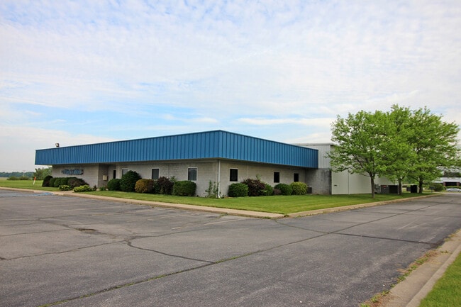
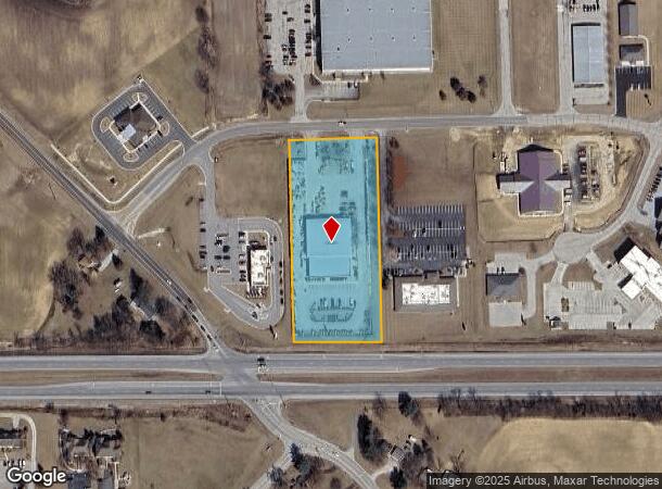
Property Record
927 W Connexion Way, Columbia City, IN 46725


NEARBY LISTINGS FOR SALE OR LEASE
Property Detail
927 W Connexion Way
92-06-03-717-009.000-004
LOT 9 3.00A ARMSTRONG CORPORATE PARK SEC 3
Commercialnec
Whitley
X
Indiana
18183C0145C
9
2024
3 AC
2024
Outlying Whitley County
050402
Fort Wayne
17,000 SF
Fort Wayne, IN
DEMOGRAPHICS near 927 W Connexion Way
1 Mile
3 Mile
5 Mile
2024 Total Population
1,784
11,873
15,767
2029 Population
1,884
12,525
16,599
Pop Growth 2024-2029
+ 5.61%
+ 5.49%
+ 5.28%
Average Age
43
39
40
2024 Total Households
729
4,911
6,440
HH Growth 2024-2029
+ 5.62%
+ 5.48%
+ 5.23%
Median Household Inc
$79,969
$60,914
$63,532
Avg Household Size
2.30
2.30
2.40
2024 Avg HH Vehicles
2.00
2.00
2.00
Median Home Value
$201,659
$164,541
$174,446
Median Year Built
1981
1982
1982
Nearby Places
Map Layers
Map Styles
 Street
 Aerial
- Restaurants
- Banks
- Shops
- Fitness
- Groceries
PUBLIC TRANSPORTATION
AIRPORT
Fort Wayne International
DRIVE
WALK
Distance
Fort Wayne International
46 min
28.7 mi
Freight Ports
Port of Toledo
DRIVE
WALK
Distance
Port of Toledo
166 min
127.7 mi
SALE & LEASE HISTORY
LISTING DATE
SALE/LEASE

Jun 01, 2021
For Sale
Nearby Properties
Address
Land Use
TOTAL SIZE
Lot Size
Zoning
Address
Land Use
TOTAL SIZE
Lot Size
Zoning
108,834 SF
39.70 AC
Address
Land Use
TOTAL SIZE
Lot Size
Zoning
43,097 SF
20 AC
Address
Land Use
TOTAL SIZE
Lot Size
Zoning
60,204 SF
0.63 AC
Address
Land Use
TOTAL SIZE
Lot Size
Zoning
41,936 SF
1 AC
Address
Land Use
TOTAL SIZE
Lot Size
Zoning
47,154 SF
16.19 AC
Address
Land Use
TOTAL SIZE
Lot Size
Zoning
115,418 SF
9.18 AC
Address
Land Use
TOTAL SIZE
Lot Size
Zoning
69,446 SF
7.84 AC
Address
Land Use
TOTAL SIZE
Lot Size
Zoning
50,796 SF
5.56 AC
Address
Land Use
TOTAL SIZE
Lot Size
Zoning
17,520 SF
3.54 AC
Address
Land Use
TOTAL SIZE
Lot Size
Zoning
40,419 SF
1.21 AC
Address
Land Use
TOTAL SIZE
Lot Size
Zoning
37,439 SF
38.80 AC
Address
Land Use
TOTAL SIZE
Lot Size
Zoning
23,796 SF
1 AC
Address
Land Use
TOTAL SIZE
Lot Size
Zoning
146 SF
38.17 AC
Address
Land Use
TOTAL SIZE
Lot Size
Zoning
49,840 SF
7.51 AC
Address
Land Use
TOTAL SIZE
Lot Size
Zoning
38,016 SF
3.07 AC
Address
Land Use
TOTAL SIZE
Lot Size
Zoning
38,016 SF
3.29 AC
Address
Land Use
TOTAL SIZE
Lot Size
Zoning
13,692 SF
3.07 AC
Address
Land Use
TOTAL SIZE
Lot Size
Zoning
20,036 SF
8.79 AC
Address
Land Use
TOTAL SIZE
Lot Size
Zoning
63,600 SF
10 AC
Address
Land Use
TOTAL SIZE
Lot Size
Zoning
8,980 SF
1.02 AC
Address
Land Use
TOTAL SIZE
Lot Size
Zoning
28,338 SF
2 AC
Address
Land Use
TOTAL SIZE
Lot Size
Zoning
4,326 SF
0.99 AC
Address
Land Use
TOTAL SIZE
Lot Size
Zoning
20,300 SF
1.37 AC
Address
Land Use
TOTAL SIZE
Lot Size
Zoning
12,176 SF
2.09 AC
Address
Land Use
TOTAL SIZE
Lot Size
Zoning
3,024 SF
1 AC
Address
Land Use
TOTAL SIZE
Lot Size
Zoning
3,605 SF
1.11 AC
Address
Land Use
TOTAL SIZE
Lot Size
Zoning
33,212 SF
3.12 AC
Address
Land Use
TOTAL SIZE
Lot Size
Zoning
15,894 SF
0.29 AC
Address
Land Use
TOTAL SIZE
Lot Size
Zoning
14,820 SF
1.47 AC
Address
Land Use
TOTAL SIZE
Lot Size
Zoning
78,108 SF
1.01 AC
The World's #1 Commercial Real Estate Marketplace
Connect with us
© 2025 CoStar Group
The information above has been obtained from sources believed reliable. While we do not doubt its accuracy we have not verified it and make no guarantee, warranty or representation about it. It is your responsibility to independently confirm its accuracy and completeness. Any projections, opinions, assumptions, or estimates used are for example only and do not represent the current or future performance of the property. The value of this transaction to you depends on tax and other factors which should be evaluated by your tax, financial, and legal advisors. You and your advisors should conduct a careful, independent investigation of the property to determine to your satisfaction the suitability of the property for your needs.