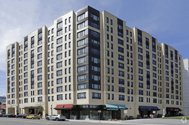
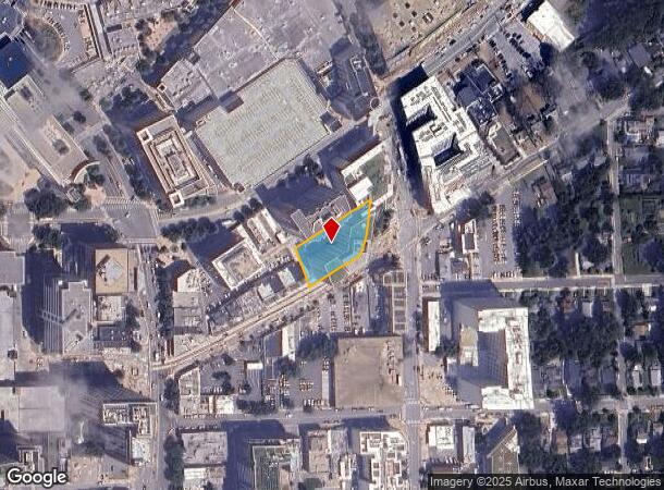
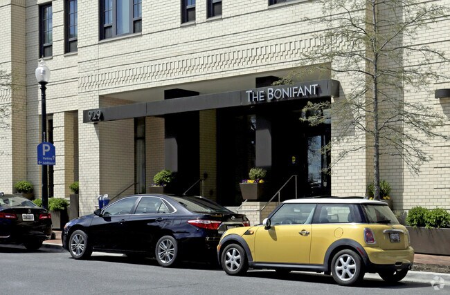
Property Record
929 Bonifant St, Silver Spring, MD 20910
NEARBY LISTINGS FOR SALE OR LEASE
Property Detail
929 Bonifant St
Washington-Arlington-Alexandria, DC-VA-MD-WV
Silver Spring
13-03735192
Montgomery
Condominium
Maryland
X
0.48 AC
24033C0110E
Downtown Silver Spring
125,500 SF
Washington, DC
DEMOGRAPHICS near 929 Bonifant St
1 Mile
3 Mile
5 Mile
2024 Total Population
41,280
236,200
599,498
2029 Population
40,732
228,238
574,851
Pop Growth 2024-2029
(1.33%)
(3.37%)
(4.11%)
Average Age
38
38
38
2024 Total Households
20,452
87,339
231,231
HH Growth 2024-2029
(1.24%)
(3.60%)
(4.65%)
Median Household Inc
$98,738
$96,313
$99,618
Avg Household Size
2.00
2.60
2.40
2024 Avg HH Vehicles
1.00
1.00
1.00
Median Home Value
$678,875
$642,764
$665,709
Median Year Built
1968
1957
1958
Nearby Places
Map Layers
Map Styles
 Street
 Aerial
- Restaurants
- Banks
- Shops
- Fitness
- Groceries
PUBLIC TRANSPORTATION
TRANSIT/SUBWAY
Silver Spring (Red Line - Washington Metropolitan Area Transit Authority Metrorail (Metrorail))
DRIVE
WALK
Distance
Silver Spring (Red Line - Washington Metropolitan Area Transit Authority Metrorail (Metrorail))
4 min
7 min
0.4 mi
COMMUTER RAIL
Silver Spring (Brunswick Line - Maryland Area Regional Commuter Trains (The MARC))
DRIVE
WALK
Distance
Silver Spring (Brunswick Line - Maryland Area Regional Commuter Trains (The MARC))
1 min
5 min
0.3 mi
Kensington (Brunswick Line - Maryland Area Regional Commuter Trains (The MARC))
DRIVE
WALK
Distance
Kensington (Brunswick Line - Maryland Area Regional Commuter Trains (The MARC))
11 min
3.7 mi
AIRPORT
Ronald Reagan Washington Ntl
DRIVE
WALK
Distance
Ronald Reagan Washington Ntl
31 min
13.0 mi
Baltimore/Washington International Thurgood Marshall
DRIVE
WALK
Distance
Baltimore/Washington International Thurgood Marshall
35 min
29.5 mi
Washington Dulles International
DRIVE
WALK
Distance
Washington Dulles International
37 min
29.5 mi
Freight Ports
Port of Baltimore
DRIVE
WALK
Distance
Port of Baltimore
1 min
29.5 mi
SALE & LEASE HISTORY
LISTING DATE
SALE/LEASE

Sep 25, 2016
For Lease
Oct 13, 2017
For Lease
Oct 09, 2017
For Lease
Oct 09, 2017
For Lease
Nov 07, 2022
For Lease
Nearby Properties
Address
Land Use
TOTAL SIZE
Lot Size
Zoning
Address
Land Use
TOTAL SIZE
Lot Size
Zoning
70,860 SF
1,616.16 AC
R-1A;UNZON
Address
Land Use
TOTAL SIZE
Lot Size
Zoning
775,490 SF
14.21 AC
R60
Address
Land Use
TOTAL SIZE
Lot Size
Zoning
1,144,541 SF
30.46 AC
CR2.5
Address
Land Use
TOTAL SIZE
Lot Size
Zoning
919,016 SF
3.25 AC
CR5.0
Address
Land Use
TOTAL SIZE
Lot Size
Zoning
505,000 SF
1.97 AC
CR8.0
Address
Land Use
TOTAL SIZE
Lot Size
Zoning
487,112 SF
3.19 AC
CR3.0
Address
Land Use
TOTAL SIZE
Lot Size
Zoning
302,861 SF
16.30 AC
R-1A
Address
Land Use
TOTAL SIZE
Lot Size
Zoning
400,000 SF
0.93 AC
CR5.0
Address
Land Use
TOTAL SIZE
Lot Size
Zoning
383,000 SF
2.29 AC
WR-3;WR-4
Address
Land Use
TOTAL SIZE
Lot Size
Zoning
14.89 AC
R-1A
Address
Land Use
TOTAL SIZE
Lot Size
Zoning
305,000 SF
1.62 AC
CR5.0
Address
Land Use
TOTAL SIZE
Lot Size
Zoning
247,494 SF
WR-3;WR-5;
Address
Land Use
TOTAL SIZE
Lot Size
Zoning
134,394 SF
6.05 AC
WR-7;WR-8
Address
Land Use
TOTAL SIZE
Lot Size
Zoning
756,363 SF
2.66 AC
CR8.0
Address
Land Use
TOTAL SIZE
Lot Size
Zoning
403,200 SF
1.41 AC
CR5.0
Address
Land Use
TOTAL SIZE
Lot Size
Zoning
406,784 SF
1.75 AC
CR3.0
Address
Land Use
TOTAL SIZE
Lot Size
Zoning
590 SF
20.11 AC
LTOE
Address
Land Use
TOTAL SIZE
Lot Size
Zoning
386,567 SF
29.70 AC
R60
Address
Land Use
TOTAL SIZE
Lot Size
Zoning
301,045 SF
13.51 AC
R-1B
Address
Land Use
TOTAL SIZE
Lot Size
Zoning
304,888 SF
1.72 AC
CR5.0
Address
Land Use
TOTAL SIZE
Lot Size
Zoning
310,000 SF
1.01 AC
CR8.0
Address
Land Use
TOTAL SIZE
Lot Size
Zoning
269,319 SF
2.26 AC
MU-4;RA-1
Address
Land Use
TOTAL SIZE
Lot Size
Zoning
347,098 SF
7.27 AC
R60
Address
Land Use
TOTAL SIZE
Lot Size
Zoning
480,733 SF
2.10 AC
CR8.0
Address
Land Use
TOTAL SIZE
Lot Size
Zoning
524,982 SF
7.90 AC
R10
Address
Land Use
TOTAL SIZE
Lot Size
Zoning
111,525 SF
5.29 AC
R-1B
Address
Land Use
TOTAL SIZE
Lot Size
Zoning
468 SF
9.75 AC
RMF48
Address
Land Use
TOTAL SIZE
Lot Size
Zoning
5.03 AC
WR-4
Address
Land Use
TOTAL SIZE
Lot Size
Zoning
664,858 SF
106.79 AC
R90
Address
Land Use
TOTAL SIZE
Lot Size
Zoning
293,722 SF
35.95 AC
LSC0.
The World's #1 Commercial Real Estate Marketplace
Connect with us
© 2025 CoStar Group
The information above has been obtained from sources believed reliable. While we do not doubt its accuracy we have not verified it and make no guarantee, warranty or representation about it. It is your responsibility to independently confirm its accuracy and completeness. Any projections, opinions, assumptions, or estimates used are for example only and do not represent the current or future performance of the property. The value of this transaction to you depends on tax and other factors which should be evaluated by your tax, financial, and legal advisors. You and your advisors should conduct a careful, independent investigation of the property to determine to your satisfaction the suitability of the property for your needs.