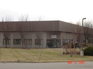
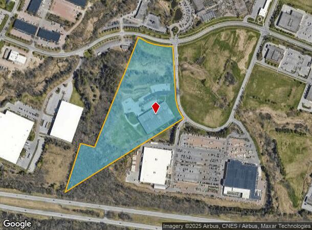
Property Record
929 Harvest Ln, Williston, VT 05495
NEARBY LISTINGS FOR SALE OR LEASE
Property Detail
929 Harvest Ln
(241) 07106034000
18.06A W/COMMERCIAL WAREHOUSE - LOT 22
Commercialnec
Chittenden
X
Vermont
50007C0278D
18.06 AC
0
Vermont North Area
2024
Other Market Areas
003101
Burlington-South Burlington, VT
69,960 SF
DEMOGRAPHICS near 929 Harvest Ln
1 Mile
3 Mile
5 Mile
2024 Total Population
1,739
18,630
80,546
2029 Population
1,790
18,879
81,690
Pop Growth 2024-2029
+ 2.93%
+ 1.34%
+ 1.42%
Average Age
42
42
38
2024 Total Households
871
8,067
32,578
HH Growth 2024-2029
+ 3.33%
+ 1.46%
+ 1.53%
Median Household Inc
$84,264
$97,013
$83,823
Avg Household Size
1.90
2.20
2.20
2024 Avg HH Vehicles
2.00
2.00
2.00
Median Home Value
$392,499
$384,017
$383,890
Median Year Built
2002
1987
1981
Nearby Places
Map Layers
Map Styles
 Street
 Aerial
- Restaurants
- Banks
- Shops
- Fitness
- Groceries
PUBLIC TRANSPORTATION
COMMUTER RAIL
Essex Junction-Burlington Amtrak Station (Vermonter - Amtrak)
DRIVE
WALK
Distance
Essex Junction-Burlington Amtrak Station (Vermonter - Amtrak)
8 min
4.1 mi
Btn (Ethan Allen Express - Amtrak)
DRIVE
WALK
Distance
Btn (Ethan Allen Express - Amtrak)
14 min
7.9 mi
AIRPORT
Patrick Leahy Burlington International
DRIVE
WALK
Distance
Patrick Leahy Burlington International
17 min
5.3 mi
Plattsburgh International
DRIVE
WALK
Distance
Plattsburgh International
72 min
39.3 mi
Freight Ports
Montreal
DRIVE
WALK
Distance
Montreal
131 min
102.6 mi
Nearby Properties
Address
Land Use
TOTAL SIZE
Lot Size
Zoning
Address
Land Use
TOTAL SIZE
Lot Size
Zoning
227.57 AC
Address
Land Use
TOTAL SIZE
Lot Size
Zoning
Address
Land Use
TOTAL SIZE
Lot Size
Zoning
Address
Land Use
TOTAL SIZE
Lot Size
Zoning
Address
Land Use
TOTAL SIZE
Lot Size
Zoning
Address
Land Use
TOTAL SIZE
Lot Size
Zoning
736.20 AC
Address
Land Use
TOTAL SIZE
Lot Size
Zoning
Address
Land Use
TOTAL SIZE
Lot Size
Zoning
52,824 SF
14.43 AC
Address
Land Use
TOTAL SIZE
Lot Size
Zoning
54,000 SF
3.98 AC
Address
Land Use
TOTAL SIZE
Lot Size
Zoning
Address
Land Use
TOTAL SIZE
Lot Size
Zoning
54,000 SF
5 AC
Address
Land Use
TOTAL SIZE
Lot Size
Zoning
64,000 SF
68 AC
Address
Land Use
TOTAL SIZE
Lot Size
Zoning
69,120 SF
11.20 AC
Address
Land Use
TOTAL SIZE
Lot Size
Zoning
35,064 SF
3.71 AC
Address
Land Use
TOTAL SIZE
Lot Size
Zoning
78.78 AC
Address
Land Use
TOTAL SIZE
Lot Size
Zoning
Address
Land Use
TOTAL SIZE
Lot Size
Zoning
Address
Land Use
TOTAL SIZE
Lot Size
Zoning
Address
Land Use
TOTAL SIZE
Lot Size
Zoning
Address
Land Use
TOTAL SIZE
Lot Size
Zoning
3,825 SF
44 AC
Address
Land Use
TOTAL SIZE
Lot Size
Zoning
30,000 SF
4.52 AC
Address
Land Use
TOTAL SIZE
Lot Size
Zoning
30,600 SF
2.94 AC
Address
Land Use
TOTAL SIZE
Lot Size
Zoning
Address
Land Use
TOTAL SIZE
Lot Size
Zoning
54,446 SF
6.43 AC
Address
Land Use
TOTAL SIZE
Lot Size
Zoning
29,150 SF
3.90 AC
Address
Land Use
TOTAL SIZE
Lot Size
Zoning
Address
Land Use
TOTAL SIZE
Lot Size
Zoning
86,304 SF
1.07 AC
Address
Land Use
TOTAL SIZE
Lot Size
Zoning
Address
Land Use
TOTAL SIZE
Lot Size
Zoning
273.50 AC
Address
Land Use
TOTAL SIZE
Lot Size
Zoning
The World's #1 Commercial Real Estate Marketplace
Connect with us
© 2025 CoStar Group
The information above has been obtained from sources believed reliable. While we do not doubt its accuracy we have not verified it and make no guarantee, warranty or representation about it. It is your responsibility to independently confirm its accuracy and completeness. Any projections, opinions, assumptions, or estimates used are for example only and do not represent the current or future performance of the property. The value of this transaction to you depends on tax and other factors which should be evaluated by your tax, financial, and legal advisors. You and your advisors should conduct a careful, independent investigation of the property to determine to your satisfaction the suitability of the property for your needs.