Property Record
929 Riverside Dr, North Grosvenordale, CT 06255

NEARBY LISTINGS FOR SALE OR LEASE
-
-
View all North Grosvenordale listings for lease on LoopNet.com
Property Detail
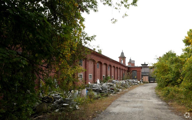
929 Riverside Dr
THOM-000167-000060-000007
Windham
Industrialgeneral
Connecticut
AE
7
09015C0132F
9.44 AC
2024
Windham County
2025
Hartford
900200
Worcester, MA-CT
52,128 SF
DEMOGRAPHICS near 929 Riverside Dr
1 Mile
3 Mile
5 Mile
2024 Total Population
1,566
6,024
37,758
2029 Population
1,554
6,001
37,573
Pop Growth 2024-2029
(0.77%)
(0.38%)
(0.49%)
Average Age
41
43
42
2024 Total Households
657
2,484
15,702
HH Growth 2024-2029
(0.61%)
(0.36%)
(0.45%)
Median Household Inc
$94,106
$85,641
$73,869
Avg Household Size
2.40
2.40
2.30
2024 Avg HH Vehicles
2.00
2.00
2.00
Median Home Value
$241,916
$265,793
$272,402
Median Year Built
1958
1969
1964
Nearby Places
Map Layers
Map Styles
 Street
 Aerial
- Restaurants
- Banks
- Shops
- Fitness
- Groceries
PUBLIC TRANSPORTATION
AIRPORT
Worcester Regional
DRIVE
WALK
Distance
Worcester Regional
42 min
26.9 mi
Freight Ports
Port of Davisville, RI
DRIVE
WALK
Distance
Port of Davisville, RI
72 min
55.1 mi
SALE & LEASE HISTORY
LISTING DATE
SALE/LEASE

Sep 25, 2016
For Lease
Sep 24, 2016
For Sale
Feb 07, 2025
For Lease
Feb 06, 2024
For Lease
Nearby Properties
Address
Land Use
TOTAL SIZE
Lot Size
Zoning
Address
Land Use
TOTAL SIZE
Lot Size
Zoning
35.85 AC
DMRD
Address
Land Use
TOTAL SIZE
Lot Size
Zoning
61,373 SF
121.12 AC
TCVD
Address
Land Use
TOTAL SIZE
Lot Size
Zoning
123,434 SF
49.50 AC
BDD
Address
Land Use
TOTAL SIZE
Lot Size
Zoning
5 AC
TCVD
Address
Land Use
TOTAL SIZE
Lot Size
Zoning
98.97 AC
TCVD
Address
Land Use
TOTAL SIZE
Lot Size
Zoning
2.61 AC
TCDD
Address
Land Use
TOTAL SIZE
Lot Size
Zoning
20,177 SF
3.12 AC
DMRD
Address
Land Use
TOTAL SIZE
Lot Size
Zoning
294 SF
84.14 AC
RRAD
Address
Land Use
TOTAL SIZE
Lot Size
Zoning
17,605 SF
TCVD
Address
Land Use
TOTAL SIZE
Lot Size
Zoning
5,918 SF
13.84 AC
TCDD
Address
Land Use
TOTAL SIZE
Lot Size
Zoning
19.60 AC
DMRD
Address
Land Use
TOTAL SIZE
Lot Size
Zoning
50,324 SF
0.48 AC
BDD
Address
Land Use
TOTAL SIZE
Lot Size
Zoning
5.42 AC
DMRD
Address
Land Use
TOTAL SIZE
Lot Size
Zoning
25,184 SF
TCVD
Address
Land Use
TOTAL SIZE
Lot Size
Zoning
11,013 SF
37.58 AC
TCVD
Address
Land Use
TOTAL SIZE
Lot Size
Zoning
72.25 AC
RRAD
Address
Land Use
TOTAL SIZE
Lot Size
Zoning
5.70 AC
DMRD
Address
Land Use
TOTAL SIZE
Lot Size
Zoning
7 AC
TCVD
Address
Land Use
TOTAL SIZE
Lot Size
Zoning
6,786 SF
RRAD
Address
Land Use
TOTAL SIZE
Lot Size
Zoning
Address
Land Use
TOTAL SIZE
Lot Size
Zoning
23,152 SF
0.91 AC
DMRD
Address
Land Use
TOTAL SIZE
Lot Size
Zoning
9,433 SF
2 AC
DMRD
Address
Land Use
TOTAL SIZE
Lot Size
Zoning
5,070 SF
2.87 AC
DMRD
Address
Land Use
TOTAL SIZE
Lot Size
Zoning
29,918 SF
2.30 AC
BDD
Address
Land Use
TOTAL SIZE
Lot Size
Zoning
3,750 SF
44.32 AC
TCDD
Address
Land Use
TOTAL SIZE
Lot Size
Zoning
2 AC
TCVD
Address
Land Use
TOTAL SIZE
Lot Size
Zoning
1,800 SF
0.35 AC
DMRD
Address
Land Use
TOTAL SIZE
Lot Size
Zoning
5,860 SF
0.61 AC
DMRD
Address
Land Use
TOTAL SIZE
Lot Size
Zoning
13,967 SF
DMRD
The World's #1 Commercial Real Estate Marketplace
Connect with us
© 2025 CoStar Group
The information above has been obtained from sources believed reliable. While we do not doubt its accuracy we have not verified it and make no guarantee, warranty or representation about it. It is your responsibility to independently confirm its accuracy and completeness. Any projections, opinions, assumptions, or estimates used are for example only and do not represent the current or future performance of the property. The value of this transaction to you depends on tax and other factors which should be evaluated by your tax, financial, and legal advisors. You and your advisors should conduct a careful, independent investigation of the property to determine to your satisfaction the suitability of the property for your needs.