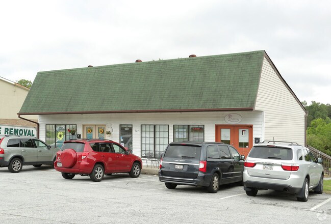
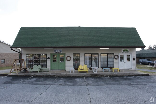
Property Record
929 Senoia Rd, Tyrone, GA 30290
NEARBY LISTINGS FOR SALE OR LEASE
Property Detail
929 Senoia Rd
07-38-07-003
Alton D Brown
Storebuilding
CALYPSO BUSINESS COMPUTER SYS
X
Fayette
13077C0180D
Georgia
2024
0.34 AC
2024
Fayette/Peachtree
140203
Atlanta
1,500 SF
Atlanta-Sandy Springs-Roswell, GA
DEMOGRAPHICS near 929 Senoia Rd
1 Mile
3 Mile
5 Mile
2024 Total Population
1,926
16,122
55,230
2029 Population
2,043
17,220
58,975
Pop Growth 2024-2029
+ 6.07%
+ 6.81%
+ 6.78%
Average Age
42
42
40
2024 Total Households
669
5,682
19,923
HH Growth 2024-2029
+ 6.13%
+ 6.79%
+ 6.66%
Median Household Inc
$82,539
$97,320
$93,027
Avg Household Size
2.90
2.80
2.70
2024 Avg HH Vehicles
2.00
2.00
2.00
Median Home Value
$348,850
$373,531
$364,407
Median Year Built
1995
1996
1997
Nearby Places
Map Layers
Map Styles
 Street
 Aerial
- Restaurants
- Banks
- Shops
- Fitness
- Groceries
PUBLIC TRANSPORTATION
AIRPORT
Hartsfield - Jackson Atlanta International
DRIVE
WALK
Distance
Hartsfield - Jackson Atlanta International
29 min
19.7 mi
Freight Ports
Georgia Ports - Savannah
DRIVE
WALK
Distance
Georgia Ports - Savannah
290 min
246.4 mi
SALE & LEASE HISTORY
LISTING DATE
SALE/LEASE

May 05, 2017
For Sale
Aug 04, 2017
For Lease
Nearby Properties
Address
Land Use
TOTAL SIZE
Lot Size
Zoning
Address
Land Use
TOTAL SIZE
Lot Size
Zoning
412,253 SF
134.50 AC
Address
Land Use
TOTAL SIZE
Lot Size
Zoning
194,839 SF
25.40 AC
C GC
Address
Land Use
TOTAL SIZE
Lot Size
Zoning
39,195 SF
14.06 AC
C GC
Address
Land Use
TOTAL SIZE
Lot Size
Zoning
96,409 SF
12.74 AC
C GC
Address
Land Use
TOTAL SIZE
Lot Size
Zoning
93,925 SF
5.18 AC
C GC
Address
Land Use
TOTAL SIZE
Lot Size
Zoning
80,800 SF
9.39 AC
C C2
Address
Land Use
TOTAL SIZE
Lot Size
Zoning
80,956 SF
60.90 AC
Address
Land Use
TOTAL SIZE
Lot Size
Zoning
125,421 SF
12.99 AC
C GC
Address
Land Use
TOTAL SIZE
Lot Size
Zoning
72,376 SF
30.30 AC
Address
Land Use
TOTAL SIZE
Lot Size
Zoning
14,636 SF
6.50 AC
C OI
Address
Land Use
TOTAL SIZE
Lot Size
Zoning
35,455 SF
2.30 AC
C GC
Address
Land Use
TOTAL SIZE
Lot Size
Zoning
36,900 SF
8.12 AC
C OI
Address
Land Use
TOTAL SIZE
Lot Size
Zoning
49,935 SF
3.99 AC
C GC
Address
Land Use
TOTAL SIZE
Lot Size
Zoning
66,390 SF
3.61 AC
I M1
Address
Land Use
TOTAL SIZE
Lot Size
Zoning
60.89 AC
I M1
Address
Land Use
TOTAL SIZE
Lot Size
Zoning
30,397 SF
24.50 AC
Address
Land Use
TOTAL SIZE
Lot Size
Zoning
12,859 SF
50.50 AC
Address
Land Use
TOTAL SIZE
Lot Size
Zoning
15,440 SF
10.86 AC
C C1
Address
Land Use
TOTAL SIZE
Lot Size
Zoning
17,248 SF
3.47 AC
C OI
Address
Land Use
TOTAL SIZE
Lot Size
Zoning
49,680 SF
2.92 AC
I M2
Address
Land Use
TOTAL SIZE
Lot Size
Zoning
26,022 SF
3.48 AC
C C2
Address
Land Use
TOTAL SIZE
Lot Size
Zoning
72,227 SF
7.40 AC
Address
Land Use
TOTAL SIZE
Lot Size
Zoning
24,100 SF
4.30 AC
C C3
Address
Land Use
TOTAL SIZE
Lot Size
Zoning
27,270 SF
3.28 AC
C C2
Address
Land Use
TOTAL SIZE
Lot Size
Zoning
6,302 SF
3.15 AC
I M2
Address
Land Use
TOTAL SIZE
Lot Size
Zoning
60,099 SF
3.60 AC
Address
Land Use
TOTAL SIZE
Lot Size
Zoning
14,375 SF
1.85 AC
C C1
Address
Land Use
TOTAL SIZE
Lot Size
Zoning
15,184 SF
1.33 AC
C GC
Address
Land Use
TOTAL SIZE
Lot Size
Zoning
17,330 SF
4.16 AC
C OI
Address
Land Use
TOTAL SIZE
Lot Size
Zoning
3,794 SF
1.74 AC
C C2
The World's #1 Commercial Real Estate Marketplace
Connect with us
© 2025 CoStar Group
The information above has been obtained from sources believed reliable. While we do not doubt its accuracy we have not verified it and make no guarantee, warranty or representation about it. It is your responsibility to independently confirm its accuracy and completeness. Any projections, opinions, assumptions, or estimates used are for example only and do not represent the current or future performance of the property. The value of this transaction to you depends on tax and other factors which should be evaluated by your tax, financial, and legal advisors. You and your advisors should conduct a careful, independent investigation of the property to determine to your satisfaction the suitability of the property for your needs.